
Monestier, Allier facts for kids
Quick facts for kids
Monestier
|
|
|---|---|
 |
|

Monestier
Location in France

Monestier
Location in Auvergne-Rhône-Alpes
|
|
| Country | France |
| Region | Auvergne-Rhône-Alpes |
| Department | Allier |
| Arrondissement | Moulins |
| Canton | Chantelle |
| Intercommunality | Sioule, Colettes et Bouble |
| Area
1
|
29.68 km2 (11.46 sq mi) |
| Population
(2008)
|
268 |
| • Density | 9.030/km2 (23.39/sq mi) |
| Time zone | UTC+01:00 (CET) |
| • Summer (DST) | UTC+02:00 (CEST) |
| INSEE/Postal code |
03175 /03140
|
| Elevation | 290–413 m (951–1,355 ft) (avg. 323 m or 1,060 ft) |
| 1 French Land Register data, which excludes lakes, ponds, glaciers > 1 km2 (0.386 sq mi or 247 acres) and river estuaries. | |
Monestier is a small town or village in France. It is officially called a commune. Monestier is located in the Allier department. This department is found in the central part of France.
Contents
About Monestier
Monestier is a quiet place with a small number of people living there. In 2008, about 268 people called Monestier home. The area of the commune is nearly 30 square kilometers. This makes it a medium-sized commune in terms of land.
Where is Monestier Located?
Monestier is part of the Allier department. This department is in the Auvergne-Rhône-Alpes region of France. It is known for its green landscapes and peaceful countryside. Monestier sits in the heart of France.
How High is Monestier?
The land in Monestier is not flat. It has different heights above sea level. The lowest point in the commune is 290 meters high. The highest point reaches 413 meters. The main part of the village is around 323 meters high.
Who Manages Monestier?
Like all communes in France, Monestier has a mayor. The mayor helps run the local government. From 2008 to 2014, Alain Guillaumin was the mayor of Monestier. The commune also works with nearby towns. This cooperation helps them share services and resources.
Images for kids
-
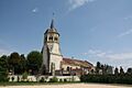
The church in Monestier, Allier.
See also
 In Spanish: Monestier (Allier) para niños
