Monsefú facts for kids
Quick facts for kids
Monsefú
San Pedro de Monsefú
|
||
|---|---|---|

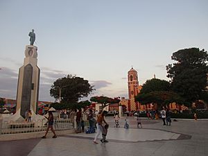
Plaza de Armas of Monsefú
|
||
|
||
| Nickname(s):
The Eternal City of Flowers
|
||
| Motto(s):
Entrepreneurial and Laborious
|
||
| Country | ||
| Region | Lambayeque | |
| Province | Chiclayo | |
| District | Monsefú | |
| Elevated to city | October 26, 1888 | |
| Area | ||
| • Total | 44.94 km2 (17.35 sq mi) | |
| Elevation | 11 m (36 ft) | |
| Population | ||
| • Estimate
(2015)
|
23,561 | |
| Time zone | UTC-5 (PET) | |
| Website | www.munimonsefu.gob.pe | |
Monsefú is a lively town in northern Peru. It is the main town of the Monsefú district, which is part of the Chiclayo Province in the Lambayeque Region. People know Monsefú for its amazing food and beautiful handmade crafts.
Every July, Monsefú hosts a special event called the FEXTICUM festival. This festival started in 1973 and shows off the town's culture. It happens during Fiestas Patrias, which are Peru's national holidays. Monsefú is also famous as the home of popular cumbia music groups like Grupo 5 and Hermanos Yaipen. Monsefú became officially known as a "city" on October 26, 1888.
What Does the Name Monsefú Mean?
The name "Monsefú" has an interesting history. A Spanish priest named Fernando de la Carrera wrote a book in 1644. In his book, Arte de la lengua yunga, he explained the meaning. He said the word "Monsefú" comes from Omænssefæc in the old Mochica language. This old word means "God punishes the one who offends the earth."
A Look at Monsefú's History
Before the Spanish arrived, Monsefú was part of a local chiefdom called Cinto. The area was known as Chuspo back then. Its main center was near a place called San Bartolo hill.
In 1578, very heavy rains and floods caused a lot of damage to the crops. Then, in 1612, a serious disease spread through the area. These events greatly reduced the number of people living there. The survivors eventually moved to where Monsefú is located today.
In the early 1880s, during the War of the Pacific, the Chilean Army came to Monsefú. They were led by Patricio Lynch. The Chilean forces built important structures for both the local people and their own soldiers. The soldiers stayed in a special building called a barracks. After the war ended, Monsefú officially became a city. This happened on October 26, 1888. It was thanks to a request from a deputy named Manuel María Izaga, during the time Andrés Avelino Cáceres was president.
Monsefú's Climate
Monsefú has a varied climate, meaning the weather can change a bit. It is considered semi-tropical. This is because part of the town is right by the sea. Another part is located in the valley of the Reque River. This mix of locations gives Monsefú its unique weather patterns.
| Climate data for Monsefú | |||||||||||||
|---|---|---|---|---|---|---|---|---|---|---|---|---|---|
| Month | Jan | Feb | Mar | Apr | May | Jun | Jul | Aug | Sep | Oct | Nov | Dec | Year |
| Mean daily maximum °C (°F) | 29.7 (85.5) |
30.4 (86.7) |
31 (88) |
29.3 (84.7) |
27.3 (81.1) |
25.2 (77.4) |
24.1 (75.4) |
23.6 (74.5) |
22.8 (73.0) |
24.6 (76.3) |
25.5 (77.9) |
28.3 (82.9) |
26.8 (80.3) |
| Daily mean °C (°F) | 24.5 (76.1) |
25.4 (77.7) |
25.7 (78.3) |
24.1 (75.4) |
22.5 (72.5) |
20.7 (69.3) |
19.6 (67.3) |
19.1 (66.4) |
19 (66) |
19.9 (67.8) |
20.6 (69.1) |
22.8 (73.0) |
22.0 (71.6) |
| Mean daily minimum °C (°F) | 19.4 (66.9) |
20.4 (68.7) |
20.4 (68.7) |
19 (66) |
17.7 (63.9) |
16.2 (61.2) |
15.2 (59.4) |
14.7 (58.5) |
15.2 (59.4) |
15.2 (59.4) |
15.8 (60.4) |
17.3 (63.1) |
17.2 (63.0) |
| Average precipitation mm (inches) | 2.0 (0.08) |
2.0 (0.08) |
7.0 (0.28) |
2.0 (0.08) |
1.0 (0.04) |
0.0 (0.0) |
0.0 (0.0) |
0.0 (0.0) |
0.0 (0.0) |
1.0 (0.04) |
1.0 (0.04) |
1.0 (0.04) |
1.4 (0.06) |
| Source: climate-data.org | |||||||||||||
See also
 In Spanish: Monsefú para niños


