
Mont-Saint-Jean, Sarthe facts for kids
Quick facts for kids
Mont-Saint-Jean
|
||
|---|---|---|
_mairie.jpg) |
||
|
||

Mont-Saint-Jean
Location in France

Mont-Saint-Jean
Location in Pays de la Loire
|
||
| Country | France | |
| Region | Pays de la Loire | |
| Department | Sarthe | |
| Arrondissement | Mamers | |
| Canton | Sillé-le-Guillaume | |
| Area
1
|
42.31 km2 (16.34 sq mi) | |
| Population
(Jan. 2019)
|
638 | |
| • Density | 15.079/km2 (39.05/sq mi) | |
| Time zone | UTC+01:00 (CET) | |
| • Summer (DST) | UTC+02:00 (CEST) | |
| INSEE/Postal code |
72211 /72140
|
|
| Elevation | 95–271 m (312–889 ft) | |
| 1 French Land Register data, which excludes lakes, ponds, glaciers > 1 km2 (0.386 sq mi or 247 acres) and river estuaries. | ||
.svg)
Mont-Saint-Jean is a small and charming commune located in the western part of France. It is found in the region called Pays de la Loire, specifically within the Sarthe department. A commune is like a local town or village area, and Mont-Saint-Jean is one of many such places that make up the French countryside.
Exploring Mont-Saint-Jean's Location
Mont-Saint-Jean is situated in a lovely area of France. It is part of the Sarthe department, which is known for its green landscapes and quiet towns. The commune's location in Pays de la Loire means it is in a region famous for its beautiful castles and the Loire River.
Where is Mont-Saint-Jean Exactly?
The commune is in the western part of France. Its exact coordinates are about 48.2 degrees North and 0.1 degrees East. This places it in a temperate climate zone, meaning it has mild winters and warm summers.
How Big is the Area?
Mont-Saint-Jean covers an area of about 42.31 square kilometers (which is about 16.34 square miles). This makes it a medium-sized commune in terms of land area.
Life in Mont-Saint-Jean
Life in Mont-Saint-Jean is typical of many small French communes. It is a peaceful place where people live close to nature. The community is small, which often means people know each other well.
Who Lives There?
As of January 2019, the population of Mont-Saint-Jean was 638 people. This shows it is a small community, much smaller than a big city. The population figures are collected by the National Institute of Statistics and Economic Studies in France.
What is the Land Like?
The land in Mont-Saint-Jean varies in height. The lowest point is 95 meters (about 312 feet) above sea level. The highest point reaches 271 meters (about 889 feet). This difference in elevation suggests there might be some hills or gentle slopes in the area.
How Mont-Saint-Jean is Governed
Like all communes in France, Mont-Saint-Jean has its own local government. This government helps manage local services and represents the people living there.
The Role of the Mayor
The head of the commune's government is the mayor. From 2008 to 2014, the mayor of Mont-Saint-Jean was Jean-Claude Garnier. The mayor is responsible for many things, such as local planning, public safety, and managing the commune's budget. They work to make sure the commune runs smoothly for its residents.
What is a Commune?
In France, a commune is the smallest unit of administrative division. It is like a local government area that includes a town or village and the surrounding countryside. Communes have their own elected council and a mayor who makes decisions for the local community.
Images for kids
-
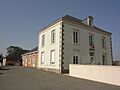
The town hall (mairie) of Mont-Saint-Jean, where local government decisions are made.
-
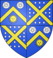
The coat of arms for Mont-Saint-Jean, a symbol representing the commune.
See also
 In Spanish: Mont-Saint-Jean (Sarthe) para niños
