Montagu Land District facts for kids
Quick facts for kids MontaguTasmania |
|||||||||||||||
|---|---|---|---|---|---|---|---|---|---|---|---|---|---|---|---|

Location in Tasmania
|
|||||||||||||||
|
|||||||||||||||
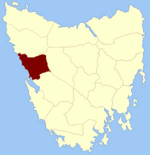
The Montagu Land District (sometimes called Montague) is a special area in Tasmania, Australia. It's one of twenty "land districts" that help divide the state for official reasons. Think of it like a big, invisible boundary line on a map.
These land districts are part of something called "cadastral divisions." This is just a fancy way of saying how land is officially measured and recorded. It helps with things like property ownership and mapping.
Where is Montagu Land District?
The Montagu Land District is located on the west coast of Tasmania. It has some interesting natural borders. To the south, it meets the large body of water known as Macquarie Harbour. To the north, its boundary is the Pieman River.
Key Features of Montagu's Geography
This land district is known for its rugged and wild landscape. The west coast of Tasmania is famous for its dense forests, mountains, and unique wildlife.
Part of the well-known town of Queenstown is also found within the Montagu Land District. However, only the parts of Queenstown that are west of the Queen River belong to Montagu.
Why are Land Districts Important?
Land districts like Montagu help the government and people understand exactly where land is located. They are used for:
- Mapping out areas.
- Keeping track of land ownership.
- Planning for new developments.
Long ago, Montagu was even called one of the 18 "counties" of Tasmania. This shows how these divisions have been used for a long time to organize the land.
 | Bayard Rustin |
 | Jeannette Carter |
 | Jeremiah A. Brown |

