
Montchauvet, Calvados facts for kids
Quick facts for kids
Montchauvet
|
|
|---|---|

Menhirs of Plumaudière
|
|

Montchauvet
Location in France

Montchauvet
Location in Normandy
|
|
| Country | France |
| Region | Normandy |
| Department | Calvados |
| Arrondissement | Vire |
| Canton | Condé-sur-Noireau |
| Area
1
|
18.21 km2 (7.03 sq mi) |
| Population
(2008)
|
362 |
| • Density | 19.88/km2 (51.49/sq mi) |
| Time zone | UTC+01:00 (CET) |
| • Summer (DST) | UTC+02:00 (CEST) |
| INSEE/Postal code |
14443 /14350
|
| Elevation | 145–293 m (476–961 ft) |
| 1 French Land Register data, which excludes lakes, ponds, glaciers > 1 km2 (0.386 sq mi or 247 acres) and river estuaries. | |
Montchauvet was a small French town, also known as a commune. It was located in the Basse-Normandie region of northwest France. Montchauvet was part of the Calvados department.
On January 1, 2016, Montchauvet joined with other nearby towns. They formed a new, larger commune called Souleuvre-en-Bocage. This means Montchauvet is no longer a separate commune on its own.
Contents
Where Was Montchauvet?
Montchauvet was found in the northwest part of France. It was in the region known as Basse-Normandie. This area is famous for its green landscapes and history.
Calvados Department
The town was located in the Calvados department. A department is like a county or a state in other countries. Calvados is known for its apple orchards and cider.
What Is a Commune?
In France, a commune is the smallest area of local government. It is like a town or a village. Each commune has its own mayor and local council. They manage local services for the people living there.
Why Communes Merge
Sometimes, smaller communes like Montchauvet join together. This happens to create larger towns. It can help them share resources and services better. It also makes local government more efficient.
Images for kids
-
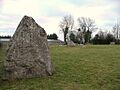
Menhirs of Plumaudière
See also
 In Spanish: Montchauvet (Calvados) para niños
