Monte Caburaí facts for kids
Quick facts for kids Monte Caburaí |
|
|---|---|
| Highest point | |
| Elevation | 1,465 m (4,806 ft) |
| Geography | |
| Location | Roraima, Brazil - Guyana |
Monte Caburaí is a mountain located on the border between the South American countries of Brazil and Guyana. It stands tall at about 1,465 meters (or 4,806 feet) above sea level. This mountain is very special because it holds the source of the Ailã River.
Contents
What Makes Monte Caburaí Special?
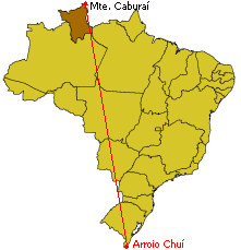
Monte Caburaí is famous for being the northernmost point of Brazil. This means it is the furthest north you can go in the entire country! The Ailã River starts its journey right here on the mountain.
Where is Monte Caburaí Located?
This important mountain sits right on the border between Brazil and Guyana. It is found in the Brazilian state of Roraima. Its exact location is 05°16′20″N 60°12′43″W / 5.27222°N 60.21194°W.
Why is Monte Caburaí Important for Brazil?
Monte Caburaí marks one of Brazil's "extreme points." These are the very edges of the country in each direction (north, south, east, and west). Knowing these points helps us understand the full size and shape of Brazil.
Learn More
- In Spanish: Monte Caburaí para niños
- Extreme points of Brazil
 | John T. Biggers |
 | Thomas Blackshear |
 | Mark Bradford |
 | Beverly Buchanan |


