Montgardin facts for kids
Quick facts for kids
Montgardin
|
||
|---|---|---|

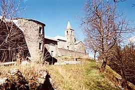
A view of the church in the village of Montgardin
|
||
|
||
| Country | France | |
| Region | Provence-Alpes-Côte d'Azur | |
| Department | Hautes-Alpes | |
| Arrondissement | Gap | |
| Canton | Chorges | |
| Intercommunality | Avance | |
| Area
1
|
15.32 km2 (5.92 sq mi) | |
| Population
(Jan. 2019)
|
457 | |
| • Density | 29.83/km2 (77.26/sq mi) | |
| Time zone | UTC+01:00 (CET) | |
| • Summer (DST) | UTC+02:00 (CEST) | |
| INSEE/Postal code |
05084 /05230
|
|
| Elevation | 772–1,420 m (2,533–4,659 ft) (avg. 839 m or 2,753 ft) |
|
| 1 French Land Register data, which excludes lakes, ponds, glaciers > 1 km2 (0.386 sq mi or 247 acres) and river estuaries. | ||
Montgardin is a small village, also known as a commune, located in the Hautes-Alpes department in France. A commune is like a local government area, similar to a town or parish. The Hautes-Alpes department is a region in southeastern France, known for its mountains.
About Montgardin
Montgardin is a quiet place with a small population. As of January 2019, about 457 people lived there. The village is nestled in an area with varying heights, from 772 meters (about 2,533 feet) to 1,420 meters (about 4,659 feet) above sea level. The main part of the village is around 839 meters high.
How People Get Around
Several roads help people travel to and from Montgardin. These include the D93, D93L, D614, D942, and N94 roads. These roads connect Montgardin to other nearby towns and areas.
See also
 In Spanish: Montgardin para niños


