Moscow State University of Geodesy and Cartography facts for kids
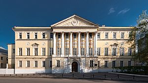
The Moscow State University of Geodesy and Cartography (often called MIIGAiK) is a famous university in Russia. It is one of the oldest schools in the world that teaches about geodesy and cartography. This university was started a long time ago in 1779. Today, it has six main departments, called faculties, where students learn many different things.
Contents
What is MIIGAiK?
MIIGAiK stands for Moscow State University of Geodesy and Cartography. It is a special place where students learn how to measure the Earth and make maps. This university is located in Moscow, the capital city of Russia. It has been teaching these important skills for over 240 years.
What is Geodesy?
Geodesy is a science that studies the Earth's shape and size. It also looks at how the Earth's gravity works. People who work in geodesy use special tools to measure distances and angles very accurately. They help us understand how mountains, valleys, and even continents are shaped. Geodesy is important for building roads, bridges, and even for space travel.
What is Cartography?
Cartography is the art and science of making maps. Maps help us find our way around and understand different places. Cartographers use information from geodesy and other sources to draw maps. They decide what information to show and how to show it clearly. Today, cartographers use computers to create digital maps, like the ones on your phone or in your car.
A Look at MIIGAiK's History
MIIGAiK started in 1779. It was first known as the Surveying School. This school was very important because Russia needed skilled people to measure its vast lands and create accurate maps.
Early Beginnings
The school was founded by the Russian government. Its main goal was to train land surveyors. These surveyors would measure land for farming, building, and managing the country. This made it one of the first schools in the world focused on these subjects.
Growing and Changing
Over the years, the school grew and changed its name several times. It became a university and started teaching more advanced topics. It always focused on geodesy and cartography. Many famous scientists and engineers have studied or taught at MIIGAiK. They helped develop new ways to measure the Earth and make maps.
What Students Learn Today
Today, MIIGAiK offers many different programs. Students can learn about traditional mapping and modern technologies. The university has six main faculties, each focusing on a different area of study.
Main Study Areas
- Geodesy: Students learn about Earth's measurements, satellite navigation (like GPS), and land surveying.
- Cartography: This area teaches how to design, create, and use maps. It includes digital mapping and geographic information systems (GIS).
- Optics and Laser Technology: Some students learn about light and lasers. These are used in many modern measuring tools.
- Applied Cosmonautics: This field combines space technology with Earth observation. Students learn how satellites help us map the Earth.
- Economics and Management: This faculty teaches how to manage projects related to land and mapping.
- Humanities: Students also study subjects like history and languages. This helps them become well-rounded professionals.
Why MIIGAiK is Important
MIIGAiK plays a big role in Russia and around the world. It trains experts who help us understand our planet better.
Contributions to Society
The graduates of MIIGAiK work in many important fields. They help create accurate maps for navigation and urban planning. They also work on projects involving land management and environmental protection. Their skills are vital for building new cities and managing natural resources.
Research and Innovation
The university is also a center for new ideas. Researchers at MIIGAiK work on advanced projects. They develop new technologies for measuring and mapping. This includes using drones, satellites, and advanced computer programs. Their work helps improve how we see and understand the world.
 | Misty Copeland |
 | Raven Wilkinson |
 | Debra Austin |
 | Aesha Ash |


