Mount Adolphus Island facts for kids
|
Native name:
Muri or Mori
|
|
|---|---|

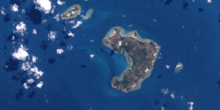
A satelitte image of Mount Adolphus Island
|
|

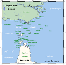
A map of the Torres Strait Islands showing Mount Adolphus Island in the southeast waters of Torres Strait
|
|
| Geography | |
| Location | Adolphus Channel, Cape York Peninsula, Northern Australia |
| Coordinates | 10°38′13″S 142°39′07″E / 10.637°S 142.652°E |
| Archipelago | Torres Strait Islands |
| Adjacent bodies of water | Torres Strait |
| Total islands | 1 |
| Area | 6.74 km2 (2.60 sq mi) |
| Length | 4.4 km (2.73 mi) |
| Width | 2.1 km (1.3 mi) |
| Highest elevation | 150 m (490 ft) |
| Highest point | Mount Adolphus |
| Administration | |
|
Australia
|
|
| State | Queensland |
| Local government area | Shire of Torres |
Mount Adolphus Island, also known as Muri or Mori in the local language, is an island that belongs to the Torres Strait Islands. An archipelago is a group of many islands. This island is located at the very top of Cape York Peninsula in Queensland, Australia.
It sits on the northern side of the Adolphus Channel. It is across from Albany Island and about 40 kilometers (25 miles) northeast of Bamaga.
Contents
Exploring Mount Adolphus Island's Geography
Mount Adolphus Island is about 4.4 kilometers (2.7 miles) long. At its widest point, it measures 2.1 kilometers (1.3 miles) across. The island covers an area of 6.74 square kilometers (2.6 square miles). It is located 10.1 kilometers (6.3 miles) away from the Australian mainland.
The highest point on the island is a flat-topped hill called Mount Adolphus. This peak reaches a height of 178 meters (584 feet) above sea level.
What Coastal Features Can You Find?
Mount Adolphus Island has several interesting coastal features. These include smaller islands and points of land around its edges:
- Lacey Island
- Little Adolphus Island
- Salter Island
- Nicklin Islet
- North East Bluff
- Morilug Islet, also known as Tiakan Islet
- Akone Islet
- Pinnacle Peak
- Cambridge Point
- Dickey Point
- Blackwood Bay
A Glimpse into Mount Adolphus Island's History
The area around Mount Adolphus Island has a rich history. The Djagaraga people are the traditional owners of the land. Their language, also known as Yadhaigana, Dyagaraga, and Yagulleone, comes from the tip of Cape York Peninsula.
Traditionally, this language was spoken on Eastern Cape York. This includes places like Albany Island and Mount Adolphus Island.
Shipwrecks Near Mount Adolphus Island
The waters around Mount Adolphus Island have seen some shipwrecks over the years.
The Aliquis Shipwreck (1839)
The ship Aliquis, led by Captain Gill, was sailing from Port Jackson (near Sydney) to Calcutta (in India). In May 1839, it was lost near Mount Adolphus Island. Luckily, no one died in this incident. The crew members were rescued by another ship called the Argyle.
The Quetta Shipwreck (1890)
The Quetta was a large iron steamship built in Scotland in 1881. It was owned by the British India Steam Navigation Company and captained by Alfred Sanders. On February 6, 1890, the ship was traveling from Brisbane to London.
On February 28, 1890, the Quetta hit an uncharted coral reef in Mount Adolphus Channel. The hidden rock tore through six parts of the ship's hull. Water rushed in, causing the boilers to explode and flooding the lower decks. The ship quickly tilted at a 45-degree angle. In less than five minutes after hitting the rock, the Quetta sank beneath the waves. Sadly, 134 people lost their lives, but 158 people survived.
 | Georgia Louise Harris Brown |
 | Julian Abele |
 | Norma Merrick Sklarek |
 | William Sidney Pittman |

