Mount Aetna, Pennsylvania facts for kids
Quick facts for kids
Mount Aetna, Pennsylvania
|
||
|---|---|---|

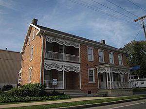
House in Mount Aetna
|
||
|
||
| Country | United States | |
| State | Pennsylvania | |
| County | Berks | |
| Township | Tulpehocken | |
| Area | ||
| • Total | 0.50 sq mi (1.28 km2) | |
| • Land | 0.49 sq mi (1.28 km2) | |
| • Water | 0.00 sq mi (0.00 km2) | |
| Population
(2020)
|
||
| • Total | 489 | |
| • Density | 987.88/sq mi (381.55/km2) | |
| Time zone | UTC-5 (Eastern (EST)) | |
| • Summer (DST) | UTC-4 (EDT) | |
| ZIP codes |
19544
|
|
| FIPS code | 42-51320 | |
Mount Aetna is a small community in Pennsylvania, United States. It is known as a census-designated place. This means it's an area that the government counts for population, but it doesn't have its own separate local government like a city or town.
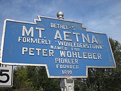
Mount Aetna is located in Berks County. It is found along Pennsylvania Route 501, very close to the border of Lebanon County. The community gets its name from a famous active volcano called Mount Etna. This volcano is located in Sicily, Italy.
Who Lives in Mount Aetna?
Mount Aetna is a small community. In 2010, about 354 people lived there. By 2020, the population had grown to 489 residents.
| Historical population | |||
|---|---|---|---|
| Census | Pop. | %± | |
| 2020 | 489 | — | |
| U.S. Decennial Census | |||
Where is Mount Aetna?
Mount Aetna is in Tulpehocken Township. This township is part of Berks County in Pennsylvania. It's a quiet area with homes and open spaces.
Why the Name Mount Aetna?
The name "Mount Aetna" comes from Mount Etna, a very famous volcano in Italy. It's interesting that a small place in Pennsylvania is named after such a powerful natural landmark!
See also
 In Spanish: Mount Aetna (Pensilvania) para niños
 | Anna J. Cooper |
 | Mary McLeod Bethune |
 | Lillie Mae Bradford |


