
Mount Bonnell facts for kids
|
Covert Park at Mount Bonnell
|
|

View of Lake Austin from the summit of Mount Bonnell
|
|

Mount Bonnell
Location in Texas

Mount Bonnell
Location in the United States
|
|
| Location | 3800 Mount Bonnell Rd Austin, Texas 78731 |
|---|---|
| Area | 5.36 acres (2.17 ha) |
| Built | June 2, 1939 |
| NRHP reference No. | 15000619 |
Quick facts for kids Significant dates |
|
| Added to NRHP | September 17, 2015 |
Mount Bonnell, also known as Covert Park, is a famous spot in Austin, Texas. It sits next to Lake Austin, which is part of the Colorado River. People have loved visiting Mount Bonnell since the 1850s.
From the top, you can see amazing views of Austin, Lake Austin, and the hills around it. In 1969, it became a Recorded Texas Historic Landmark. Later, in 2015, it was added to the National Register of Historic Places.
Contents
Discovering Mount Bonnell's Location
Mount Bonnell is located at 30.3210°N, 97.7736°W. Its peak is about 775 feet above sea level. Some people used to think it was the highest point in Austin.
However, other areas within Austin are actually higher. Still, Mount Bonnell offers one of the best public views of the city.
A Look Back: Mount Bonnell's History
The Story Behind the Name
Mount Bonnell is believed to be named after George W. Bonnell. He was an early newspaper publisher in Texas. George Bonnell moved to Texas in 1836.
He published a local paper called The Texas Sentinel. He was also important in early Texas and Travis County (Austin) after the Texas Revolution.
There's also a legend about the name. It says Mount Bonnell was once called Antoinette's Leap. This was after a young woman named Antoinette. The story says she jumped to her death to avoid being captured by Native Americans. They had just killed her fiancé.
Early Days: Indian Trails and Pioneers
In 1969, a historical marker was placed at Mount Bonnell. It shares some interesting facts about the area. The marker says the mountain is 775 feet above sea level. It was named for George W. Bonnell, who fought for Texas independence.
He was also a commissioner for Indian affairs. He published a newspaper in Austin in 1840.
A frontiersman named W.A.A. "Bigfoot" Wallace had an adventure here in 1839. He met a Native American on a narrow ledge and had a fight. Wallace also hid in a cave on Mount Bonnell to recover from an illness. He was gone so long that his sweetheart married someone else!
In the mid-1800s, Mormons built a mill near the base of Mount Bonnell. A flood destroyed the mill, and the Mormons moved west. Mount Bonnell became a popular spot for picnics and outings in the 1850s and 1860s. It still is today.
A popular song, "Wait for the Wagon and We'll All Take a Ride," might have been inspired by a trip to Mount Bonnell in the 1850s. In 1898, a woman named Miss Hazel Keyes even slid down a cable from the top of the mountain to the lake below as a stunt.
Bigfoot Wallace later explained why he chose the cave as a hiding spot. He said it was on an old Native American trail leading to Austin. He also mentioned it was a great place to hunt for bears.
Julia Lee Sinks and the Trails
Julia L. Sinks was a writer and historian. She moved to Austin in 1840. She lived on West Pecan, which is now 6th Street. She wrote about her home being on a path used by Native Americans.
This path led into town from Mount Bonnell. She said the path was hidden and not used by white settlers at night. Native Americans claimed it as their route, and moccasin tracks were common during full moons.
Historical Events on the Trail
Mount Bonnell was part of trails both into and out of Austin. In 1842, a historical event happened near here. A woman named Mrs. Simpson lived on West Pecan Street. Her two children, a 14-year-old daughter and a 12-year-old son, were taken by Native Americans. This happened while they were in a nearby valley.
The Native Americans took the children and rode towards the mountains, heading in the direction of Mount Bonnell. A group of citizens chased after them. They almost caught up near Mount Bonnell. However, the Native Americans went to the top of the rocky mountain, and the citizens lost their trail.
The Simpson boy survived and was later returned to his mother. He shared what happened after the chase. From Mount Bonnell, they stopped at Spicewood Springs. This is about 5 miles north of Mount Bonnell today.
Understanding Mount Bonnell's Rocks
Mount Bonnell is part of the Balcones Fault Escarpment. This is a long slope or cliff formed by a fault line. These "balconies" were first described in 1756.
The mountain is mostly made of limestone. This type of rock is common in the area. The Mount Bonnell fault is a significant normal fault in this region. It has caused the ground to shift vertically by up to 600 feet.
Images for kids
-
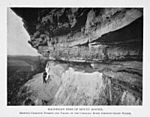
Outcrop at Mount Bonnell (Hill, 1889)
-
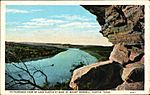
1917 postcard depiction of view from Mount Bonnell
-
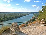
View from the summit
-
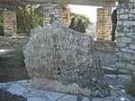
An engraved rock at the top of Mount Bonnell
-
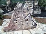
The engraved rock as it appears today
-
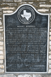
Texas Historical Marker at Mount Bonnell
-
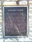
Covert Park Marker at foot of Mount Bonnell


