
Mount Donna Buang facts for kids
Quick facts for kids Mount Donna Buang |
|
|---|---|

Mount Donna Buang
Location in Victoria
|
|
| Highest point | |
| Elevation | 1,250 metres (4,100 ft) AHD |
| Geography | |
| Location | Victoria, Australia |
| Parent range | Donna Buang Range, Victorian Alps, Great Dividing Range |
Mount Donna Buang is a cool mountain located in Victoria, Australia. It's part of the Victorian Alps and the larger Great Dividing Range. This mountain is about 80 kilometres (50 mi) from Melbourne and stands 1,250 metres (4,101 ft) tall. It's special because it's the closest place to Melbourne where you can find snow!
Contents
Fun Activities at Mount Donna Buang
Mount Donna Buang is a great spot for outdoor fun all year round.
Winter Snowplay
In winter, the mountain often gets enough snow for exciting snowplay and tobogganing. It's a popular place for families to enjoy the snow without traveling too far.
Exploring the Outdoors
During the warmer months, many people visit Mount Donna Buang for bushwalking and cycling. The fresh air and beautiful scenery make it perfect for exploring.
Mount Donna Buang Skywalk
At the top of Mount Donna Buang, you'll find tall alpine ash and snow gum trees. Near Cement Creek, there's a special canopy walkway called the Mount Donna Buang Skywalk. It lets you walk high up through the treetops, giving you an amazing view of myrtle beech and mountain ash trees.
Mount Donna Buang is part of the Yarra Ranges National Park, which was created in 1995. The closest town with services is Warburton.
Plants and Animals of Mount Donna Buang
The mountain is home to many different plants and animals.
Forests and Trees
The lower and middle parts of the mountain have very tall forests of mountain ash trees. In cooler, sheltered areas, you can find cool temperate rainforests. Here, trees like myrtle beech, sassafras, and soft tree ferns grow. You might also see large shrubs like hazel pomaderris.
Higher up the mountain, closer to the summit, you'll find sub-alpine trees like woollybutt and snowgum. Myrtle beech trees also grow almost all the way to the top.
Wildlife and Unique Species
Mount Donna Buang is home to many native animals. This includes the rare Leadbeater's possum, a small marsupial. About 120 different kinds of native birds live here too, such as the pink robin, yellow-tailed black cockatoo, and the crimson rosella.
A very special insect called the Mount Donna Buang wingless stonefly lives only in this area. This means it is endemic to Mount Donna Buang.
History of Mount Donna Buang
Mount Donna Buang has an interesting past, from its name to its role as a popular resort.
Naming the Mountain
In the 1860s, a police magistrate named Joseph Anderson Panton called the mountain "Mount Acland." However, its current name, "Mount Donna Buang," likely comes from the Wurundjeri Aboriginal people.
Early Tracks and Roads
A walking track to the summit was created in the 1890s. Later, in 1912, a much wider path called the Donna Buang Bridle Track was opened. The road from Warburton to the top of Mount Donna Buang still follows this old track today.
Sadly, in 1911, federal government minister Lee Batchelor passed away while climbing Mount Donna Buang.
Timber and Logging History
From the early 1900s to the mid-1920s, timber was harvested from the mountain. Seven cable tramways were used to move logs from the Ben Cairn - Donna Buang ridge down to sawmills near Warburton. Even though the forest has grown back and looks untouched, you can still find old tram rails and cables in the forest.
Mount Donna Buang as a Ski Resort
From 1925 to the early 1950s, Mount Donna Buang was a popular ski resort. It had four ski lodges, cafes, a ski hire shop, a ski jump, and six ski runs cut through the forests. For over 20 years, thousands of visitors came every snowy weekend. However, the ski runs were quite short, and the snow wasn't always reliable. After World War II, better transport meant people started going to higher ski resorts further from Melbourne. Even so, Mount Donna Buang remained a favorite spot for families to play in the snow.
Cycling Challenges
The road from Warburton to Mount Donna Buang is a challenging route for cyclists. It goes uphill for about 16.6 km, with an average slope of 6.2%. This makes it a popular training route for endurance cyclists and triathletes in the summer. It's also a favorite for recreational driving and motorcycling.
The main public roads on Mount Donna Buang include:
- Donna Buang Road: This road is sealed (paved) from Warburton to just past the Mount Donna Buang Summit Road junction.
- Acheron Way: This road joins Donna Buang Road about halfway up the mountain and leads to Marysville. Most of it is sealed, except for a 12-kilometer section in the middle.
- Don Road: This road runs from Healesville to the Warburton Highway. It connects with Donna Buang Road but is unsealed (unpaved) for much of its length.

Images for kids
-
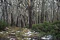
Eucalyptus trees at Mount Donna Buang
-
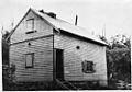
One of the ski lodges on Mt Donna Buang in the 1930s. Photo by Kath Magill.
-
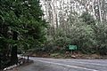
The road up to Mount Donna Buang


