Mount Jewett, Pennsylvania facts for kids
Quick facts for kids
Mount Jewett, Pennsylvania
|
|
|---|---|
|
Borough
|
|

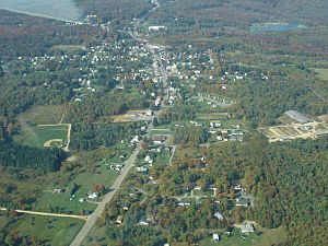
A birdseye view of Mt. Jewett (click to enlarge)
|
|

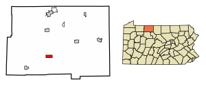
Location of Mount Jewett in McKean County, Pennsylvania.
|
|
| Country | United States |
| State | Pennsylvania |
| County | McKean |
| Incorporated | 1893 |
| Area | |
| • Total | 2.42 sq mi (6.28 km2) |
| • Land | 2.40 sq mi (6.23 km2) |
| • Water | 0.02 sq mi (0.05 km2) |
| Elevation | 2,240 ft (680 m) |
| Population
(2020)
|
|
| • Total | 858 |
| • Density | 356.76/sq mi (137.74/km2) |
| Time zone | UTC-5 (Eastern (EST)) |
| • Summer (DST) | UTC-4 (EDT) |
| Zip code |
16740
|
| Area code(s) | 814 |
| FIPS code | 42-51632 |
Mount Jewett is a small town, called a borough, in McKean County, Pennsylvania, United States. In 2020, about 849 people lived there. Students from Mount Jewett go to school in the Kane Area School District. This is interesting because the town is surrounded by Hamlin Township, which belongs to a different school district.
Mount Jewett is very close to the famous Kinzua Bridge State Park. This park is home to the Kinzua Bridge Sky Walk and the Kinzua Viaduct. The current mayor of Mount Jewett is Brianna Howard.
Contents
Geography and Climate
Mount Jewett is located at coordinates 41°43′29″N 78°38′37″W.
The United States Census Bureau says the borough covers about 2.4 square miles (6.2 square kilometers) of land. There is almost no water area.
Mount Jewett is one of the highest towns in Pennsylvania. It shares the title of being the fifth-highest town with Callimont. Its elevation is 2,240 feet (683 meters) above sea level.
Mount Jewett's Weather
Mount Jewett has a humid continental climate. This means it has big changes in temperature throughout the year. Summers are warm to hot and often humid. Winters are cold, and sometimes very cold. This type of climate is known as "Dfb" on climate maps.
Population and People
| Historical population | |||
|---|---|---|---|
| Census | Pop. | %± | |
| 1900 | 1,553 | — | |
| 1910 | 1,771 | 14.0% | |
| 1920 | 1,494 | −15.6% | |
| 1930 | 1,379 | −7.7% | |
| 1940 | 1,445 | 4.8% | |
| 1950 | 1,415 | −2.1% | |
| 1960 | 1,226 | −13.4% | |
| 1970 | 1,060 | −13.5% | |
| 1980 | 1,053 | −0.7% | |
| 1990 | 1,029 | −2.3% | |
| 2000 | 1,070 | 4.0% | |
| 2010 | 919 | −14.1% | |
| 2020 | 849 | −7.6% | |
| 2021 (est.) | 837 | −8.9% | |
| Sources: | |||
In 2000, there were 1,070 people living in Mount Jewett. They lived in 444 households, with 305 of these being families. The population density was about 449 people per square mile (173 people per square kilometer).
Most of the people living in Mount Jewett are White. A small number are Native American or Asian.
About 34.7% of households had children under 18 living with them. The average household had 2.41 people. The average family had 2.90 people.
The population includes people of all ages. About 27.1% were under 18 years old. About 14.6% were 65 years or older. The average age in Mount Jewett was 35 years old.
Things to See and Do
The Kinzua Bridge State Park
The Kinzua Bridge State Park is just a few miles north of Mount Jewett. This park is famous for its bridge, which once carried trains across the Kinzua valley. The bridge was built in 1882 and was the highest iron bridge in the world. It was later rebuilt with steel in 1900.
After it became a state park, a company used the bridge for tourist train rides. People could ride an old steam locomotive across the valley. Sadly, on July 21, 2003, a strong tornado destroyed a large part of the bridge. Now, only a section of the bridge remains, along with small parts of the railroad tracks.
In 2008, the locomotives used for the tourist rides were badly damaged by a fire. This made it even harder to dream of rebuilding the bridge.
The state decided not to rebuild the Kinzua Bridge because it would have cost too much money. Instead, the broken parts of the bridge became a special visitor attraction. They show how powerful nature can be. Before the collapse, the park attracted about 215,000 visitors each year. It was even named one of Pennsylvania's "Twenty Must-See State Parks."
The story of the viaduct and its collapse was shown on the History Channel's show Life After People. It was used as an example of how steel structures can eventually fall apart due to rust and strong winds.
The Knox and Kane Railroad had to stop its train rides in 2004. This was because fewer people visited after the Kinzua Bridge collapsed. Another company bought the railroad's tracks and trains.
In 2005, Pennsylvania planned to spend money to fix the remaining parts of the bridge and build new park facilities. The Kinzua Sky Walk opened on September 15, 2011. This is a special walkway that leads to an observation deck. The deck has a glass floor, so you can look straight down into the valley! The Sky Walk cost $4.3 million to build. It is expected to bring in a lot of money from tourism for the area.
Other Local Highlights
- In February 2001, an event at the Temple Inland particle board plant in Mount Jewett caused a significant incident, affecting several workers.
- Many people in Mount Jewett have Swedish family roots. Every August, the town celebrates this history with its popular "Swedish Festival." The 2010 festival was the 40th one. The 2021 festival was the 50th, as the 2020 event was canceled due to the global COVID-19 pandemic.
- Mount Jewett was named after Hugh Judge Jewett. He was the president of the New York, Lake Erie and Western Railroad. This railroad brought train service to the area. Before that, the town was called Howard Hill. It was named after Howard, New York.
See also
 In Spanish: Mount Jewett para niños
 | Dorothy Vaughan |
 | Charles Henry Turner |
 | Hildrus Poindexter |
 | Henry Cecil McBay |


