Mount Magnet, Western Australia facts for kids
Quick facts for kids Mount MagnetWestern Australia |
|||||||||
|---|---|---|---|---|---|---|---|---|---|

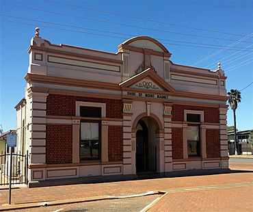
Mt Magnet Shire Office b.1898
|
|||||||||
| Postcode(s) | 6638 | ||||||||
| Elevation | 426 m (1,398 ft) | ||||||||
| Area | [convert: needs a number] | ||||||||
| Location | |||||||||
| LGA(s) | Shire of Mount Magnet | ||||||||
| Region | Mid West | ||||||||
| State electorate(s) | North West | ||||||||
| Federal Division(s) | Durack | ||||||||
| Website | Mount Magnet | ||||||||
|
|||||||||
Mount Magnet is a town in the Mid West region of Western Australia. It is one of the oldest gold mining towns in the area. In fact, it is the longest-lasting gold mining settlement in the entire state.
In 1854, an explorer named Robert Austin saw a big hill next to where the town is now. He called it West Mount Magnet. He had already named a smaller hill 64 kilometers away East Mount Magnet. Both hills had a lot of iron in them. This iron made his compass act strangely! In 1972, the big hill got its original Aboriginal name back: "Warramboo." This name means "campfire camping place." What's cool is that at Mount Magnet, a compass points exactly to true north.
Contents
Discovering Mount Magnet's Gold
Around Mount Magnet, you can still see signs of old gold mining. To the north-east, there are important Aboriginal sites. The local community and the Western Australian Museum are working together to protect these sites.
The town's history is kept alive at the Wirnda Barna Arts Centre. You can also learn a lot at the Mount Magnet Mining and Pastoral Museum.
Long ago, there were three separate towns in this area. They were Mount Magnet, Boogardie, and Lennonville. A mining company started digging for gold at a place called Hill 50 in 1936. Over time, the open-pit mining at Hill 50 grew so much that it covered the old town of Boogardie.
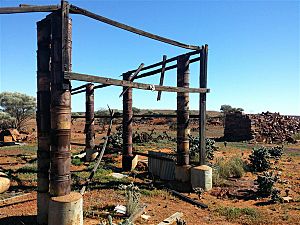
Lennonville was left empty when World War I began. You can still see the old foundations of the bank and train station there.
Modern Gold Mining
Gold mining is still active in the Mount Magnet area today. A company called Ramelius Resources bought Mt Magnet Gold Pty Ltd in 2010. They operate the Saturn and Mars pits, which are part of the Galaxy mining area.
In 2015, the company also started new digging at the Perseverance open pit. This pit is at the top of the Hill 50 underground mine. Hill 50 is about 4 kilometers north-west of Mount Magnet.
It's unusual for a big mining town like Mount Magnet, but it never had its own public battery. A battery is a machine that crushes rock to get the gold out. The closest one was built 5 kilometers west in Boogardie. You can now see this old battery at the Mount Magnet Mining and Pastoral Museum.
Mount Magnet's main street is very wide. It has three hotels and many historic buildings. These show how busy the town was during the gold rush days.
Nature and Travel
From August to November, the Gascoyne-Murchison area is beautiful. Tourists come to see the many wildflowers. You can find thousands of different wildflowers and plants. Some famous ones include the bright red Sturt's desert pea and the purple mulla mulla. You can also see fields of white, yellow, and pink everlastings.
Mount Magnet was once an important railway stop. This was when the Northern Railway went to Meekatharra. The Sandstone branch railway also connected here.
Today, Mount Magnet has its own airport. Skippers Aviation offers flights to and from Meekatharra and Perth.
Mount Magnet's Climate
Mount Magnet has a desert climate. This means it is very dry. The average highest temperature in Mount Magnet is 28.6 degrees Celsius. The driest months are from September to November. During these months, the average rainfall is only about 8.93 millimeters. The hottest day ever recorded in Mount Magnet was 47.4 degrees Celsius. This happened on January 21, 2015.
| Climate data for Mount Magnet Aero | |||||||||||||
|---|---|---|---|---|---|---|---|---|---|---|---|---|---|
| Month | Jan | Feb | Mar | Apr | May | Jun | Jul | Aug | Sep | Oct | Nov | Dec | Year |
| Record high °C (°F) | 47.4 (117.3) |
45.9 (114.6) |
42.0 (107.6) |
37.5 (99.5) |
35.1 (95.2) |
28.0 (82.4) |
27.9 (82.2) |
32.0 (89.6) |
35.6 (96.1) |
40.6 (105.1) |
43.6 (110.5) |
45.4 (113.7) |
47.4 (117.3) |
| Mean daily maximum °C (°F) | 37.9 (100.2) |
36.8 (98.2) |
32.9 (91.2) |
28.8 (83.8) |
23.8 (74.8) |
19.9 (67.8) |
18.8 (65.8) |
21.4 (70.5) |
24.7 (76.5) |
29.6 (85.3) |
32.6 (90.7) |
35.7 (96.3) |
28.6 (83.5) |
| Mean daily minimum °C (°F) | 23.5 (74.3) |
23.3 (73.9) |
20.1 (68.2) |
16.2 (61.2) |
11.7 (53.1) |
8.3 (46.9) |
7.0 (44.6) |
8.0 (46.4) |
10.4 (50.7) |
14.6 (58.3) |
17.9 (64.2) |
21.1 (70.0) |
15.2 (59.4) |
| Record low °C (°F) | 12.6 (54.7) |
13.5 (56.3) |
9.9 (49.8) |
5.1 (41.2) |
3.3 (37.9) |
0.5 (32.9) |
−0.2 (31.6) |
0.5 (32.9) |
3.0 (37.4) |
5.3 (41.5) |
8.1 (46.6) |
11.5 (52.7) |
−0.2 (31.6) |
| Average precipitation mm (inches) | 27.7 (1.09) |
35.4 (1.39) |
38.2 (1.50) |
19.7 (0.78) |
18.5 (0.73) |
19.9 (0.78) |
30.0 (1.18) |
16.6 (0.65) |
9.0 (0.35) |
6.4 (0.25) |
11.4 (0.45) |
21.9 (0.86) |
257.5 (10.14) |
| Average precipitation days | 4.8 | 5.0 | 4.8 | 4.8 | 5.0 | 6.1 | 7.8 | 5.7 | 4.1 | 3.0 | 3.2 | 3.7 | 58.0 |
| Average relative humidity (%) | 35 | 41 | 45 | 53 | 57 | 66 | 68 | 60 | 51 | 39 | 36 | 34 | 49 |
| Source: Bureau of Meteorology | |||||||||||||
 | Kyle Baker |
 | Joseph Yoakum |
 | Laura Wheeler Waring |
 | Henry Ossawa Tanner |


