
Mount Manaia facts for kids
Quick facts for kids Mount Manaia |
|
|---|---|

Mt Manaia viewed from coastal Taurikura
|
|
| Highest point | |
| Elevation | 420 m (1,380 ft) |
| Isolation | 6.67 km (4.14 mi) |
| Naming | |
| Native name | Manaia (Māori) |
| Geography | |

Mount Manaia
Location in Northland Region
|
|
| Climbing | |
| Easiest route | Mount Manaia Track |
Mount Manaia is a really cool mountain in New Zealand. It's about 30 kilometers southeast of Whangarei city. You can find it on the Whangarei Heads peninsula. This mountain stands tall at 420 meters (about 1,378 feet). It's a famous landmark in the area.
Contents
About Mount Manaia
Mount Manaia is a very noticeable landmark. It's located near Whangarei city in New Zealand. The mountain is part of the beautiful Whangarei Heads peninsula. It reaches 420 meters (1,378 feet) into the sky.
Amazing Views from the Top
If you climb to the top of Mount Manaia, you'll see incredible sights! You can look out over the Marsden Point Oil Refinery. You'll also see Bream Bay and the Hauraki Gulf to the south. To the west, you can spot Whangarei Harbour. Looking north, you might see the Poor Knights Islands and the Northland coast.
How Mount Manaia Was Formed
Mount Manaia, along with nearby Mt Lion and Bream Head, are pieces of a huge ancient volcano. This volcano was about 50 kilometers wide! It erupted with great power about 20 million years ago. This happened during a time called the early Miocene period. The jagged shape of Mount Manaia is similar to other old volcanoes in Northland. They all erupted around the same time.
Exploring the Mountain
Today, Mount Manaia is covered in native bush. Its sharp peaks and steep cliffs are protected. They are part of a Department of Conservation reserve. There's a well-kept track that leads to the summit. It takes about 1½ hours to walk to the top. It's a great way to explore the mountain and see its natural beauty.
Photo gallery
-
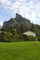
Mt Manaia viewed from Manaia Baptist Camp at Taurikura
-
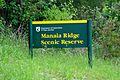
Manaia Ridge Scenic Reserve
-
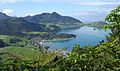
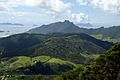
Mt Lion and Taurikura viewed from the flanks of Mt Manaia
-
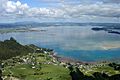
Whangarei Harbour viewed from the summit
-

Looking down at the Marsden Point Oil Refinery from across Whangarei Harbour
-
Bream Head and the Bream Islands viewed from atop the summit
-
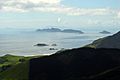
The Bream Islands with Great Barrier Island in the distance viewed from Mt Manaia


