
Mount Spec Road and Little Crystal Creek Bridge facts for kids
Quick facts for kids Mount Spec Road and Little Crystal Creek Bridge |
|
|---|---|

Mount Spec Road over Little Crystal Creek Bridge, 2016
|
|
| Location | Crystal Creek, City of Townsville, Queensland, Australia |
| Design period | 1919 - 1930s (interwar period) |
| Built | 1930-1936 |
| Official name: Mt Spec Road and Little Crystal Creek Bridge | |
| Type | state heritage (built, landscape) |
| Designated | 30 October 2008 |
| Reference no. | 602652 |
| Significant period | 1930s (fabric) 1930s-ongoing (historical use) |
| Lua error in Module:Location_map at line 420: attempt to index field 'wikibase' (a nil value). | |
| Little Crystal Creek Bridge | |
|---|---|

Mount Spec Road crossing Little Crystal Creek Bridge, 2016
|
|
| Coordinates | 19°00′00″S 146°15′02″E / 19.0°S 146.2505°E |
| Carries | Motor vehicles, |
| Crosses | Little Crystal Creek |
| Locale | Paluma, North Queensland, Australia |
| Characteristics | |
| Design | Arch bridge |
| Material | Stone-faced Concrete |
| Number of spans | 1 |
| History | |
| Construction begin | January 1932 |
| Construction end | June 1933 |
The Mount Spec Road and Little Crystal Creek Bridge is a special road and bridge in Queensland, Australia. It is listed as a heritage site, meaning it's an important part of history. The road stretches from Mutarnee to Paluma, and the bridge crosses Little Crystal Creek. This area is about 61 kilometers (38 miles) north of Townsville.
The road and bridge were built between 1930 and 1936. This was during the Great Depression, a time when many people didn't have jobs. The project was part of a plan to help people find work. Today, the road helps people get to the beautiful Paluma Range National Park.
Contents
Building Mount Spec Road: A History
Mount Spec Road is about 18 kilometers (11 miles) long. It goes from the old Bruce Highway up to the town of Paluma. The road climbs about 1,000 meters (3,280 feet) up the Paluma Range. The Little Crystal Creek Bridge is a key part of this road, located about halfway along. It's a popular spot for photos and a favorite place for people from Townsville to visit.
Why Was the Road Built?
People wanted this road for many reasons for over 30 years.
- For Miners and Farmers: It would help tin miners, timber cutters, and farmers get to areas west of Paluma.
- For Tourists: The Paluma Range was known for its beautiful scenery and cooler weather. People wanted to visit it as a tourist spot and a place to relax.
- For Water Supply: Townsville also needed a better water supply, and Mount Spec was seen as a good source.
Early visitors to Paluma used old Aboriginal paths. These were mostly foot tracks, not easy for horses.
Early Interest in Paluma
Tin was found west of Paluma in 1875. This made people realize a good road was needed. By the early 1900s, the Paluma Range was promoted for tourism. People thought it would be a great health resort. In 1913, a businessman named REA McKimmin said Mount Spec was more beautiful than other places he had seen. He also noted the amazing change in climate compared to Townsville.
A tin miner, Phillip Foxlee, wrote to the Queensland Premier in 1925. He described a gorge full of waterfalls and thought it could become a National Park. People liked mountain retreats to escape the summer heat. Mount Spec became a popular weekend spot after World War I. Many visitors walked there, just like the miners.
Roads in Queensland: A New Plan
By 1920, Queensland needed better roads. More cars were on the road, and the economy was growing. Roads were in bad shape because local governments didn't have enough money. Queensland was behind other states in road building.
So, the Queensland Government created the Main Roads Board in 1920. This board would plan and fund new roads and bridges. In 1925, it became the Queensland Main Roads Commission. They set standards for roads and bridges to make sure they were built well.
The Main Roads Act of 1920 shared responsibility for roads between local and state governments. This helped coordinate road building. In 1929-1930, a new type of road was added: Tourist Roads. These roads were meant to open up scenic areas for visitors. Mount Spec Road was one of the first Tourist Roads in Queensland.
Townsville's Role
The Townsville City Council strongly supported building Mount Spec Road. The Mayor, William Herbert Green, saw Mount Spec as a source of water for Townsville. The city's water supply was not enough for its growing population.
Building the road finally happened because the State Government needed to create jobs during the Great Depression. It also provided quick access to the new town planned at Cloudy Clearing (now Paluma).
Building the Road: Hard Work
Construction of Mount Spec Road began in November 1930. The Main Roads Commission surveyed, designed, and oversaw the work. Most workers were unemployed men from the region. This project was the biggest unemployment relief effort in the area.
The project was very labor-intensive and took five years. Working conditions were tough. Workers lived in camps along the road. One large camp, No. 1 Camp, had a pipeworks. The Saddle campsite was very big, housing over 100 workers for three years. Three large ship's water tanks still mark this spot today.
Workers dug sand from creeks for concrete pipes. They cleared thick forests by hand. At first, they only had a few trucks, two tractors, and two air compressors. They blasted through granite with gelignite. Most of the work was done with picks and shovels. Later, they used horse-drawn plows and scoops.
The project was so important that the Queensland Governor, Sir Leslie Wilson, even visited.
Opening the Road and Tourist Facilities
As the road was built, guesthouses and camping grounds appeared. Barrett's Guesthouse served workers and visitors. The first land sales for the new town of Paluma happened in December 1934.
The Mount Spec Tourist Road officially opened on July 18, 1937. The Main Roads Commission also built picnic areas, shelter sheds, and walking tracks. They created scenic lookouts and even a "motor camp" (possibly Australia's first motel) in Paluma in 1937.
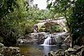
The Beautiful Little Crystal Creek Bridge
The Main Roads Commission cared about how the road looked. The Little Crystal Creek Bridge is a great example of this. Engineers wanted a beautiful stone-faced concrete arch bridge instead of a simpler timber one. They thought a "masonry arch should be considered, as it would harmonise with a rather picturesque spot."
This change was approved in January 1932, even though it cost more. Four stonemasons worked on the bridge. The Commissioner of Main Roads praised the work, saying it showed "the high quality of work which can be achieved by such labour skilfully directed." The Little Crystal Creek Bridge is believed to be the only concrete arch road bridge in Queensland that is still in use today.
Other parts of the road also show this care for beauty. There are smaller concrete arch culverts (tunnels for water) and stone walls along the road.
What You Can See Today

Mount Spec Road is about 18 kilometers (11 miles) long. It goes from the old Bruce Highway to Paluma. The Little Crystal Creek Bridge is about halfway along.
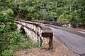
The road is now covered in bitumen, but it still follows its original path. It has never been widened, so it keeps its old character.
Little Crystal Creek Bridge
The Little Crystal Creek Bridge is a single arch bridge. It's made of concrete but has a beautiful stone face. It crosses the Little Crystal Creek Gorge in Paluma Range National Park. It's a very scenic spot and often photographed.
The old campsite used to build the bridge is now a car park. There's a sign with photos telling the history of the area. Some parts of the original stone wall are still there.
Other Features Along the Road
You can see several smaller concrete arch culverts along the road. They are built similarly to the main bridge. There are also sections of dry stone walls and stone-paved gutters. These gutters were built to direct rainwater away from the road.
It's hard to find all the old worker campsites now. However, the location of The Saddle Campsite is marked by three large ship's water tanks. These tanks stored water for the camp.
You can also find a special "Benchmark tree" about 4.8 kilometers (3 miles) from the start of the road. It has a mark from the Main Roads Commission. Some original white-painted timber guideposts are still in Paluma. One section of timber guard rail also remains, showing how the road looked when it was first built.
As you drive up the Paluma Range, you'll see amazing views of Halifax Bay and the coast.
Why is it Heritage Listed?
Mount Spec Road and Little Crystal Creek Bridge were added to the Queensland Heritage Register on October 30, 2008. This means they are important for several reasons:
- History of Queensland: The road shows how North Queensland developed. It was built during the Great Depression to provide jobs. It was a huge project that took six years and employed hundreds of men. It also shows how transport and communication changed in North Queensland, opening up the Paluma Range for tourists, miners, and farmers. It was one of Queensland's first "Tourist Roads."
- Rare Features: The road is still mostly intact. It shows an uncommon use of concrete arch culverts, dry stone walls, and stone-paved gutters. The Little Crystal Creek Bridge is the only known Main Roads concrete arch bridge with a stone face still in use in Queensland.
- Good Example of its Type: The road is a great example of an early Tourist Road. It was designed to open up scenic places and was built in hilly areas by many workers during the Depression. It features the stone-faced concrete bridge and smaller arch culverts.
- Beautiful Design: The concrete arch bridge over Little Crystal Creek is very beautiful and in a picturesque location. It's a well-known feature of the Paluma Range National Park and is often photographed. The smaller arch culverts along the road also have this pleasing design. The road itself offers spectacular views of Halifax Bay and the coastal plain.
Images for kids
-
Mount Spec Road over Little Crystal Creek Bridge, 2016
-
Mount Spec Road crossing Little Crystal Creek Bridge, 2016
-
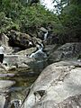
Falls above the bridge.
