
Mutarnee, Queensland facts for kids
Quick facts for kids MutarneeQueensland |
|||||||||||||||
|---|---|---|---|---|---|---|---|---|---|---|---|---|---|---|---|
.jpg)
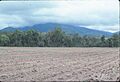
Ploughed paddock, Mutarnee, 1984
|
|||||||||||||||

Mutarnee
Location in Queensland
|
|||||||||||||||
| Population | 120 (2021 census) | ||||||||||||||
| • Density | 2.01/km2 (5.2/sq mi) | ||||||||||||||
| Postcode(s) | 4816 | ||||||||||||||
| Area | 59.7 km2 (23.1 sq mi) | ||||||||||||||
| Time zone | AEST (UTC+10:00) | ||||||||||||||
| Location |
|
||||||||||||||
| LGA(s) | City of Townsville | ||||||||||||||
| State electorate(s) | Hinchinbrook | ||||||||||||||
| Federal Division(s) | Herbert | ||||||||||||||
|
|||||||||||||||
Mutarnee is a small town near the coast in Queensland, Australia. It is part of the City of Townsville. In 2021, about 120 people lived in Mutarnee.
Contents
Exploring Mutarnee's Location
Mutarnee is about 67 kilometers (42 miles) north-west of Townsville. It is also 44 kilometers (27 miles) south-east of Ingham. The town sits by Crystal Creek, close to the rainforest village of Paluma.
How Land is Used in Mutarnee
The main part of Mutarnee has homes spread out in the countryside. Other areas are used for farming, like growing sugarcane. Some land is also used for grazing animals.
Roads and Railways
The Bruce Highway passes right through Mutarnee. It connects the town to Rollingstone in the south-east and Coolbie in the north-west.
The North Coast railway line runs next to the highway. There are two railway stations in the area:
- Mutarnee railway station (18°57′00″S 146°17′25″E / 18.9499°S 146.2903°E)
- Moongobulla railway station, which is no longer used (18°58′41″S 146°19′50″E / 18.9781°S 146.3305°E)
Mutarnee's Past
The name Mutarnee comes from its railway station. In 1920, the Queensland Railways Department named it using an Aboriginal word. The word means food, and it was suggested by Archibald Meston.
Schools in Mutarnee's History
Ollera Provisional School opened in 1905 but closed a year later. Ollera Creek State School started in 1920. In 1923, its name changed to Mutarnee State School.
Mutarnee's Population
In 2016, about 116 people lived in Mutarnee. By 2021, the population had grown slightly to 120 people.
Learning in Mutarnee
Mutarnee State School is a government primary school for students from Prep to Year 6. It is located on School Road (18°57′18″S 146°17′14″E / 18.9550°S 146.2871°E). In 2017, the school had 19 students and 3 teachers.
Mungalla Silver Lining School is a private high school for Indigenous boys and girls. It teaches students from Year 7 to Year 12 at 64 Spiegelhauer Road (18°58′07″S 146°17′17″E / 18.9685°S 146.2881°E).
There isn't a government high school in Mutarnee itself. Students usually go to Ingham State High School in Ingham or Northern Beaches State High School in Deeragun, Townsville.
What Mutarnee Offers
Mutarnee has a state primary school for local children. There is also a fun waterhole and a camping area at nearby Crystal Creek. These spots are great for outdoor activities.
Images for kids
-
Ploughed paddock, Mutarnee, 1984
