Paluma, Queensland facts for kids
Quick facts for kids PalumaQueensland |
|||||||||||||||
|---|---|---|---|---|---|---|---|---|---|---|---|---|---|---|---|

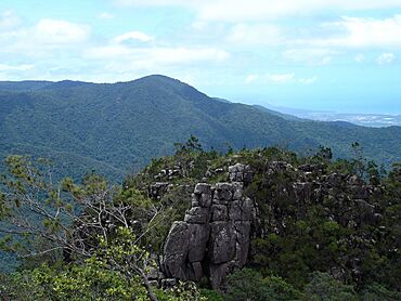
Looking towards the Coral Sea from Paluma, 2005
|
|||||||||||||||
| Population | 87 (2021 census) | ||||||||||||||
| • Density | 0.03789/km2 (0.0981/sq mi) | ||||||||||||||
| Postcode(s) | 4816 | ||||||||||||||
| Area | 2,296.2 km2 (886.6 sq mi) | ||||||||||||||
| Time zone | AEST (UTC+10:00) | ||||||||||||||
| Location |
|
||||||||||||||
| LGA(s) |
|
||||||||||||||
| State electorate(s) |
|
||||||||||||||
| Federal Division(s) | Kennedy | ||||||||||||||
|
|||||||||||||||
Paluma is a small town in Queensland, Australia. It is part of the City of Townsville and also stretches into the Charters Towers Region. In 2021, about 87 people lived here.
Paluma is located in the beautiful Mount Spec Ranges. It marks the southernmost part of Townsville's amazing Wet Tropics. This area is a special place with lots of unique plants and animals.
Contents
Exploring Paluma's Geography
Paluma is mostly a small town in the eastern part of its area. This eastern section is within the City of Townsville. Most of the houses are found here.
The larger western part of Paluma is in the Charters Towers Region. This huge area is used for different things. You'll find places where animals graze on natural plants. It also includes the Paluma Range National Park, the Paluma State Forest, and the Mount Zero Taravale Private Nature Reserve. This nature reserve is looked after by the Australian Wildlife Conservancy.
Mountains Around Paluma
Paluma is surrounded by many mountains. Here are some of the notable ones:
- Black Hill (534 meters high)
- Krugers Hill
- Mount Bitalli
- Mount Bradley (548 meters high)
- Mount Brown (449 meters high)
- Mount Foxton (464 meters high)
- Mount Julia (530 meters high)
- Mount Moss
- Mount Nokomis (697 meters high)
- Mount Podge (547 meters high)
- Mount Ryan (815 meters high)
- Mount Spectacle (472 meters high)
- Mount Zero (1041 meters high)
- Pinnacle
- Powell Knob (439 meters high)
- Snake Hill
- Sugarloaf (567 meters high)
- Trial Hill (662 meters high)
- Twin Hills (579 meters high)
- Willett Knob (427 meters high)
Paluma's Interesting History
Paluma was first known as Cloudy Clearing. It got its current name, Paluma, in 1934.
The town grew because of mining and logging. The first people to arrive were looking for tin in the mountains. This was back in the 1870s. For a long time, the area was hard to reach. Then, a road was built up the mountain range in the 1930s.
The tin mining continued for many years. However, the miners used the creeks to wash the tin. This caused problems for the town's water supply. Eventually, local landowners worked together to stop the tin mining. This helped protect the clean water for Paluma.
Schools in Paluma's Past
Several schools have opened and closed in the Paluma area over the years:
- Running River Provisional School opened in 1946. It closed and reopened a few times before closing permanently in 1994.
- Paluma Temporary School started in 1950. It became Paluma State School in 1952. This school closed in 1968 because not enough students were attending.
People Living in Paluma
The number of people living in Paluma has changed over time.
- In 2016, there were 68 people living in the area.
- By 2021, the population had grown to 87 people.
Amazing Heritage Sites
Paluma has a special heritage site called the Mount Spec Road and Little Crystal Creek Bridge. This road and bridge were built in 1933. The bridge is made of stone arches. It is the only arch road bridge still used in Queensland!
Crystal clear water flows down Little Crystal Creek. It fills deep pools, making it a wonderful natural swimming spot. This site is so important that it's listed on the Queensland Heritage Register.
Education Opportunities
The Paluma Environmental Education Centre is a unique school. It is located at 53 Mt Spec Road. This center helps students from years 1 to 12 learn about nature. One of its classrooms is even built right under the forest canopy!
There are no regular primary or secondary schools directly in Paluma. The closest primary schools are Mutarnee State School and Mount Fox State School. For high school, students usually go to Ingham State High School in Ingham. Because Paluma is a large area, some students might need to use distance education or attend boarding schools.
 | Emma Amos |
 | Edward Mitchell Bannister |
 | Larry D. Alexander |
 | Ernie Barnes |


