Dotswood, Queensland facts for kids
Quick facts for kids DotswoodQueensland |
|||||||||||||||
|---|---|---|---|---|---|---|---|---|---|---|---|---|---|---|---|

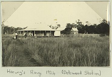
Dotswood Station homestead, 1924
|
|||||||||||||||
| Population | 83 (2021 census) | ||||||||||||||
| • Density | 0.02462/km2 (0.0638/sq mi) | ||||||||||||||
| Postcode(s) | 4820 | ||||||||||||||
| Area | 3,370.6 km2 (1,301.4 sq mi) | ||||||||||||||
| Time zone | AEST (UTC+10:00) | ||||||||||||||
| Location |
|
||||||||||||||
| LGA(s) | Charters Towers Region | ||||||||||||||
| State electorate(s) | Traeger | ||||||||||||||
| Federal Division(s) | Kennedy | ||||||||||||||
|
|||||||||||||||
Dotswood is a small rural area, also called a locality, in the Charters Towers Region of Queensland, Australia. In 2021, 83 people lived in Dotswood.
Contents
Exploring Dotswood's Landscape
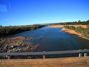
Dotswood is a large area with interesting natural features. The neighbourhood of Macrossan is found in the western part of Dotswood. It sits right next to a bridge that crosses the Burdekin River.
Railways and Roads in Dotswood
The Great Northern Railway runs through Dotswood. This railway line once had several stations here, but they are now abandoned. These old stations include:
- Macrossan railway station (20°00′18″S 146°26′44″E / 20.0051°S 146.4456°E)
- Exley railway station (19°57′05″S 146°31′21″E / 19.9515°S 146.5224°E)
- Eneby railway station (19°55′21″S 146°33′23″E / 19.9225°S 146.5563°E)
Another old station, Keelbottom railway station (19°26′34″S 146°19′00″E / 19.4427°S 146.3168°E), was on the Greenvale railway line, which is no longer in use.
The Hervey Range Developmental Road also crosses through Dotswood, running from east to west.
A Look Back at Dotswood's Past
Dotswood has a rich history, especially linked to large farming areas called pastoral runs.
Early Land Use and Stations
In 1863, Phillip Somer and Matthew Hervey were given permission to use large areas of land known as the Keelbottom and Watershed Pastoral Runs. These were big pieces of land used for grazing animals. By 1865, these men had transferred their land, which included the Emysland, Dotswood, and Keelbottom runs, to the Bank of New South Wales.
Over time, Dotswood Station grew to include many other runs. These included Arthurs Peak, Hardwick, and Yallock Vale. All these properties were important for farming and grazing in the region.
Naming Macrossan and Mining History
The neighbourhood of Macrossan gets its name from the Macrossan railway station. This station was named after a well-known politician named John Murtagh Macrossan.
In 1865, the Star River Mineral Field was discovered in this area. A mineral field is a place where valuable minerals can be found. Soon after, in 1868, the Ravenswood Gold Field was found nearby. A gold field is an area rich in gold. This gold field eventually stretched into the Star River Mineral Field.
Around 1881, people started mining for silver and lead in the Ravenswood area, especially at a place called Argentine. This period was sometimes called a "silver mania." However, this mining boom ended quickly in 1883 due to problems with processing the minerals and low profits.
The Town of Argentine
In 1872, a large area of land near Keelbottom Creek was set aside for a new town called Boolangalla. Later, in October 1882, 67 town lots were offered for sale in the town of Argentine. By the next year, Argentine had several public houses (like inns or pubs), shops, and gardens. In December 1888, the Star River Post Office changed its name to the Argentine Post Office.
Who Lives in Dotswood?
The number of people living in Dotswood has changed over the years. In 2016, there were 101 people living here. By 2021, the population of Dotswood was 83 people.
Places of Historical Importance
Dotswood has several heritage-listed sites. These are places that are protected because they are important to history.
- Flinders Highway, Macrossan: Macrossan Stores Depot Group
- Great Northern railway: Burdekin River Rail Bridge
Things to See and Do
If you visit Dotswood, you might want to check out Surgeons Lookout (19°41′11″S 146°32′19″E / 19.6864°S 146.5387°E). It's a place with great views.
Local Facilities
Macrossan Park is a free campground where you can stay. It's located right by the Burdekin River, between the railway and road bridges (20°00′12″S 146°26′20″E / 20.003417°S 146.438889°E).
Dotswood's Main Industry
A large part of Dotswood is used by the Department of Defence. This area is part of the Townsville Field Training Area, where military training exercises take place.
 | Aurelia Browder |
 | Nannie Helen Burroughs |
 | Michelle Alexander |


