Deeragun, Queensland facts for kids
Quick facts for kids DeeragunTownsville, Queensland |
|||||||||||||||
|---|---|---|---|---|---|---|---|---|---|---|---|---|---|---|---|

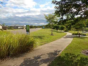
Modern housing development in Deeragun with a walkway along Saunders Creek
|
|||||||||||||||
| Population | 4,273 (2021 census) | ||||||||||||||
| • Density | 602/km2 (1,560/sq mi) | ||||||||||||||
| Postcode(s) | 4818 | ||||||||||||||
| Area | 7.1 km2 (2.7 sq mi) | ||||||||||||||
| Time zone | AEST (UTC+10:00) | ||||||||||||||
| Location | 16.5 km (10 mi) from Townsville CBD | ||||||||||||||
| LGA(s) | City of Townsville Division 1 |
||||||||||||||
| State electorate(s) | Hinchinbrook | ||||||||||||||
| Federal Division(s) | Herbert | ||||||||||||||
|
|||||||||||||||
Deeragun is a lively town and suburb located on the western side of Townsville in Queensland, Australia. It's a great place to live, with a growing community. In 2021, about 4,273 people called Deeragun home.
Contents
What's Deeragun Like?
Deeragun is about 16.5 kilometers (10 miles) west of Townsville's city center. It's mostly a place where people live, with homes and some larger properties. You'll find a small hill in the Innes Estate area and a lovely nature strip along Saunders Creek.
The main road, the Bruce Highway, runs through Deeragun from south to north-west. The suburb is bordered by the North Townsville Road and the North Coast railway line to the north. Veale Street is to the north-west, and Saunders Creek is to the south-west.
A Look Back: Deeragun's History
Deeragun is a fairly new suburb. It started to be developed in the 1990s. The area grew around an old school and the Nightjar Railway Station. Many of the first homes were built by the Housing Commission. No one is quite sure where the name "Deeragun" came from!
Here are some important dates for schools in Deeragun:
- St Anthony's Catholic School first opened its doors in 1992.
- The secondary campus of St Anthony's Catholic College welcomed students on January 24, 2005.
- Northern Beaches State High School began teaching on January 28, 1997.
Who Lives in Deeragun?
Deeragun has been growing steadily over the years.
- In 2011, about 3,525 people lived in Deeragun.
- By 2016, the population had grown to 4,250 people.
- In the most recent count in 2021, there were 4,273 residents in Deeragun.
What Can You Do in Deeragun?
Deeragun has many useful places and services for its residents.
Shopping and Services
The Woodlands Village Shopping Centre is a popular spot. It has a supermarket, a bottle shop, and a post office. You can also find several fast food places, medical and vet services, and a petrol station there. More shops and restaurants have been added since 2011.
Community Spots
You'll also find a police station in Deeragun. There's a Community Recreation Hall for events and activities. A few churches are located here too. If you love skateboarding, the Woodlands Skate Park is a great place to hang out!
The Townsville City Council offers a mobile library service. It visits the North Townsville Community Hub in Deeragun on Monday mornings, so you can borrow books and more.
Getting Around Deeragun
Deeragun is well-connected, making it easy to travel.
Main Roads
The Bruce Highway runs along the northern edge of Deeragun. This is where the Bruce Highway becomes a dual lane road when you're coming into Townsville from the north. The Townsville Ring Road is a fast bypass road. It helps traffic move smoothly between Deeragun and Bohle Plains.
Buses and Taxis
The Hermit Park Bus Service connects Deeragun to Townsville. Their "Route 33" bus goes directly to the bus exchanges in Aitkenvale and the Townsville CBD. This bus route is part of the qconnect program by the Department of Transport and Main Roads. It also stops in Bushland Beach.
If you need another way to get around, taxi services are available. Townsville Taxis operates this service in Deeragun.
Airport Access
Deeragun is quite close to Townsville Airport. It's only about 13.5 kilometers (8.4 miles) away, which is handy for travel.
Schools in Deeragun
Deeragun has excellent schools for students of all ages.
St Anthony's Catholic College
St Anthony's Catholic College is a school for both primary (Prep to Year 6) and secondary (Year 7 to Year 12) students. It's located at the corner of Veales Road and Joanne Street. In 2017, the school had 1,236 students.
Northern Beaches State High School
Northern Beaches State High School is a government school for secondary students (Year 7 to Year 12). It's for both boys and girls and is located on Meranti Street. In 2017, 760 students attended this school. It also has a special education program.
Primary Schools and Child Care
There isn't a government primary school directly in Deeragun. The closest one is Bohlevale State School, just across the Bruce Highway in Burdell.
Deeragun also has several child care facilities. These places help look after younger children.
 | Victor J. Glover |
 | Yvonne Cagle |
 | Jeanette Epps |
 | Bernard A. Harris Jr. |


