
Mount Sumbing facts for kids
Quick facts for kids Mount Sumbing |
|
|---|---|

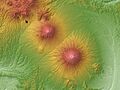
Mount Sumbing seen from Borobudur temple park
|
|
| Highest point | |
| Elevation | 3,371 m (11,060 ft) |
| Prominence | 2,577 m (8,455 ft) |
| Listing | Ultra Ribu |
| Geography | |

Mount Sumbing
Location in Java
|
|
| Parent range | Sunda Arc |
| Geology | |
| Age of rock | 701.000 Years |
| Mountain type | Stratovolcano |
| Last eruption | 1730 (?) |
| Climbing | |
| Normal route | Garung |

Mount Sumbing, also known as Gunung Sumbing, is an active stratovolcano in Central Java, Indonesia. It looks very similar to its nearby volcano, Mount Sindoro. The last time it erupted was in 1730. This was the only eruption ever recorded. At the very top, it has a small crater. This crater was formed by steam and gas explosions.
Where Rivers Begin
The top of Mount Sumbing is a special place. It acts like a giant split for water. Rainwater that falls on the mountain flows into three different river basins. These are like huge bowls that collect water.
The Three Basins
- The Progo basin is on the eastern side of the mountain.
- The Serayu basin is on the western side.
- The Bogowonto basin is also on the western side.
The Progo River Basin covers more than half of the Mount Sumbing area. All these rivers flow south towards the Indian Ocean.
Images for kids
-
Mount Sundoro (left) and Mount Sumbing (right) on a map.
-
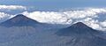
Mount Sumbing (left) and Mount Sindoro (right) seen from an airplane.
-
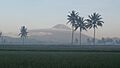
The outline of Mount Sumbing from Bondowoso, Temanggung.


See also
- List of volcanoes in Indonesia
- List of ultras of the Malay Archipelago
- Progo River
- Serayu River
