
List of volcanoes in Indonesia facts for kids


Indonesia is a country with many volcanoes. These volcanoes are formed because huge pieces of the Earth's crust, called tectonic plates, are always moving and crashing into each other. Indonesia sits on the Pacific Ring of Fire, a horseshoe-shaped area known for lots of earthquakes and volcanoes.
Some of Indonesia's volcanoes are very famous for their powerful eruptions. For example, Krakatoa erupted in 1883, causing effects all over the world. The Lake Toba Caldera had a super-huge eruption about 74,000 years ago, which even caused a "volcanic winter" for six years! Mount Tambora had the strongest eruption ever recorded in 1815.
Indonesia has about 127 active volcanoes. Around 5 million people live close to these volcanoes, in areas that could be dangerous. The word for Mount or Mountain in Indonesia is Gunung. So, Mount Merapi is often called Gunung Merapi.
Contents
Indonesia's Volcanoes: A Closer Look
Indonesia's many volcanoes are grouped into six main areas. Four of these groups are part of the Sunda Arc, which is a long chain of volcanoes. The other two groups are found in Halmahera and the islands around it, and in Sulawesi and the Sangihe Islands.
The most active volcano in Indonesia is Mount Merapi on the island of Java. Since the year 1000 AD, another volcano called Kelut has erupted more than 30 times. Mount Merapi has erupted over 80 times! Because it's so active, Mount Merapi was named a "Decade Volcano" in 1995. This means scientists are watching it very closely.
Volcanoes of Sumatra

The island of Sumatra has a long mountain range called Bukit Barisan. This mountain range stretches for about 1,700 kilometers (1,050 miles) from north to south. It was formed by the movement of the Australian tectonic plate. This plate moves about 5.5 centimeters (2.2 inches) each year, causing big earthquakes on Sumatra's western side. This movement also creates the magma chambers that feed the volcanoes.
Sumatra has 35 active volcanoes. Only one, Weh, is separated from the main island. It became an island after a huge eruption in the past filled the lowlands with sea water. The largest volcano in Sumatra is the supervolcano Toba. It sits inside a giant crater, or caldera, that is 100 km (60 mi) long and 30 km (20 mi) wide. This caldera was formed after a massive eruption about 74,000 years ago. That eruption was a level 8 on the Volcanic Explosivity Index (VEI), which is the highest level! The tallest volcano in Sumatra is Mount Kerinci, standing at 3,800 meters (12,467 feet).
| Name | Shape | Elevation | Last eruption (VEI) | Coordinates |
|---|---|---|---|---|
| Weh | stratovolcano | 617 metres (2,024 ft) | Pleistocene | 5°49′N 95°17′E / 5.82°N 95.28°E |
| Seulawah Agam | stratovolcano | 1,810 metres (5,940 ft) | 1839 (2) | 5°26′53″N 95°39′29″E / 5.448°N 95.658°E |
| Peuet Sague | complex volcano | 2,801 metres (9,190 ft) | 25 December 2000 (2) | 4°54′50″N 96°19′44″E / 4.914°N 96.329°E |
| Geureudong | stratovolcano | 2,885 metres (9,465 ft) | 1937 | 4°48′47″N 96°49′12″E / 4.813°N 96.82°E |
| Kembar | shield volcano | 2,245 metres (7,365 ft) | Pleistocene | 3°51′00″N 97°39′50″E / 3.850°N 97.664°E |
| Sibayak | stratovolcano | 2,212 metres (7,257 ft) | 1881 | 3°14′N 98°31′E / 3.23°N 98.52°E |
| Sinabung | stratovolcano | 2,460 metres (8,070 ft) | 2 March 2021 | 3°10′12″N 98°23′31″E / 3.17°N 98.392°E |
| Toba | supervolcano | 2,157 metres (7,077 ft) | 75000 BC (8) | 2°35′N 98°50′E / 2.58°N 98.83°E |
| Helatoba-Tarutung | fumarole field | 1,100 metres (3,600 ft) | Pleistocene | 2°02′N 98°56′E / 2.03°N 98.93°E |
| Imun | unknown | 1,505 metres (4,938 ft) | unknown | 2°09′29″N 98°55′48″E / 2.158°N 98.93°E |
| Sibualbuali | stratovolcano | 1,819 metres (5,968 ft) | unknown | 1°33′22″N 99°15′18″E / 1.556°N 99.255°E |
| Lubukraya | stratovolcano | 1,862 metres (6,109 ft) | unknown | 1°28′41″N 99°12′32″E / 1.478°N 99.209°E |
| Sorikmarapi | stratovolcano | 2,145 metres (7,037 ft) | 1986 (1) | 0°41′10″N 99°32′20″E / 0.686°N 99.539°E |
| Talakmau | complex volcano | 2,919 metres (9,577 ft) | unknown | 0°04′44″N 99°58′48″E / 0.079°N 99.98°E |
| Sarik-Gajah | volcanic cone | unknown | unknown | 0°00′29″N 100°12′00″E / 0.008°N 100.20°E |
| Marapi | complex volcano | 2,885 metres (9,465 ft) | 2024 | 0°22′52″S 100°28′23″E / 0.381°S 100.473°E |
| Tandikat | stratovolcano | 2,438 metres (7,999 ft) | 1924 (1) | 0°25′59″S 100°19′01″E / 0.433°S 100.317°E |
| Talang | stratovolcano | 2,597 metres (8,520 ft) | 27 November 2007 (2) | 0°58′41″S 100°40′44″E / 0.978°S 100.679°E |
| Kerinci | stratovolcano | 3,800 metres (12,500 ft) | 2019 (on going) | 1°41′49″S 101°15′50″E / 1.697°S 101.264°E |
| Hutapanjang | stratovolcano | 2,021 metres (6,631 ft) | unknown | 2°20′S 101°36′E / 2.33°S 101.60°E |
| Sumbing | stratovolcano | 2,507 metres (8,225 ft) | 23 May 1921 (2) | 2°24′50″S 101°43′41″E / 2.414°S 101.728°E |
| Masurai | stratovolcano | 2,916 metres (9,567 ft) | Pleistocene | 2°30′11″S 101°43′41″E / 2.503°S 101.728°E |
| Kunyit | stratovolcano | 2,151 metres (7,057 ft) | unknown | 2°35′31″S 101°51′00″E / 2.592°S 101.85°E |
| Pendan | unknown | unknown | unknown | 2°49′S 102°01′E / 2.82°S 102.02°E |
| Belirang-Beriti | complex volcano | 1,958 metres (6,424 ft) | unknown | 2°49′S 102°11′E / 2.82°S 102.18°E |
| Bukit Daun | stratovolcano | 2,467 metres (8,094 ft) | unknown | 3°23′S 102°22′E / 3.38°S 102.37°E |
| Kaba | stratovolcano | 1,952 metres (6,404 ft) | 22 August 2000 (1) | 3°31′S 102°37′E / 3.52°S 102.62°E |
| Dempo | stratovolcano | 3,173 metres (10,410 ft) | 2018 (1) | 4°02′S 103°08′E / 4.03°S 103.13°E |
| Patah | unknown | 2,817 metres (9,242 ft) | unknown | 4°16′S 103°18′E / 4.27°S 103.30°E |
| Bukit Lumut Balai | stratovolcano | 2,055 metres (6,742 ft) | unknown | 4°14′S 103°37′E / 4.23°S 103.62°E |
| Besar | stratovolcano | 1,899 metres (6,230 ft) | April 1940 (1) | 4°26′S 103°40′E / 4.43°S 103.67°E |
| Ranau | caldera | 1,881 metres (6,171 ft) | unknown | 4°50′S 103°55′E / 4.83°S 103.92°E |
| Sekincau Belirang | caldera | 1,719 metres (5,640 ft) | unknown | 5°07′S 104°19′E / 5.12°S 104.32°E |
| Suoh | caldera | 1,000 metres (3,300 ft) | 10 July 1933 (4) | 5°15′S 104°16′E / 5.25°S 104.27°E |
| Hulubelu | caldera | 1,040 metres (3,410 ft) | 1836 | 5°21′S 104°36′E / 5.35°S 104.60°E |
| Rajabasa | stratovolcano | 1,281 metres (4,203 ft) | 1798 | 5°46′48″S 105°37′30″E / 5.78°S 105.625°E |
Volcanoes of Sunda Strait and Java
The Sunda Strait is a body of water that separates the islands of Sumatra and Java. The famous volcanic island Krakatoa sits right in the middle of this strait. Krakatoa had a super violent eruption in 1883. It destroyed two-thirds of the island and left a huge underwater crater. The sound of this explosion was heard thousands of miles away! A new volcano, called Anak Krakatau (meaning "Child of Krakatau"), started growing from the sea in 1930.
Java is a smaller island than Sumatra, but it has even more active volcanoes. There are 45 active volcanoes on Java, plus many smaller craters and cones. Mount Merapi, Semeru, and Kelud are the most active ones. Mount Semeru has been erupting almost non-stop since 1967. Another volcano, Ijen, has a unique, colorful lake in its crater. This lake is extremely acidic, like strong battery acid! People even mine sulfur by hand from around this lake.
| Name | Shape | Elevation | Last eruption (VEI) | Coordinates |
|---|---|---|---|---|
| Krakatau | caldera | 813 metres (2,667 ft) | 2022 (ongoing) | 6°06′07″S 105°25′23″E / 6.102°S 105.423°E |
| Pulosari | stratovolcano | 1,346 metres (4,416 ft) | unknown | 6°20′31″S 105°58′30″E / 6.342°S 105.975°E |
| Gunung Karang | stratovolcano | 1,778 metres (5,833 ft) | unknown | 6°16′12″S 106°02′31″E / 6.27°S 106.042°E |
| Salak | stratovolcano | 2,211 metres (7,254 ft) | 31 January 1938 (2) | 6°43′S 106°44′E / 6.72°S 106.73°E |
| Kiaraberes-Gagak | stratovolcano | 1,511 metres (4,957 ft) | 6 April 1939 (1) | 6°44′S 106°39′E / 6.73°S 106.65°E |
| Perbakti | stratovolcano | 1,699 metres (5,574 ft) | unknown | 6°45′S 106°41′E / 6.75°S 106.68°E |
| Kendeng | stratovolcano | 1,732 metres (5,682 ft) | Pleistocene | 6°46′05″S 106°31′34″E / 6.768°S 106.526°E |
| Gede | stratovolcano | 2,958 metres (9,705 ft) | 13 March 1957 (2) | 6°47′S 106°59′E / 6.78°S 106.98°E |
| Patuha | stratovolcano | 2,434 metres (7,986 ft) | unknown | 7°09′36″S 107°24′00″E / 7.160°S 107.40°E |
| Wayang-Windu | lava dome | 2,182 metres (7,159 ft) | unknown | 7°12′29″S 107°37′48″E / 7.208°S 107.63°E |
| Malabar | stratovolcano | 2,343 metres (7,687 ft) | unknown | 7°08′S 107°39′E / 7.13°S 107.65°E |
| Tangkuban Perahu | stratovolcano | 2,084 metres (6,837 ft) | 26 June 2019 (1) | 6°46′S 107°36′E / 6.77°S 107.60°E |
| Papandayan | stratovolcano | 2,665 metres (8,743 ft) | 11 November 2002 (2) | 7°19′S 107°44′E / 7.32°S 107.73°E |
| Kendang | stratovolcano | 2,608 metres (8,556 ft) | unknown | 7°14′S 107°43′E / 7.23°S 107.72°E |
| Kamojang | stratovolcano | 1,730 metres (5,680 ft) | Pleistocene | 7°07′30″S 107°48′00″E / 7.125°S 107.80°E |
| Guntur | complex volcano | 2,249 metres (7,379 ft) | 16 October 1847 (2) | 7°08′35″S 107°50′24″E / 7.143°S 107.840°E |
| Tampomas | stratovolcano | 1,684 metres (5,525 ft) | unknown | 6°46′S 107°57′E / 6.77°S 107.95°E |
| Galunggung | stratovolcano | 2,168 metres (7,113 ft) | 9 January 1984 (1) | 7°15′00″S 108°03′29″E / 7.25°S 108.058°E |
| Talagabodas | stratovolcano | 2,201 metres (7,221 ft) | unknown | 7°12′29″S 108°04′12″E / 7.208°S 108.07°E |
| Karaha | fumarole | 1,155 metres (3,789 ft) | unknown | 7°07′S 108°05′E / 7.12°S 108.08°E |
| Cereme | stratovolcano | 3,078 metres (10,098 ft) | 1951 | 6°53′31″S 108°24′00″E / 6.892°S 108.40°E |
| Slamet | stratovolcano | 3,432 metres (11,260 ft) | 2014 | 7°14′31″S 109°12′29″E / 7.242°S 109.208°E |
| Dieng | complex volcano | 2,565 metres (8,415 ft) | 29 April 2021 (?) | 7°12′S 109°55′E / 7.20°S 109.92°E |
| Sundoro | stratovolcano | 3,136 metres (10,289 ft) | 29 October 1971 (2) | 7°18′00″S 109°59′31″E / 7.30°S 109.992°E |
| Sumbing | stratovolcano | 3,371 metres (11,060 ft) | 1730 (?) | 7°23′02″S 110°04′12″E / 7.384°S 110.070°E |
| Ungaran | stratovolcano | 2,050 metres (6,730 ft) | unknown | 7°11′S 110°20′E / 7.18°S 110.33°E |
| Telomoyo | stratovolcano | 1,894 metres (6,214 ft) | unknown | 7°22′S 110°24′E / 7.37°S 110.40°E |
| Merbabu | stratovolcano | 3,145 metres (10,318 ft) | 1797 (2) | 7°27′S 110°26′E / 7.45°S 110.43°E |
| Merapi | stratovolcano | 2,968 metres (9,738 ft) | 2019 (ongoing) | 7°32′31″S 110°26′31″E / 7.542°S 110.442°E |
| Muria | stratovolcano | 1,625 metres (5,331 ft) | 160 BC ± 30 years | 6°37′S 110°53′E / 6.62°S 110.88°E |
| Lawu | stratovolcano | 3,265 metres (10,712 ft) | 28 November 1885 (1) | 7°37′30″S 111°11′31″E / 7.625°S 111.192°E |
| Wilis | stratovolcano | 2,563 metres (8,409 ft) | unknown | 7°48′29″S 111°45′29″E / 7.808°S 111.758°E |
| Kelud | stratovolcano | 1,731 metres (5,679 ft) | 13 February 2014 (4) | 7°55′48″S 112°18′29″E / 7.93°S 112.308°E |
| Kawi–Butak | stratovolcano | 2,651 metres (8,698 ft) | unknown | 7°55′S 112°27′E / 7.92°S 112.45°E |
| Arjuno–Welirang | stratovolcano | 3,339 metres (10,955 ft) | 15 August 1952 (0) | 7°43′30″S 112°34′48″E / 7.725°S 112.58°E |
| Penanggungan | stratovolcano | 1,653 metres (5,423 ft) | unknown | 7°37′S 112°38′E / 7.62°S 112.63°E |
| Malang Plain | maar | 680 metres (2,230 ft) | unknown | 8°01′S 112°41′E / 8.02°S 112.68°E |
| Semeru | stratovolcano | 3,676 metres (12,060 ft) | 2021 (ongoing) | 8°06′29″S 112°55′12″E / 8.108°S 112.92°E |
| Bromo | stratovolcano | 2,329 metres (7,641 ft) | 2021 | 7°56′31″S 112°57′00″E / 7.942°S 112.95°E |
| Lamongan | stratovolcano | 1,651 metres (5,417 ft) | 5 February 1898 (2) | 7°58′44″S 113°20′31″E / 7.979°S 113.342°E |
| Lurus | complex volcano | 539 metres (1,768 ft) | unknown | 7°44′S 113°35′E / 7.73°S 113.58°E |
| Iyang-Argapura | complex volcano | 3,088 metres (10,131 ft) | unknown | 7°58′S 113°34′E / 7.97°S 113.57°E |
| Raung | stratovolcano | 3,332 metres (10,932 ft) | 2021 (?) | 8°07′30″S 114°02′31″E / 8.125°S 114.042°E |
| Ijen | stratovolcano | 2,799 metres (9,183 ft) | 28 June 1999 (1) | 8°03′29″S 114°14′31″E / 8.058°S 114.242°E |
| Baluran | stratovolcano | 1,247 metres (4,091 ft) | unknown | 7°51′S 114°22′E / 7.85°S 114.37°E |
Note: The height of Krakatau listed is for Rakata, which is one of the islands left after the 1883 eruption, not the active Anak Krakatau.
Volcanoes of the Lesser Sunda Islands
The Lesser Sunda Islands are a group of smaller islands to the east of Java. They include Bali, Lombok, Sumbawa, Flores, Sumba, and the Timor islands. These islands are located on the edge of the Australian continental shelf. The volcanoes here are formed by the movement of the Earth's oceanic crust. Some volcanoes are so big they make up an entire island, like Sangeang Api. Mount Tambora, on Sumbawa island, erupted in 1815. This eruption was a VEI 7, making it the most powerful eruption in recorded history!
| Name | Island | Shape | Elevation | Last eruption (VEI) | Coordinates |
|---|---|---|---|---|---|
| Merbuk | Bali | unknown | 1,386 metres (4,547 ft) | unknown | 8°13′S 114°39′E / 8.22°S 114.65°E |
| Bratan | Bali | caldera | 2,276 metres (7,467 ft) | unknown | 8°17′S 115°08′E / 8.28°S 115.13°E |
| Batur | Bali | caldera | 1,717 metres (5,633 ft) | 2000 (1) | 8°14′31″S 115°22′30″E / 8.242°S 115.375°E |
| Agung | Bali | stratovolcano | 3,031 metres (9,944 ft) | 2019 | 8°20′31″S 115°30′29″E / 8.342°S 115.508°E |
| Samalas | Lombok | stratovolcano | 2,867 metres (9,406 ft) | 1257 (7) | 8°25′S 116°24′E / 8.41°S 116.40°E |
| Rinjani | Lombok | stratovolcano | 3,726 metres (12,224 ft) | 2016 (2) | 8°25′S 116°28′E / 8.42°S 116.47°E |
| Tambora | Sumbawa | stratovolcano | 2,722 metres (8,930 ft) | 1967 ± 20 years (0) | 8°15′S 118°00′E / 8.25°S 118.00°E |
| Sangeang Api | Sangeang | complex volcano | 1,949 metres (6,394 ft) | 2019 (ongoing) | 8°12′S 119°04′E / 8.20°S 119.07°E |
| Wai Sano | Flores | caldera | 903 metres (2,963 ft) | unknown | 8°43′S 120°01′E / 8.72°S 120.02°E |
| Poco Leok | Flores | unknown | 1,675 metres (5,495 ft) | unknown | 8°41′S 120°29′E / 8.68°S 120.48°E |
| Ranakah | Flores | lava dome | 2,100 metres (6,900 ft) | March 1991 (1) | 8°37′S 120°31′E / 8.62°S 120.52°E |
| Inierie | Flores | stratovolcano | 2,245 metres (7,365 ft) | 8050 BC | 8°52′30″S 120°57′00″E / 8.875°S 120.95°E |
| Inielika | Flores | complex volcano | 1,559 metres (5,115 ft) | 11 January 2001 (2) | 8°44′S 120°59′E / 8.73°S 120.98°E |
| Ebulobo | Flores | stratovolcano | 2,124 metres (6,969 ft) | 27 February 1969 (2) | 8°49′S 121°11′E / 8.82°S 121.18°E |
| Iya | Flores | stratovolcano | 637 metres (2,090 ft) | 27 January 1969 (3) | 8°53′49″S 121°38′42″E / 8.897°S 121.645°E |
| Sukaria | Flores | caldera | 1,500 metres (4,900 ft) | unknown | 8°47′31″S 121°46′12″E / 8.792°S 121.77°E |
| Ndete Napu | Flores | fumarole | 750 metres (2,460 ft) | unknown | 8°43′S 121°47′E / 8.72°S 121.78°E |
| Kelimutu | Flores | complex volcano | 1,639 metres (5,377 ft) | 3 June 1968 (1) | 8°46′S 121°49′E / 8.77°S 121.82°E |
| Paluweh | Palu'e | stratovolcano | 875 metres (2,871 ft) | 3 February 1985 (1) | 8°19′12″S 121°42′29″E / 8.32°S 121.708°E |
| Egon | Flores | stratovolcano | 1,703 metres (5,587 ft) | 2008 | 8°40′S 122°27′E / 8.67°S 122.45°E |
| Ilimuda | Flores | stratovolcano | 1,100 metres (3,600 ft) | unknown | 8°28′41″S 122°40′16″E / 8.478°S 122.671°E |
| Lewotobi | Flores | stratovolcano | 1,703 metres (5,587 ft) | 2024 | 8°32′31″S 122°46′30″E / 8.542°S 122.775°E |
| Leroboleng | Flores | complex volcano | 1,117 metres (3,665 ft) | 26 June 2003 (3) | 8°21′29″S 122°50′31″E / 8.358°S 122.842°E |
| Riang Kotang | Flores | fumarole | 200 metres (660 ft) | unknown | 8°18′00″S 122°53′31″E / 8.30°S 122.892°E |
| Iliboleng | Adonara Island | stratovolcano | 1,659 metres (5,443 ft) | June 1993 (1) | 8°20′31″S 123°15′29″E / 8.342°S 123.258°E |
| Lewotolo | Lembata | stratovolcano | 1,423 metres (4,669 ft) | 2020 (ongoing) | 8°16′19″S 123°30′18″E / 8.272°S 123.505°E |
| Ililabalekan | Lembata | stratovolcano | 1,018 metres (3,340 ft) | unknown | 8°33′S 123°23′E / 8.55°S 123.38°E |
| Iliwerung | Lembata | complex volcano | 1,018 metres (3,340 ft) | 29 November 2021 | 8°32′S 123°34′E / 8.53°S 123.57°E |
| Batu Tara | Komba island | stratovolcano | 748 metres (2,454 ft) | 2007–2015 (2) | 7°47′31″S 123°34′44″E / 7.792°S 123.579°E |
| Sirung | Pantar Island | complex volcano | 862 metres (2,828 ft) | 2021 | 8°30′29″S 124°07′48″E / 8.508°S 124.13°E |
| Yersey | – | submarine | −3,800 metres (−12,500 ft) | unknown | 7°32′S 123°57′E / 7.53°S 123.95°E |
Volcanoes of the Banda Sea
The Banda Sea is located south of the Molucca archipelago. Underneath this sea, three major tectonic plates have been pushing against each other for millions of years. The volcanoes in the Banda Sea are mostly islands, but some are submarine volcanoes, meaning they are completely underwater.
| Name | Shape | Elevation | Last eruption (VEI) | Coordinates |
|---|---|---|---|---|
| Emperor of China | submarine | −2,850 metres (−9,350 ft) | unknown | 6°37′S 124°13′E / 6.62°S 124.22°E |
| Nieuwerkerk | submarine | −2,285 metres (−7,497 ft) | unknown | 6°36′00″S 124°40′30″E / 6.60°S 124.675°E |
| Gunungapi Wetar | stratovolcano | 282 metres (925 ft) | 1699 (3) | 6°38′31″S 126°39′00″E / 6.642°S 126.65°E |
| Wurlali | stratovolcano | 868 metres (2,848 ft) | 3 June 1892 (2) | 7°07′30″S 128°40′30″E / 7.125°S 128.675°E |
| Teon | stratovolcano | 655 metres (2,149 ft) | 3 June 1904 (2) | 6°55′12″S 129°07′30″E / 6.92°S 129.125°E |
| Nila | stratovolcano | 781 metres (2,562 ft) | 7 May 1968 (1) | 6°44′S 129°30′E / 6.73°S 129.50°E |
| Serua | stratovolcano | 641 metres (2,103 ft) | 18 September 1921 (2) | 6°18′S 130°00′E / 6.30°S 130.00°E |
| Manuk | stratovolcano | 282 metres (925 ft) | unknown | 5°31′48″S 130°17′31″E / 5.53°S 130.292°E |
| Banda Api | caldera | 640 metres (2,100 ft) | 9 May 1988 (3) | 4°31′30″S 129°52′16″E / 4.525°S 129.871°E |
Volcanoes of Sulawesi and Sangihe Islands
The island of Sulawesi has a unique shape with four long peninsulas. While the central part is mountainous, most of the active volcanoes are found in the northern peninsula. This chain of volcanoes continues north to the Sangihe Islands, which are close to the Philippines.
| Name | Shape | Elevation | Last eruption (VEI) | Coordinates |
|---|---|---|---|---|
| Colo | stratovolcano | 507 metres (1,663 ft) | 18 July 1983 (4) | 0°10′12″S 121°36′29″E / 0.17°S 121.608°E |
| Ambang | complex volcano | 1,795 metres (5,889 ft) | 1845 ± 5 years | 0°45′N 124°25′E / 0.75°N 124.42°E |
| Soputan | stratovolcano | 1,784 metres (5,853 ft) | December 2018 | 1°06′29″N 124°43′48″E / 1.108°N 124.73°E |
| Sempu | caldera | 1,549 metres (5,082 ft) | unknown | 1°07′48″N 124°45′29″E / 1.13°N 124.758°E |
| Tondano | caldera | 1,202 metres (3,944 ft) | unknown | 1°14′N 124°50′E / 1.23°N 124.83°E |
| Lokon–Empung | stratovolcano | 1,580 metres (5,180 ft) | 2015 | 1°21′29″N 124°47′31″E / 1.358°N 124.792°E |
| Mahawu | stratovolcano | 1,324 metres (4,344 ft) | 16 November 1977 (0) | 1°21′29″N 124°51′29″E / 1.358°N 124.858°E |
| Klabat | stratovolcano | 1,995 metres (6,545 ft) | unknown | 1°28′N 125°02′E / 1.47°N 125.03°E |
| Tongkoko | stratovolcano | 1,149 metres (3,770 ft) | 1880 (1) | 1°31′N 125°12′E / 1.52°N 125.20°E |
| Ruang | stratovolcano | 725 metres (2,379 ft) | April 2024 (ongoing) | 2°18′N 125°22′E / 2.30°N 125.37°E |
| Karangetang | stratovolcano | 1,784 metres (5,853 ft) | 2019 (ongoing) | 2°47′N 125°24′E / 2.78°N 125.40°E |
| Banua Wuhu | submarine | −5 metres (−16 ft) | 18 July 1919 (3) | 3°08′17″N 125°29′28″E / 3.138°N 125.491°E |
| Awu | stratovolcano | 1,320 metres (4,330 ft) | 2 June 2004 (2) | 3°40′N 125°30′E / 3.67°N 125.50°E |
| Submarine 1922 | submarine | −5,000 metres (−16,000 ft) | unknown | 3°58′N 125°10′E / 3.97°N 125.17°E |
Volcanoes of Halmahera
Halmahera island is located in the northern part of the Molucca archipelago. This island was formed by the movement of three tectonic plates, creating four rocky peninsulas. A chain of volcanoes stretches from north to south on the western side of Halmahera. Some of these volcanoes are islands themselves, like Gamalama and Tidore. Gamalama is on the island of Ternate, which was a very important center for the spice trade hundreds of years ago. Because of this, we have old records of volcanic eruptions in Halmahera going back to the early 1500s!
| Name | Shape | Elevation | Last eruption (VEI) | Coordinates |
|---|---|---|---|---|
| Tarakan | pyroclastic cone | 318 metres (1,043 ft) | unknown | 1°50′N 127°50′E / 1.83°N 127.83°E |
| Dukono | complex volcano | 1,335 metres (4,380 ft) | 1933–2021 (ongoing) | 1°41′N 127°53′E / 1.68°N 127.88°E |
| Tobaru | unknown | 1,035 metres (3,396 ft) | unknown | 1°38′N 127°40′E / 1.63°N 127.67°E |
| Ibu | stratovolcano | 1,325 metres (4,347 ft) | 2024 | 1°29′17″N 127°37′48″E / 1.488°N 127.63°E |
| Gamkonora | stratovolcano | 1,635 metres (5,364 ft) | 9 July 2007 (?) | 1°23′N 127°32′E / 1.38°N 127.53°E |
| Todoko-Ranu | caldera | 979 metres (3,212 ft) | unknown | 1°15′N 127°28′E / 1.25°N 127.47°E |
| Jailolo | stratovolcano | 1,130 metres (3,710 ft) | unknown | 1°05′N 127°25′E / 1.08°N 127.42°E |
| Hiri | stratovolcano | 630 metres (2,070 ft) | unknown | 0°54′N 127°19′E / 0.90°N 127.32°E |
| Gamalama | stratovolcano | 1,715 metres (5,627 ft) | 2018 | 0°48′N 127°20′E / 0.80°N 127.33°E |
| Tidore | stratovolcano | 1,730 metres (5,680 ft) | unknown | 0°39′29″N 127°24′00″E / 0.658°N 127.40°E |
| Mare | stratovolcano | 308 metres (1,010 ft) | unknown | 0°34′N 127°24′E / 0.57°N 127.40°E |
| Moti | stratovolcano | 950 metres (3,120 ft) | unknown | 0°27′N 127°24′E / 0.45°N 127.40°E |
| Makian | stratovolcano | 1,357 metres (4,452 ft) | 29 July 1988 (3) | 0°19′N 127°24′E / 0.32°N 127.40°E |
| Tigalalu | stratovolcano | 422 metres (1,385 ft) | unknown | 0°04′N 127°25′E / 0.07°N 127.42°E |
| Amasing | stratovolcano | 1,030 metres (3,380 ft) | unknown | 0°32′S 127°29′E / 0.53°S 127.48°E |
| Bibinoi | stratovolcano | 900 metres (3,000 ft) | unknown | 0°46′S 127°43′E / 0.77°S 127.72°E |
Major Eruptions in Indonesia
Here is a list of some of the biggest volcanic eruptions in Indonesia. These are chosen because they were very powerful (VEI 3 or higher) or caused many deaths. The VEI (Volcanic Explosivity Index) is a scale that measures how explosive an eruption is, from 0 (not explosive) to 8 (extremely explosive).
| Eruption date | Volcano | End date | VEI | What happened | Tsunami | Ash/Rock volume | Deaths |
|---|---|---|---|---|---|---|---|
| 3 December 2023 | Marapi | 8 December 2023 | 3 | central vent eruption, pyroclastic flows, ashfall, lahar mudflows, caldera collapse | no | N/A | 24 |
| 4 December 2021 | Semeru | 5 December 2021 | 4 | central vent eruption, pyroclastic flows, ashfall, lahar mudflows, caldera collapse | no | N/A | 69 |
| 21 December 2018 | Anak Krakatoa | 10 January 2019 | 3 | central vent eruption, submarine eruption, pyroclastic flows, ashfall, lahar mudflows, caldera collapse | 1–2 m | N/A | 437 |
| 13 February 2014 | Kelut | 15 February 2014 | 4 | central vent eruption, crater lake eruption, pyroclastic flows, phreatic eruption, lava dome extrusion, lahar mudflows | no | 0.16 km3 | 4 |
| 3 November 2010 | Merapi | 8 November 2010 | 4 | central vent eruption, pyroclastic flows, lava dome extrusion, lahar mudflows | no | N/A | 353 |
| 10 February 1990 | Kelut | March 1990 | 4 | central vent eruption, crater lake eruption, pyroclastic flows, phreatic eruption, lava dome extrusion, lahar mudflows | no | 0.13 km3 | 35 |
| 18 July 1983 | Colo | December 1983 | 4 | central vent eruption, pyroclastic flows, phreatic eruption | no | N/A | 0 |
| 5 April 1982 | Galunggung | 8 January 1983 | 4 | central vent eruption, pyroclastic flows, lava flows, lahar mudflows | no | 0.37 km3 + | 68 |
| 26 April 1966 | Kelut | 27 April 1966 | 4 | central vent eruption, crater lake eruption, pyroclastic flows, lahar mudflows | no | 0.089 km3 | 212 |
| 17 March 1963 | Agung | 27 January 1964 | 5 | central vent eruption, pyroclastic flows, lava flows, lahar mudflows | no | 1 km3 | 1,148 |
| 31 August 1951 | Kelut | 31 August 1951 | 4 | central vent eruption, crater lake eruption, pyroclastic flows, lahar mudflows | no | 0.2 km3 | 7 |
| 25 November 1930 | Merapi | September 1931 | 3 | central vent eruption, radial fissure eruption, pyroclastic flows, lava flows, lava dome extrusion, lahar mudflows | no | 0.0017 km3 | 1,369 |
| 19 May 1919 | Kelut | 20 May 1919 | 4 | central vent eruption, crater lake eruption, pyroclastic flows, lahar mudflows | no | 0.19 km3 | 5,110 |
| 7 June 1892 | Awu | 12 June 1892 | 3 | central vent eruption, pyroclastic flows, lahar mudflows | yes | N/A | 1,532 |
| 26 August 1883 | Krakatoa | February 1884 | 6 | central vent eruption, submarine eruption, pyroclastic flows, ashfall, lahar mudflows, caldera collapse | 15–42 m | 5–8.5 km3 | 36,600 |
| 15 April 1872 | Merapi | 21 April 1872 | 4 | central vent eruption, pyroclastic flows | no | 0.33 km3 | 200 |
| 2 March 1856 | Awu | 17 March 1856 | 3 | central vent eruption, pyroclastic flows, lahar mudflows | yes | 0.51±0.50 km3 | 2,806 |
| 8 October 1822 | Galunggung | December 1822 | 5 | central vent eruption, pyroclastic flows, lava dome extrusion, lahar mudflows | no | 1 km3 + | 4,011 |
| 10 April 1815 | Mount Tambora | 15 July 1815 | 7 | central vent eruption, pyroclastic flows, caldera collapse | 1–2 m | 160 km3 | 71,000+ |
| 6 August 1812 | Awu | 8 August 1812 | 4 | central vent eruption, pyroclastic flows, lahar mudflows | no | 0.55±0.50 km3 | 963 |
| 12 August 1772 | Papandayan | 12 August 1772 | 3 | central vent eruption, phreatic eruption | no | N/A | 2,957 |
| 4 August 1672 | Merapi | unknown | 3 | central vent eruption, pyroclastic flows, lahar mudflows | no | N/A | 3,000 |
| 1586 | Kelut | unknown | 5 | crater lake eruption, crater lake eruption, lahar mudflows | no | 1 km3 + | 10,000 |
| September 1257 | Samalas | unknown | 7 | ||||
| ≈ 74,000 BP | Toba | unknown | 8 | pyroclastic flows, lava flows, caldera collapse | likely | 2,800 km3 | Possible near extinction of all the human population |
Images for kids
-
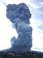
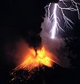
Explosive eruption of Sinabung on 9 June 2019.
-
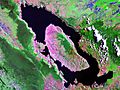
Landsat image of Lake Toba
-
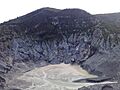
Tangkuban Perahu, taken from above
-
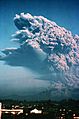
A plinian eruption of Galunggung in 1982
-
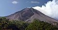
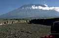
Mount Merapi, one of the most famous volcanoes in Indonesia
-
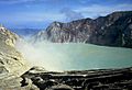
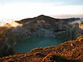
The turquoise coloured sulfuric acid lake on Ijen caldera
-
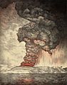
The 1883 eruption of Krakatoa produced the loudest sound.
-
Mount Agung on Bali
-
Eruption of Rinjani in 1984
-
One of three different coloured lakes of Kelimutu
-
Vuurberg (Dutch: fire mountain, Gunung Api) in Bandanaira
-
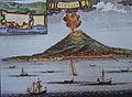
Depiction of Gamalama erupting in the early 1700s with a Portuguese fort shown


See also
- List of earthquakes in Indonesia
- Lists of volcanoes
- List of disasters in Indonesia
- Volcanism of Indonesia
- Volcanism of Java
- List of Ultras of the Malay Archipelago
