
Sumba facts for kids
|
Native name:
Humba / Hubba (in Sumba)
|
|
|---|---|
 |
|
| Geography | |
| Location | Indonesia |
| Coordinates | 9°40′S 120°00′E / 9.667°S 120.000°E |
| Archipelago | Lesser Sunda Islands |
| Area | 11,243.78 km2 (4,341.25 sq mi) |
| Area rank | 73rd |
| Highest elevation | 1,225 m (4,019 ft) |
| Highest point | Mount Wanggameti |
| Administration | |
|
Indonesia
|
|
| Province | East Nusa Tenggara |
| Largest settlement | Waingapu (pop. 71,752 - comprising Kota Waingapu and Kambera Districts) |
| Demographics | |
| Demonym | Sumbans; Sumbanese |
| Population | 820,506 (mid 2023 estimate) |
| Pop. density | 72.97 /km2 (188.99 /sq mi) |
| Languages | Predominantly native Sumba languages (Kambera, Momboru, Anakalang, Wanukaka, Wejewa, Lamboya, Kodi, Loli) and Indonesian (national language of Indonesia) |
| Ethnic groups | Predominantly Sumbans |
Sumba (also called Humba or Hubba by locals) is a beautiful island in Indonesia. It's part of the Lesser Sunda Islands group, located in Eastern Indonesia. Sumba is about the same size as Jamaica or Hawaii (Island), covering an area of 11,243.78 square kilometers.
As of mid-2023, about 820,506 people live on Sumba. The island is surrounded by other islands: Sumbawa to the northwest, Flores to the northeast, and Timor to the east. To the south, across part of the Indian Ocean, is Australia. Sumba is known for its unique culture, ancient traditions, and amazing wildlife.
Contents
What's in a Name?

The name "Sumba" comes from the local Sumba languages word humba or hubba. This word means "original" or "native." It was used by the island's first people, called tau Humba, to show they were the original inhabitants. This helped them stand out from foreigners who came to the island.
The Sumbanese people also call their land tana wai humba, which means "our native land." This phrase appears in old Sumba stories, like the tale of Inya Nyale, a mythical mermaid-like creature.
Around the 12th century, the letter 'h' in "Humba" changed to 's'. This happened when many Javanese people came from Java. In their language, humbah means "to wash," so they changed the name to avoid confusion.
Sumba's Past
Old Stories and Legends
_from_Melolo_village,_Indonesia,_Honolulu_Museum_of_Art_accession_12983.1.JPG)
According to stories passed down through generations, Sumba Island was once connected to nearby islands like Flores and Sumbawa. People say there was an ancient stone bridge, Kataka Lindiwatu, that linked Flores and Sumba. This bridge was a busy place, and many believe it was where early civilizations began on the island.
Ancient Discoveries
Sumba has very old historical sites, some dating back thousands of years. People have found megalithic burials (tombs made of large stones) in the central part of the island. What's amazing is that Sumbanese people still continue this tradition today!
These ancient sites include stone tombs, upright stones, and stone statues. Old tools, like quadrangular adzes, have also been found. One important discovery was an urn burial site in Melolo, found in the 1920s, which is about 2,870 years old.
Javanese Influence
Around the 12th century, a powerful kingdom from Java called Majapahit took control of many islands in Southeast Asia, including Sumba. The name "Sumba" was first officially used during this time. It was the closest Javanese word to the local name Humba.
It's thought that Javanese people came to Sumba through islands like Madura and Kangean. Scientists even found that chicken DNA on Sumba is similar to chickens from eastern Java, suggesting this route.
European Visitors
In 1522, the first Europeans, the Portuguese, arrived in Sumba. They came to trade for the island's natural resources. Later, the Dutch East India Company (VOC) also came in the 1600s.
_in_Watuhadang_TMnr_20018328.jpg)
Sandalwood was a very important product exported from Sumba to Europe. Because of this, Sumba was often called the Sandalwood Island. In 1866, the Dutch took full control of Sumba. Christian missionaries from the Netherlands also began working on the island in 1886.
Sumba's Environment
Land, Weather, and Plants

The biggest town on Sumba is Waingapu, which is also the main port. It has a population of about 71,752 people. Sumba's landscape is mostly low, rolling hills made of limestone. Unlike many Indonesian islands, it doesn't have steep volcanoes.
Sumba has two main seasons: a dry season from May to November and a rainy season from December to April. The western part of the island gets more rain and has more people and fertile land than the drier east.
Most of Sumba was once covered in forests that lost their leaves in the dry season. The southern slopes, which stay moist, had evergreen rainforests. The northern part is very dry. Sadly, much of the original forest has been cut down, leading to soil erosion.
Sumba is part of the Wallacea region, which means it has a mix of plants and animals from both Asia and Australia. Because of its special nature, Sumba is known as the Sumba deciduous forests ecoregion.
Amazing Animals of Sumba

Sumba is home to many animals, especially birds! There are almost 200 types of birds here. Seven of these are found only on Sumba, meaning they are endemic to the island.
Some of these unique birds include the endangered Sumba eclectus parrot and four vulnerable species: the Sumba boobook owl, Sumba buttonquail, red-naped fruit-dove, and Sumba hornbill. You can also find Saltwater crocodiles in some areas.
The Sumba hornbill is especially at risk. Cutting down forests is a big problem for them. There are fewer than 4,000 Sumba hornbills left, and they need large areas to fly and find food.
Protecting Sumba's Nature
Most of Sumba's original forests have been cleared to grow crops like maize and cassava. Only small patches of forest remain. This deforestation is still happening because the island's population is growing, which threatens the birds and other wildlife.
To help protect these endangered species, two national parks were created in 1998: the Laiwangi Wanggameti National Park and Manupeu Tanah Daru National Park. These parks are important for saving Sumba's unique nature.
How Sumba is Governed
Sumba is part of the East Nusa Tenggara Province in Indonesia. The island is divided into four local government areas called regencies. These were reorganized in 2007. The four regencies are Sumba Barat (West Sumba), Sumba Barat Daya (Southwest Sumba), Sumba Tengah (Central Sumba), and Sumba Timur (East Sumba).
The capital city of the province, Kupang, is not on Sumba Island. It's on West Timor.
Sumba's Culture


Religion in Sumba (2023) Protestantism (62.88%) Roman Catholic (29.82%) Islam (4.05%) Marapu and others (3.15%) Hinduism (0.10%) Buddhism (0.00%)
The people of Sumba, known as Sumbanese, have a mix of Austronesian and Melanesian backgrounds. There are 24 different ethnic groups on the island, speaking nine different Austronesian languages. The most common language is Kambera language, spoken by about a quarter of a million people in eastern Sumba.
Sumba is famous for its ikat textiles. These are very detailed, hand-woven fabrics. The process of dyeing and weaving ikat takes a lot of work, and one piece can take many months to finish. Ikat from West Sumba often has geometric patterns, sometimes looking like python skin.
About 25 to 30 percent of the people in Sumba practice an ancient animist religion called Marapu. This religion believes in spirits and ancestors. Most of the remaining population is Christian, mainly Protestant or Roman Catholic. A small number of Sunni Muslims live along the coast.
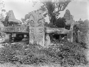
Sumba is one of the last places on Earth where people still build megalithic monuments, like large stone tombs called dolmens, for burials. More than 100 new megalithic tombs are built each year! The western part of Sumba has many more dolmens than the east. For example, the village of Waingapu in West Sumba has about 1,400 dolmens.
Life in Sumba
Sumba is one of the poorer islands in Indonesia. People face some challenges, but there are efforts to help.
Water Access
Getting enough water is a big challenge, especially during the dry season. Many streams dry up, and villagers have to rely on wells. Women and children often walk several kilometers multiple times a day to fetch water. The Sumba Foundation is working to help by drilling wells and building water stations. They have also helped reduce malaria rates on the island.
Electricity
Most electricity on Sumba comes from generators that use diesel fuel. However, new projects are bringing cleaner energy. These include a wind power plant in East Sumba and a biomass power plant in West Sumba. There are also projects using solar power and small hydro-electric systems.
Exploring Sumba

Sumba offers many interesting places to visit:
- Tanggedu Waterfall (Air Terjun Tanggedu): This beautiful waterfall is about 50 kilometers northwest of Waingapu.
- Puru Kambera Beach: A lovely beach about an hour's drive northwest of Waingapu.
- Tarimbang Bay: Located 87 kilometers southwest of Waingapu, this bay is a great spot for surfers, with big waves from June to September.
- Watu Mandorak Cove: A white sandy beach with cliffs, about 42 kilometers southwest of Tambolaka. It's best to visit during the dry season.
- Walakiri Beach: About 24 kilometers east of Waingapu, famous for its unique "dancing trees."
There's also the Sumba Hospitality Foundation in West Sumba. This organization helps young people from Sumba get training in the hospitality industry.
Resorts
NIHI Sumba is a well-known eco-hotel on the island. It has been recognized as one of the world's best hotels for its natural feel and local experience.
See also
 In Spanish: Sumba para niños
