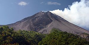
Mount Merapi facts for kids
Quick facts for kids Mount Merapi |
|
|---|---|
| Gunung Merapi | |
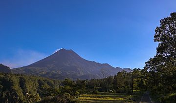
Mount Merapi, as of 2018
|
|
| Highest point | |
| Elevation | 2,910 m (9,550 ft) |
| Prominence | 1,356 m (4,449 ft) |
| Listing | Ribu |
| Naming | |
| English translation | Mountain of Fire |
| Language of name | Indonesian |
| Geography | |
| Geology | |
| Age of rock | 400,000 years |
| Mountain type | Active Stratovolcano |
| Last eruption | Ongoing |
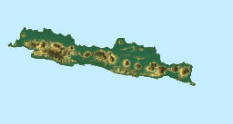
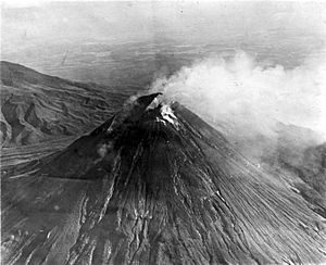
Mount Merapi, also known as Gunung Merapi, means "Fire Mountain" in Indonesian and Javanese. It is a very active stratovolcano (a cone-shaped volcano built up by many layers of hardened lava and ash). Merapi sits on the border between the provinces of Central Java and the Special Region of Yogyakarta in Indonesia.
This volcano is Indonesia's most active, erupting often since 1548. It is located about 28 kilometers (17 miles) north of Yogyakarta city, which has a population of 2.4 million people. Thousands of people live on the sides of the volcano, with some villages as high as 1,700 meters (5,600 feet) above sea level.
You can often see smoke coming from Merapi's top. Several eruptions have caused deaths. For example, a fast-moving cloud of hot gas and ash, called a pyroclastic flow, killed 27 people in 1994. Another big eruption happened in 2006. Because Merapi is so dangerous to nearby towns, it was named one of the Decade Volcanoes. These are volcanoes that scientists watch closely because they pose a significant risk.
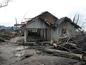
On October 25, 2010, Merapi erupted strongly. Over the next month, 353 people died, and 350,000 had to leave their homes. Most of the damage came from pyroclastic flows. Heavy rain later caused mudflows, called lahars, which added to the destruction. Merapi's shape even changed, becoming 38 meters (125 feet) shorter. Since 2010, Merapi has had smaller eruptions, and volcanologists (scientists who study volcanoes) continue to watch it closely.
Contents
What Does Merapi Mean?
The name Merapi comes from two words. Meru is a Sanskrit word meaning "mountain," and api is a Javanese word meaning "fire." So, Merapi roughly translates to "Mountain of Fire" or "Fire Mountain."
Merapi's Past: A Look at Its History
How Merapi Was Formed
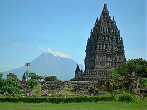
Merapi is the newest volcano in a group found in southern Java. It sits where the Indo-Australian Plate is sliding under the Sunda Plate. This area is called a subduction zone. Indonesia has at least 129 active volcanoes, and Merapi is part of the "Pacific Ring of Fire." This is a zone of fault lines that stretches from the Western Hemisphere through Japan and Southeast Asia.
Scientists believe Merapi started erupting about 400,000 years ago. For a long time, its eruptions were mostly slow flows of lava. But for the last 10,000 years, eruptions have become more explosive. Thick lava often forms lava domes (a dome-shaped mound created by slow-moving lava). When these domes collapse, they create dangerous pyroclastic flows. Bigger explosions can also send ash columns high into the sky, which can then collapse and form pyroclastic flows.
Usually, small eruptions happen every two to three years. Larger eruptions occur about every 10 to 15 years. Some big eruptions that caused many deaths happened in 1006, 1786, 1822, 1872, and 1930. In 1930, 13 villages were destroyed, and 1,400 people died from pyroclastic flows.
The very large eruption in 1006 is said to have covered all of central Java with ash. Some people believe this volcanic disaster led to the fall of the Hindu Mataram Kingdom. However, there isn't enough proof from that time to be sure.
The 2006 Eruption
In April 2006, scientists noticed more earthquakes around Merapi. This, along with a bulge in the volcano's cone, showed that new eruptions were coming. People in nearby villages were warned, and many prepared to leave. By early May, lava began to flow. On May 11, about 17,000 people were told to evacuate. On May 13, Indonesian officials raised the alert to the highest level, telling everyone on the mountain to leave immediately. However, many villagers went back to their homes, worried about their animals and crops.
On May 27, a strong earthquake (magnitude 6.3) hit about 50 kilometers (31 miles) southwest of Merapi. This earthquake killed at least 5,000 people and left 200,000 homeless in the Yogyakarta area. People worried it would make Merapi erupt even more. On June 6, another 11,000 villagers were evacuated as lava and superheated gas clouds flowed down the volcano. These pyroclastic flows are known locally as "wedhus gembel," meaning "shaggy goat." Two people died during this eruption.
The 2010 Eruption
In September 2010, scientists noticed more and more earthquakes at Merapi. On September 13, white plumes of smoke were seen rising 800 meters (2,600 feet) above the crater. The lava dome inside the volcano was also growing faster. On September 20, the alert level was raised to 2 (out of 4). By October 23–24, lava began flowing down a river, showing that a big eruption was likely very soon.
On October 25, 2010, the Indonesian government raised the alert for Mount Merapi to its highest level (4). People living within 10 kilometers (6 miles) of the volcano were told to evacuate. This affected at least 19,000 people. Officials said about 500 volcanic earthquakes had been recorded, meaning the magma (molten rock) had risen close to the surface.
After many strong eruptions, the activity started to slow down by November 10, 2010. By this time, 153 people had died, and 320,000 were displaced. However, the eruptions picked up again, keeping the alert level at 4. By November 18, the death toll reached 275. By November 24, it was 324, as more victims died from severe burns and more bodies were found.
By December 3, 2010, the death toll had risen to 353. On that day, officials lowered Merapi's alert status to Level III (Caution Alert). They warned that hot ash clouds and glowing material could still be a danger. They also said that people should not be in areas prone to disaster and kept an exclusion zone of 2.5 kilometers (1.5 miles) around the volcano.
The 2018 Eruption
A phreatic eruption (an eruption caused by steam, not new magma) happened on the morning of May 11, 2018. This led to people being evacuated from areas within 5 kilometers (3 miles) of the volcano. The airport in Yogyakarta was closed because of the ash cloud. This eruption started a new period of lava dome growth. It also led to new evacuations at Merapi in November 2020, as the danger of pyroclastic flows increased.
The 2021 Eruption
Eruptions began on January 4, 2021, causing more evacuations in the Yogyakarta region. The geological authority had raised the alert level in November 2020 after sensors showed increasing activity. On March 27, 2021, another small eruption occurred, sending out lava and pyroclastic flows. Merapi erupted again on August 8, 2021, with new lava flows. On August 16, 2021, the volcano erupted once more, releasing an ash cloud and red lava. These explosions sent clouds as far as 3.5 kilometers (2 miles) away, covering local communities in grey ash.
On December 9, a pyroclastic flow traveled 2.2 kilometers (1.4 miles) down a river. This happened shortly after another volcano, Semeru, erupted to the east, killing at least 43 people.
How Merapi Is Watched
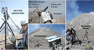
Mount Merapi is one of the most closely watched volcanoes in the world. Scientists started monitoring its earthquakes in 1924. Over the years, monitoring stations have been updated with new equipment. Some stations were even moved after eruptions, like the one in 1994, to keep the scientists safe. The Deep Earth Carbon Degassing Project also helps monitor this volcano.
Scientists found that the 1930 eruption was preceded by many small earthquakes. A network of 8 seismographs (instruments that detect ground motion) around the volcano now helps scientists pinpoint where tremors and quakes start.
There's a zone about 1.5 kilometers (0.9 miles) below the summit where no quakes happen. Scientists believe this is where the magma chamber (a large underground pool of molten rock) is located, which feeds the eruptions.
Other measurements taken on the volcano include magnetic and tilt measurements. Small changes in the local magnetic field can happen during eruptions. Tilt measurements show how the volcano's surface swells when the magma chambers beneath it are filling up.
Lahars (a type of mudflow made of volcanic ash and water) are a big danger on the mountain. They happen when rain mixes with pyroclastic flow deposits. Lahars can be detected by seismic instruments because they create a high-frequency signal. Observations show that about 50 millimeters (2 inches) of rain per hour is enough to create lahars.
Sabo Dams
There are about 258 sand barriers, called sabo dams, around Merapi. These dams are built to control and slow down lahars. About 90 of these dams were damaged during eruptions. It costs a lot of money to repair them.
Restricted Zone
After the 2010 eruption, the Indonesian government created a "prohibited zone." This means that no one can live permanently in nine villages in the Cangkringan district, and no new buildings are allowed there.
Merapi National Park
In 2004, an area of 6,410 hectares (about 15,800 acres) around Mount Merapi was made into a national park. However, some local residents challenged this decision in court. They felt they were not properly consulted. During the 2006 eruption, many residents were hesitant to leave their homes because they feared their land would be taken for the park's expansion.
Merapi Museum
- The Merapi Museum Center is located on Kaliurang Street Kilometer 25.7, in the Pakem subdistrict of Sleman, Yogyakarta. The museum has a replica of Merapi after its 2010 eruption. Many Indonesian students visit the museum, especially since the latest eruption.
Merapi's Myths and Legends
Mount Merapi is very important to the Javanese people, especially those who live near its crater. Because of this, many myths and beliefs are connected to Merapi.
How Merapi Was Created
Most villages near Merapi have their own stories about how the mountain was created, but they share many common ideas. It is believed that when the gods first made the Earth, the island of Java was unbalanced because of a mountain called Mount Jamurdipo on its west side. To fix this, the gods ordered the mountain to be moved to the center of Java. However, two skilled metalworkers, Empu Rama and Empu Permadi, were already making a special dagger called a keris where Mount Jamurdipo was to be moved. The gods warned them to leave, but Empu Rama and Empu Permadi ignored the warning. In anger, the gods buried them under Mount Jamurdipo. Their spirits then became the rulers of all mystical beings in the area. To remember them, Mount Jamurdipo was later renamed Mount Merapi, which means "fire of Rama and Permadi."
The Spirit Palace of Merapi
The Javanese believe that the Earth is home not only to humans but also to spirits (makhluk halus). Villages near Merapi believe that one of the palaces (called a kraton in Javanese) used by the rulers of the spirit kingdom is inside Merapi. This palace is said to be ruled by Empu Rama and Empu Permadi. It is believed to be a spiritual version of the Yogyakarta Sultanate, complete with roads, soldiers, princes, vehicles, and even animals. Besides the rulers, the palace is also said to be home to the spirits of ancestors who lived good lives. These ancestor spirits are believed to live in the palace as royal servants (abdi dalem). Sometimes, they visit their descendants in dreams to give prophecies or warnings.
The Spirits of Merapi
To keep the volcano quiet and to please the mountain spirits, the Javanese regularly bring offerings. They do this on the anniversary of the sultan of Yogyakarta's coronation. For the Yogyakarta Sultanate, Merapi has a very important meaning. It forms a sacred line from the Merapi peak in the north to the Southern Ocean (Indian Ocean). This sacred line includes the Tugu Yogyakarta monument, Malioboro street, the Northern Alun-alun (square), the Keraton Yogyakarta (sultan's palace), the Southern Alun-alun, and finally reaches the beaches of Samas and Parangkusumo on the Southern Ocean. This sacred line connects the mountain spirits, often called "Mbah Petruk" by Javanese people, with the Sultan of Yogyakarta (the leader of the Javanese kingdom), and Nyi Roro Kidul (the queen of the Southern Ocean, a mythical sea goddess and consort of Javanese kings).
See also
 In Spanish: Monte Merapi para niños
|
 | James B. Knighten |
 | Azellia White |
 | Willa Brown |


