Kelud facts for kids
Quick facts for kids Kelud |
|
|---|---|
 |
|
| Highest point | |
| Elevation | 1,731 m (5,679 ft) |
| Listing | List of volcanoes in Indonesia |
| Geography | |
| Geology | |
| Mountain type | Stratovolcano |
| Volcanic arc | Sunda Arc |
| Last eruption | 13 February 2014 |
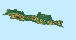
The Kelud (also known as Kelut or Kloet) is a towering stratovolcano located in Kediri, East Java, Indonesia. A stratovolcano is a tall, cone-shaped volcano built up by many layers of hardened lava, ash, and rock. It is classified as a young stratovolcano, and its current edifice has been built up over approximately the last 5,000 to 10,000 years.
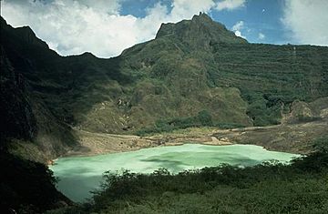
Like many volcanoes around the Pacific Ring of Fire, Kelud is famous for its powerful and explosive eruptions. Over 30 eruptions have happened since the year 1000 AD. In 2007, a slow eruption created a lava dome inside its crater. A lava dome is a mound of thick, sticky lava that slowly piles up around a volcano's vent. Its most recent eruption was on 13 February 2014. This eruption destroyed the lava dome and sent rocks, stones, and ash flying as far as West Java, about 500 kilometers (310 miles) away. During the rainy season, the crater often fills with water.
Contents
About Mount Kelud
Mount Kelud is a very active volcano with a long history of eruptions. It is part of the Sunda Arc, a chain of volcanoes formed by tectonic plates colliding. Its eruptions have shaped the landscape and affected the lives of people in East Java for centuries.
Early Eruptions and History
The history of Kelud's eruptions is special because some of its activities were written down in old Indonesian stories.
The 1334 Eruption
One of the earliest recorded eruptions happened in 1334 CE. This was the same year that King Hayam Wuruk of Majapahit was born. An ancient text called Nagarakretagama mentioned this event. People at that time believed that the eruption was a special sign from the gods, showing that their king was very important. This shows how much people in Java connected natural events like eruptions with divine messages.
The 1586 Eruption
In 1586, Mount Kelud had one of its most deadly eruptions. This event caused the deaths of over 10,000 people. It was a tragic reminder of the volcano's immense power.
Dealing with Danger: The 1919 Mudflows
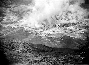
On May 19, 1919, another eruption at Kelud caused a disaster. About 5,000 people lost their lives, mostly due to hot mudflows. These dangerous mudflows are also known as "lahars". Lahars are fast-moving mixtures of volcanic ash, rock, and water that flow down the sides of a volcano. Later eruptions in 1951, 1966, and 1990 also caused more deaths. After the 1966 eruption, special tunnels called the Ampera Tunnels were built. These tunnels helped to lower the water level in the crater lake. By reducing the water, they aimed to make future lahars less dangerous.
The 1990 Eruption: A Powerful Blast
In early February 1990, Mount Kelud had a very strong and explosive eruption. It sent a column of ash and rock, called tephra, seven kilometers (about 4.3 miles) into the sky. Heavy tephra fell over the area, and several pyroclastic flows rushed down the slopes. Pyroclastic flows are fast-moving currents of hot gas and volcanic debris. More than thirty people died in this eruption. Workers continued to build the Ampera Tunnel even though the pyroclastic flow deposits were still very hot and up to 25 meters (82 feet) high. This eruption also sadly killed over 300 monkeys in the nearby forests.
The 2007 Eruption: A Slow Change
On October 16, 2007, Indonesian officials told about 30,000 people living near Kelud to leave their homes. Scientists had put the volcano on the highest alert level, meaning an eruption was expected soon.
Kelud began to erupt around 3 p.m. local time on November 3. Scientists confirmed the eruption using seismic readings, which are measurements of ground vibrations. Even though clouds covered the peak, the readings showed the volcano was active. Many people lived within 10 kilometers (6 miles) of the volcano. Surabaya, a large city, is about 90 kilometers (56 miles) away. Many residents had not evacuated or had returned home. Some villagers fled in a panic after hearing about the eruption. However, officials later said the eruption that day was not very large.
On the morning of November 4, Mount Kelud spewed ash 500 meters (1,640 feet) into the air. This showed that a full eruption was happening. Scientists noticed that the surface temperature of the crater lake rose significantly. The extreme heat created a cloud of steam and smoke 488 meters (1,600 feet) high.
On November 5, more smoke and steam came from the crater. Boiling water flowed down the mountain from the lake. Many people remained in the danger zone, ignoring evacuation orders.
The next day, a lava dome began to rise through the center of the crater lake. Cameras showed an oblong island, about 100 meters (328 feet) long, pushing about 20 meters (66 feet) above the lake's surface. The volcano continued to release smoke, with plumes reaching 1,000 meters (3,280 feet) into the atmosphere.
After 48 hours of smoke and ash but no lava, officials announced on November 8 that a large explosion was not expected immediately. They said the volcano was having a "slow eruption" and was unlikely to explode as it had in the past.
By November 12, Mount Kelud started to release lava into its crater lake. The lava dome had grown to 250 meters (820 feet) long and 120 meters (394 feet) high. It cracked open, and lava began to flow into the water. Smoke rose more than 2 kilometers (1.2 miles) into the air, and ash fell on several villages. By November 14, the hot lava dome had filled the crater, and the lake disappeared.
The 2014 Eruption: Ash Across Java
| 2014 eruption of Kelud | |
|---|---|
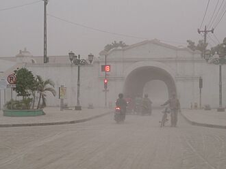
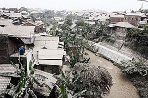
Ashfall in Yogyakarta from the Kelud eruption in February 2014
|
|
| Type | Plinian |
| VEI | 4 |
Mount Kelud erupted again on February 13, 2014, at 10:50 p.m. local time. This was a powerful eruption, rated as a VEI 4. The Volcanic Explosivity Index (VEI) measures the size of volcanic eruptions, with 4 being a large eruption. This event sent volcanic ash over an area about 500 kilometers (310 miles) wide. The total amount of material ejected was estimated to be between 120 million and 160 million cubic meters. Ashfall covered a large part of Java island, including Malang, Central Java, and Yogyakarta.
About 76,000 people had to leave their homes. Sadly, two people died when their houses collapsed from the heavy ash. An elderly man also passed away from breathing in the ash. Ash even reached the western part of Java, with traces found in Bandung and nearby areas.
Impact on Daily Life
The ashfall from the 2014 eruption caused major problems across Java. Seven airports, including those in Yogyakarta, Surakarta, and Surabaya, had to close. These closures led to significant financial losses for businesses. Many manufacturing and agricultural industries were also badly affected. For example, apple orchards in Batu lost a lot of money, and the dairy industry faced high losses.
Major tourist spots in Yogyakarta and Central Java, like Borobudur, Prambanan, and Ratu Boko, were closed to visitors. These sites were heavily covered in volcanic ash, even though they are about 200 kilometers (124 miles) east of Kelud. Workers covered the famous stupas and statues of Borobudur temple to protect them. Many tourists canceled their hotel bookings, causing hotels in Yogyakarta to lose a lot of money.
Recovery and Rebuilding
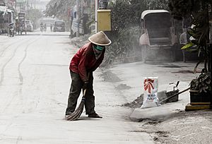
After the eruption, cleanup efforts began quickly. The Indonesian military used water cannons to clear roads and helped with rebuilding in the areas around Kelud. Local citizens also helped clean up, though with simpler tools. Ash from Yogyakarta was placed in fields in nearby villages. Local groups and helpers gave food to people affected by the eruptions. By February 20, most businesses and attractions that had closed due to the ashfall had reopened, even though cleaning was still ongoing.
The volcano's alert status was lowered on February 21, and the safe zone around it was reduced from 10 kilometers (6 miles) to 5 kilometers (3 miles). By early March, most of the 12,304 buildings that were destroyed or damaged had been repaired. The estimated cost for these repairs was about 55 billion rupiah (US$5.5 million).
See also
 In Spanish: Kelut para niños
- List of volcanoes in Indonesia
- List of volcanic eruptions by death toll
 | May Edward Chinn |
 | Rebecca Cole |
 | Alexa Canady |
 | Dorothy Lavinia Brown |


