
Mount Rinjani facts for kids

Mount Rinjani (also called Gunung Rinjani) is an active volcano found on the island of Lombok, Indonesia. It stands tall at 3,726 metres (12,224 ft), making it the second highest volcano in Indonesia.
At the very top of Mount Rinjani is a huge bowl-shaped area called a caldera. This caldera is about 6-by-8.5-kilometre (3.7 by 5.3 mi) wide. Part of it is filled by a beautiful crater lake named Segara Anak. This name means Child of the Sea because its water is as blue as the ocean. The lake is about 2,000 metres (6,600 ft) above sea level and is thought to be around 200 metres (660 ft) deep. You can also find hot springs in the caldera. Local people, like the Sasak tribe and Hindus, believe the lake and the mountain are very special and sacred. They sometimes hold religious events there. Mount Rinjani erupted on September 27, 2016. In April 2018, UNESCO recognized Mount Rinjani Caldera as part of its Global Geoparks Network.
Contents
What is Mount Rinjani's History?
The Big Eruption of 1257
Scientists believe that the huge caldera of Mount Rinjani was formed during a massive eruption in the 13th century. This event, known as the 1257 Samalas eruption, happened around the "late spring or summer of 1257." Many experts think this was the strongest volcanic blast since people started writing things down! This powerful eruption might have even caused a period of global cooling and led to bad harvests around the world. Before this big eruption, the area where Segara Anak lake now sits was a volcanic mountain called Samalas, which was even taller than Rinjani is today.
Changes Over Time
Over the past 10,000 years, before the caldera was formed, the way Rinjani erupted changed a lot. This included how often it erupted, where the eruptions happened, what kind of eruptions they were, and even the type of magma (molten rock) that came out.
Recent Eruptions and New Mountains
The first eruption that people recorded happened in September 1847. More recently, eruptions in 1994 and 1995 created a new cone inside the caldera. This cone is called Gunung Baru (meaning 'New Mountain') and is about 2,300 metres (7,500 ft) above sea level. Lava from later eruptions has flowed into the lake. This new cone is now known as Gunung Barujari.
The most recent eruption of Mount Rinjani was in May 2010. Other important eruptions happened between 1994 and 1995, which helped Gunung Barujari grow even more. All recorded eruptions at Rinjani since 1847 have come from the Barujari cone and another small dome called Rombongan (in 1944). These eruptions usually involved moderate explosions and sometimes lava flows that reached the Segara Anak lake. We don't have records of Rinjani's eruptions before 1847 because the island of Lombok was a very remote place back then.
Volcanic Mudflows
On November 3, 1994, a dangerous lahar (which is like a fast-moving volcanic mudflow) rushed down from the top of Rinjani. It traveled along the Kokok Jenggak River. Sadly, thirty people from the village of Aikmel were caught by surprise while collecting water from the river and were affected by the flow.
Safety Levels
Because of the eruptions from the Gunung Barujari cone, the safety level for Mount Rinjani was raised. On May 2, 2009, it went from 'Normal' to 'be vigilant'. In May 2010, the Center for Volcanology & Geological Hazard Mitigation in Indonesia put Mount Rinjani on 'standby' status. They advised people to stay at least 4 kilometres (2.5 mi) away from the eruption site at Gunung Barujari.
Images for kids
-
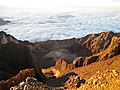
A view from the very top of Gunung Rinjani.
-
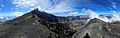
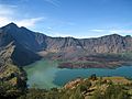
From this spot at 2,600m on the eastern ridge, you can see the summit, the ash cone, and the lake.
-
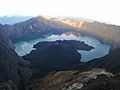
Segara Anak, the beautiful volcanic crater lake at the top of Rinjani.
-
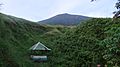
A hiking post on Tengengean, at 1500 meters high on Mount Rinjani.
-
A view of Segara Anak lake from the edge of the crater.


See also
 In Spanish: Monte Rinjani para niños
