Moxie Falls facts for kids
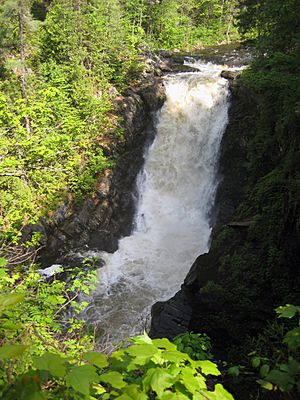
Moxie Falls is a really tall waterfall located in Somerset County, Maine. It drops over 90 feet (about 27 meters) into a deep pool, making it one of the highest waterfalls in all of New England!
The water for Moxie Falls comes from Moxie Stream. This stream flows from Moxie Pond and eventually joins the Kennebec River about 1 kilometer (or 0.6 miles) away. Moxie Stream starts about 5 miles (8 kilometers) upstream from the falls, draining Moxie Pond.
If you want to visit, there's a hiking trail about 0.5 miles long. At the end, a boardwalk lets you get a great view of the falls. Plus, there are some cool pools upstream where you can even go for a swim!
Moxie Pond: The Source of the Falls
Quick facts for kids Moxie Pond |
|
|---|---|
| Lua error in Module:Location_map at line 420: attempt to index field 'wikibase' (a nil value). | |
| Location | Somerset County, Maine |
| Primary outflows | Moxie Stream |
| Basin countries | United States |
| Max. length | 7.5 mi (12.1 km) |
| Surface area | 2,229 acres (902 ha) |
| Water volume | 28,537 acre⋅ft (35,200,000 m3) |
| Surface elevation | 970 ft (300 m) |
Moxie Pond, sometimes called Lake Moxie, is a long, narrow lake. It stretches about 7.5 miles (12 kilometers) from north to south. The pond helps form the border between two areas: The Forks Plantation on its west side and East Moxie Township on its east side.
Streams Flowing into Moxie Pond
Many smaller streams feed into Moxie Pond, bringing water from the surrounding areas.
- Baker Stream: This stream flows into the southern end of Moxie Pond. The famous Appalachian Trail crosses Baker Stream here. Baker Stream itself gets water from Baker Pond, which is about 1 mile (1.6 kilometers) upstream. Baker Pond also receives water from Dimmick Stream, which starts on Moxie Mountain and flows through Big Dimmick Pond and Little Dimmick Pond. Other water sources for Baker Stream include Moxie Bog and Wild Brook.
- Mosquito Stream: This stream is about 4 miles (6.4 kilometers) long. It flows from Mosquito Mountain, through Mosquito Pond, and then into Moxie Pond.
- Little Sandy Stream: This stream is about 2.5 miles (4 kilometers) long and flows into the west side of Moxie Pond.
- East Side Streams: Several other streams flow into the east side of Moxie Pond. These include Alder Stream (5 miles or 8 kilometers long), Big Sandy Stream (5 miles or 8 kilometers long), Bear Brook (3 miles or 4.8 kilometers long), and Bald Mountain Brook (2 miles or 3.2 kilometers long).
History of the Railroad Near Moxie Pond
A railroad line, called the Maine Central Railroad Kineo branch, was built along the west side of Moxie Pond in 1906. This railroad helped connect a sawmill located at the northern end of the pond. It also had a special branch that went to Bald Mountain to help with logging. However, the railroad was taken apart in 1933.
 | Kyle Baker |
 | Joseph Yoakum |
 | Laura Wheeler Waring |
 | Henry Ossawa Tanner |


