
Mud Island, Michigan facts for kids

USGS aerial imagery of Mud Island
|
|

Mud Island
Location in Wayne County, Michigan

Mud Island
Location in Michigan

Mud Island
Location in the United States
|
|
| Geography | |
|---|---|
| Location | Michigan |
| Coordinates | 42°14′20″N 83°08′27″W / 42.23889°N 83.14083°W |
| Highest elevation | 584 ft (178 m) |
| Administration | |
|
United States
|
|
| State | |
| County | Wayne |
Mud Island is a small island located in the Detroit River. This river forms part of the border between the United States and Canada. Mud Island is found in Wayne County, which is in the southeastern part of Michigan.
The island's exact location is at coordinates 42°14′20″N 83°08′27″W / 42.23889°N 83.14083°W. In 1980, the United States Geological Survey measured its elevation. They found that Mud Island is about 584 ft (178 m) above sea level.
Location and Features
Mud Island sits within the busy Detroit River. This river connects Lake St. Clair to Lake Erie. Islands like Mud Island are often formed by river currents or sediment buildup.
Part of Wayne County
The island is officially part of Wayne County. This county is home to the city of Detroit. Mud Island is one of several islands in this area.
Elevation Details
The elevation of 584 ft (178 m) means how high the island is. This measurement was taken by the United States Geological Survey (USGS). The USGS is a science agency that studies the Earth.
Images for kids
-
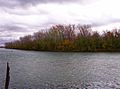
View of Mud Island from John D. Dingell Park in Ecorse

