Mulberry, Oklahoma facts for kids
Quick facts for kids
Mulberry, Oklahoma
|
|
|---|---|

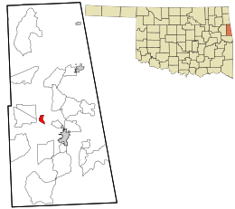
Location within Adair County and the state of Oklahoma
|
|
| Country | United States |
| State | Oklahoma |
| County | Adair |
| Area | |
| • Total | 0.94 sq mi (2.42 km2) |
| • Land | 0.93 sq mi (2.42 km2) |
| • Water | 0.00 sq mi (0.00 km2) |
| Elevation | 984 ft (300 m) |
| Population
(2020)
|
|
| • Total | 96 |
| • Density | 102.78/sq mi (39.68/km2) |
| Time zone | UTC-6 (Central (CST)) |
| • Summer (DST) | UTC-5 (CDT) |
| FIPS code | 40-49825 |
| GNIS feature ID | 2584385 |
Mulberry is a small community in Adair County, Oklahoma, in the United States. It is officially known as a census-designated place (CDP). This means it's a special area defined by the government for gathering information, but it doesn't have its own local government like a city or town. In 2020, about 96 people lived there.
Where is Mulberry?
Mulberry is found in the eastern part of Oklahoma. It sits right next to Oklahoma State Highway 51, which is an important road.
The community is about 6 miles (10 km) northwest of Stilwell. Stilwell is the main town, or county seat, for Adair County. Mulberry is also about 18 miles (29 km) east of Tahlequah. Tahlequah is a larger city in Cherokee County.
Mulberry covers a total area of about 0.93 square miles (2.4 square kilometers). All of this area is land.
Who Lives in Mulberry?
| Historical population | |||
|---|---|---|---|
| Census | Pop. | %± | |
| 2020 | 96 | — | |
| U.S. Decennial Census | |||
In 2020, the census counted 96 people living in Mulberry. This number helps us understand how many people call Mulberry home.
See also
 In Spanish: Mulberry (Oklahoma) para niños
 | Jessica Watkins |
 | Robert Henry Lawrence Jr. |
 | Mae Jemison |
 | Sian Proctor |
 | Guion Bluford |

