Mundarlo, New South Wales facts for kids
Quick facts for kids MundarloNew South Wales |
|
|---|---|

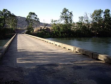
Mundarlo - Murrumbidgee River crossing
|
|
| Population | 51 (2021 census) |
| Postcode(s) | 2729 |
| Elevation | 303 m (994 ft) |
| Location |
|
| LGA(s) | Cootamundra Gundagai Regional Council |
| County | Wynyard |
| State electorate(s) | Wagga Wagga |
| Federal Division(s) | Riverina |
Mundarlo is a small farming community located in the central east part of the Riverina region in New South Wales, Australia. It is about 13 kilometres (8 miles) south-east of Wantabadgery and 18 kilometres (11 miles) north-west of Tumblong. In 2021, only 51 people lived in Mundarlo.
Exploring Mundarlo
Mundarlo is special because it sits right on the southern bank of the Murrumbidgee River. This river is very important to the area. A low concrete bridge helps people cross the river here.
The Murrumbidgee River Crossing
The Murrumbidgee River is one of Australia's longest rivers. It flows through Mundarlo. The bridge at Mundarlo is a "low level" crossing. This means it is built close to the water. It helps farmers and other locals travel across the river. This connection is vital for the community.
A Glimpse into Mundarlo's Past
Mundarlo has a little bit of history. A Post Office opened here on 1 February 1872. Back then, it was spelled "Mundarloo." However, it closed just one year later. In the past, post offices were very important. They were the main way for people to send letters and connect with others.
 | Percy Lavon Julian |
 | Katherine Johnson |
 | George Washington Carver |
 | Annie Easley |


