Munith, Michigan facts for kids
Quick facts for kids
Munith, Michigan
|
|
|---|---|

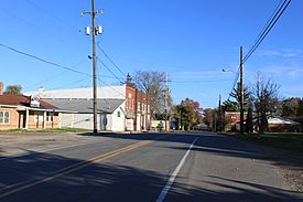
Looking north along Main Street
|
|
| Country | United States |
| State | Michigan |
| County | Jackson |
| Townships | Henrietta and Waterloo |
| Elevation | 942 ft (287 m) |
| Time zone | UTC-5 (Eastern (EST)) |
| • Summer (DST) | UTC-4 (EDT) |
| ZIP code(s) |
49259
|
| Area code(s) | 517 |
| FIPS code | 26-56260 |
| GNIS feature ID | 633123 |
Munith is a small, friendly place located in Jackson County, in the state of Michigan. It's known as an unincorporated community, which means it doesn't have its own separate city government. Instead, it's part of larger areas called Waterloo Township and Henrietta Township.
You can find Munith along M-106, a main road that runs through the area. Its exact location is at 42°23′26″N 84°15′02″W / 42.39056°N 84.25056°W.
Contents
What Makes Munith Special?
Munith is a quiet community with a few important places that serve its residents. Even though it's small, it has everything people need for daily life.
Local Services and Businesses
- Post Office: Munith has its own post office, which is super helpful for sending and receiving mail.
- Township Hall: This building is where local government meetings happen for the townships that Munith is part of.
- Cemetery: A peaceful place for remembering those who have passed away.
- Gas Station/Convenience Store: Perfect for quick stops to fill up your car or grab a snack.
- Farmers State Bank: This bank is a local business that helps people with their money. It's a member of the FDIC, which means your money is safe there.
- No Stoplights: One interesting fact about Munith is that it doesn't have any stoplights! This shows how small and calm the community is.
Education in the Area
Students living in the Munith area attend different schools, depending on exactly where they live. The community is served by three different school districts:
- Stockbridge Community Schools
- Northwest Community Schools
- East Jackson Community Schools
Places of Worship
Munith is home to two Christian churches where people can gather for services and community events:
- Munith United Methodist Church, located on Main Street.
- Jeruel Baptist Church, found along M-106.
Getting Around Munith
The main way to identify locations in Munith is through its ZIP Code. The ZIP Code for Munith is 49259. This code helps the postal service deliver mail to homes and businesses in both Henrietta and Waterloo townships.
 | Shirley Ann Jackson |
 | Garett Morgan |
 | J. Ernest Wilkins Jr. |
 | Elijah McCoy |


