Munshausen facts for kids
Quick facts for kids
Munshausen
Munzen
|
||
|---|---|---|
|
Former commune
|
||
 |
||
|
||

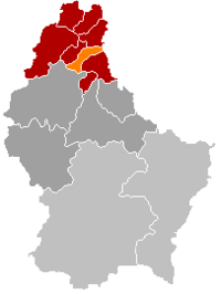
Map of Luxembourg with Munshausen highlighted in orange, and the canton in dark red
|
||
| Country | ||
| Canton | Clervaux | |
| Time zone | UTC+1 (CET) | |
| • Summer (DST) | UTC+2 (CEST) | |
| Website | munshausen.lu | |
Munshausen (called Munzen in Luxembourgish) is a small village in the northern part of Luxembourg. It is now part of a larger area known as the commune of Clervaux.
Before 2009, Munshausen was its own independent commune. A commune is like a local government area, similar to a small town or district. In 2009, Munshausen joined with Clervaux to form a bigger commune.
As of 2023, about 261 people live in the village of Munshausen.
Munshausen's Past as a Commune
When Munshausen was its own commune, it included several smaller villages. These villages were:
- Drauffelt (also known as Draufelt)
- Marnach (also known as Maarnech)
- Munshausen (the main village, also known as Munzen)
- Roder (also known as Rueder)
- Siebenaler (also known as Siwwenaler)
Exploring Munshausen's Location
Munshausen is located in the northeastern part of Luxembourg. To the east, a river called the Our forms a natural border with Germany.
This area is part of a region known as the Oesling. The Oesling is the Luxembourgish section of the Ardennes mountains. The landscape here features flat areas, like high plains, that are about 1,650 feet (500 meters) above sea level. These plains are cut through by narrow river valleys.
A line running between the towns of Hosingen and Heinerscheid, which passes through Marnach, helps divide the water flow. To the west, rivers flow into the Clerve river. To the east, they flow into the Our river.
 | George Robert Carruthers |
 | Patricia Bath |
 | Jan Ernst Matzeliger |
 | Alexander Miles |


