Murphy, Idaho facts for kids
Quick facts for kids
Murphy, Idaho
|
|
|---|---|

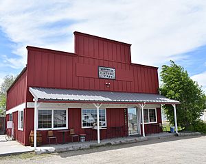
The Murphy General Store and Cafe, May 2019
|
|

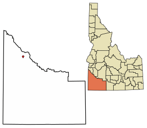
Location of Murphy in Owyhee County, Idaho.
|
|
| Country | United States |
| State | Idaho |
| County | Owyhee |
| Area | |
| • Total | 3.839 sq mi (9.94 km2) |
| • Land | 3.839 sq mi (9.94 km2) |
| • Water | 0 sq mi (0 km2) |
| Elevation | 2,820 ft (860 m) |
| Population
(2020)
|
|
| • Total | 96 |
| • Density | 25.01/sq mi (9.66/km2) |
| Time zone | UTC-7 (Mountain (MST)) |
| • Summer (DST) | UTC-6 (MDT) |
| ZIP codes |
83650
|
| Area code(s) | 208, 986 |
| FIPS code | 16-55720 |
Murphy is a small community in Idaho, United States. It is known as a census-designated place, which means it's an area identified by the government for statistics. Murphy is also the main town, or county seat, for Owyhee County.
With only 96 people counted in 2020, Murphy is one of the smallest county seats in the entire country. It is part of the larger Boise City–Nampa Metropolitan Statistical Area. Murphy is also home to the Owyhee County Historical Museum and Library, where you can learn about the area's past.
Contents
Discovering Murphy's Past: A Look at Its History
Murphy started to grow because of a railroad. In 1899, Colonel William H. Dewey built the Boise, Nampa and Owyhee Railroad. This railroad ended in Murphy. Dewey had planned to extend the tracks to Silver City. However, the mines in the Owyhee Mountains stopped producing much, so the railroad was not built any further. The train line operated until 1947.
How Murphy Became the County Seat
In 1934, people in Owyhee County voted for Murphy to become the new county seat. Before this, Silver City was the county seat, but it was getting smaller and smaller. Even though the county seat moved to Murphy, and a new courthouse was built in 1936, the change wasn't officially approved by the Idaho State Legislature until 1999. This mistake in the state's laws was finally fixed many years later.
The Origin of Murphy's Name
The community of Murphy was likely named after Cornelius "Con" Murphy. He was a crew boss for the Boise, Nampa and Owyhee Railroad. He also worked as a foreman when the Guffey Bridge was built in 1897. Another idea is that the town was named after Pat Murphy. He was a mining engineer from Silver City and a friend of the railroad owner, Dewey.
Understanding Murphy's Population Changes
| Historical population | |||
|---|---|---|---|
| Census | Pop. | %± | |
| 1900 | 80 | — | |
| 1910 | 102 | 27.5% | |
| 1920 | 150 | 47.1% | |
| 1930 | 75 | −50.0% | |
| 1950 | 50 | — | |
| 1960 | 50 | 0.0% | |
| 1970 | 100 | 100.0% | |
| 1980 | 150 | 50.0% | |
| 1990 | 150 | 0.0% | |
| 2010 | 97 | — | |
| 2020 | 96 | −1.0% | |
| source: | |||
The population of a place tells us how many people live there. Murphy has always been a small community. In 1900, about 80 people lived there. The population changed over the years, sometimes growing and sometimes shrinking. In 2020, the population was 96 people. This shows that Murphy remains a very small town.
Exploring Murphy's Location and Environment
Murphy is located at 43°13′06″N 116°33′08″W / 43.21833°N 116.55222°W. This means it is at a specific point on the Earth's surface. It sits at an elevation of about 2,820 feet (860 meters) above sea level. Murphy is about 25 miles (40 kilometers) south of Nampa.
Murphy's Climate: Weather Patterns
Murphy has a type of weather called a cold semi-arid climate. This means it's generally dry, but it can get cold, especially in winter. It's not as dry as a desert, but it doesn't get a lot of rain or snow.
| Climate data for Murphy, Idaho, 1991–2020 normals, extremes 2003–present | |||||||||||||
|---|---|---|---|---|---|---|---|---|---|---|---|---|---|
| Month | Jan | Feb | Mar | Apr | May | Jun | Jul | Aug | Sep | Oct | Nov | Dec | Year |
| Record high °F (°C) | 60 (16) |
65 (18) |
74 (23) |
83 (28) |
94 (34) |
103 (39) |
104 (40) |
103 (39) |
103 (39) |
88 (31) |
76 (24) |
62 (17) |
104 (40) |
| Mean maximum °F (°C) | 53.4 (11.9) |
58.4 (14.7) |
67.8 (19.9) |
77.1 (25.1) |
86.1 (30.1) |
93.6 (34.2) |
99.0 (37.2) |
97.4 (36.3) |
91.1 (32.8) |
79.3 (26.3) |
67.1 (19.5) |
56.0 (13.3) |
99.9 (37.7) |
| Mean daily maximum °F (°C) | 39.5 (4.2) |
43.6 (6.4) |
52.3 (11.3) |
58.7 (14.8) |
68.2 (20.1) |
76.9 (24.9) |
87.7 (30.9) |
86.1 (30.1) |
76.3 (24.6) |
62.1 (16.7) |
47.2 (8.4) |
38.2 (3.4) |
61.4 (16.3) |
| Daily mean °F (°C) | 30.7 (−0.7) |
33.9 (1.1) |
40.7 (4.8) |
45.6 (7.6) |
54.2 (12.3) |
61.6 (16.4) |
70.9 (21.6) |
69.5 (20.8) |
60.2 (15.7) |
48.1 (8.9) |
36.4 (2.4) |
29.4 (−1.4) |
48.4 (9.1) |
| Mean daily minimum °F (°C) | 21.8 (−5.7) |
24.3 (−4.3) |
29.0 (−1.7) |
32.5 (0.3) |
40.2 (4.6) |
46.3 (7.9) |
54.1 (12.3) |
53.0 (11.7) |
44.0 (6.7) |
34.2 (1.2) |
25.5 (−3.6) |
20.5 (−6.4) |
35.5 (1.9) |
| Mean minimum °F (°C) | 4.8 (−15.1) |
10.7 (−11.8) |
17.3 (−8.2) |
20.4 (−6.4) |
26.3 (−3.2) |
35.1 (1.7) |
43.8 (6.6) |
42.0 (5.6) |
32.2 (0.1) |
19.7 (−6.8) |
11.0 (−11.7) |
1.9 (−16.7) |
−1.9 (−18.8) |
| Record low °F (°C) | −16 (−27) |
−3 (−19) |
10 (−12) |
14 (−10) |
20 (−7) |
31 (−1) |
40 (4) |
35 (2) |
25 (−4) |
4 (−16) |
−4 (−20) |
−10 (−23) |
−16 (−27) |
| Average precipitation inches (mm) | 1.24 (31) |
0.83 (21) |
1.12 (28) |
0.98 (25) |
1.40 (36) |
1.10 (28) |
0.33 (8.4) |
0.30 (7.6) |
0.56 (14) |
0.74 (19) |
1.30 (33) |
1.40 (36) |
11.30 (287) |
| Average precipitation days (≥ 0.01 in) | 9.4 | 9.2 | 10.1 | 8.4 | 9.7 | 7.2 | 3.0 | 2.8 | 3.8 | 5.4 | 9.1 | 10.9 | 89.0 |
| Source 1: NOAA | |||||||||||||
| Source 2: National Weather Service (mean maxima/minima 2006–2020) | |||||||||||||
Murphy's Airstrip: A Local Airport
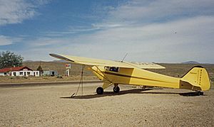
Murphy has a small airstrip located just northeast of the community. An airstrip is like a small airport, but it does not have a control tower. This means pilots communicate directly with each other. The airstrip has a 2,500-foot (760-meter) asphalt runway. It runs from northwest to southeast, parallel to State Highway 78. The elevation of the runway drops slightly from one end to the other.
See also
 In Spanish: Murphy (Idaho) para niños


