Murray Basin facts for kids
The Murray Basin is a large, shallow area of land in southeastern Australia. It covers parts of New South Wales, Victoria, and South Australia. This basin gets its name from the famous Murray River, which flows right through it from east to west.
Contents
How the Murray Basin Formed
Scientists have a cool idea about how the Murray Basin was created. They think it formed because a huge piece of oceanic crust (the Earth's outer layer under the ocean) sank deep into the Earth. This process is called subduction.
This sinking happened a very long time ago, when the Australian continent was moving north. As the slab of rock sank, it pulled down the land above it, creating a big hollow. This hollow is what we now call the Murray Basin.
Over millions of years, this hollow has slowly moved south. If this idea is correct, the Murray Basin might continue to move south and eventually disappear under the Southern Ocean!
Geologic History of the Basin
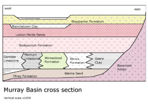
The Murray Basin started to form after Australia separated from Antarctica. The land in the basin slowly sank over time. This allowed up to 600 metres (2,000 feet) of sand, mud, and other materials to fill it up during the Cenozoic Era.
Early Seas and Sands
From about 66 to 34 million years ago, the western part of the basin was covered by seawater. This sea left behind layers of sand called the Warina sand. Later, the sea moved out, and silt and clay were deposited.
There was also a small return of the sea about 35 million years ago, which formed the Buccleuch Formation in South Australia. All these early deposits are known as the Renmark Group.
Mid-Period Sea Levels
The sea level rose again about 30 to 14 million years ago. This created the Murray Group of sediments. In deeper areas, chalky mud (marl) and limestone were formed. In shallower waters, a type of clay called Geera Clay was deposited.
When the sea level dropped again around 14 million years ago, the Geera Clay and other deposits spread westward over the limestone.
Later Sea Changes
From about 12 to 2.5 million years ago, the sea level went up and down several times. The first time the sea rose, it formed the Murravian Gulf. This created clay and marl in the west and river sands in the east.
When the sea pulled back, it left behind beach sands called the Loxton Sands. In some places, waves concentrated valuable minerals like rutile, zircon, and ilmenite, which are now mined.
Lake Bungunnia and River Changes
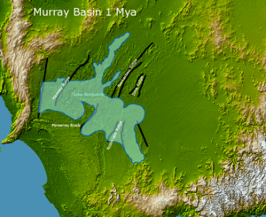
About 2.5 million years ago, the Murray River was blocked by land uplift in the Grampians in Victoria. This created a giant freshwater lake called Lake Bungunnia. It was huge, covering about 40,000 square kilometres (15,000 square miles)!
At first, heavy rainfall kept the lake full. But later, there wasn't enough rain, and the lake became salty, forming dolomite. Even today, some salty lakes remain from this time. The Murray River eventually carved a new path to the sea near Murray Bridge, South Australia. Lake Bungunnia disappeared about 0.7 million years ago.
Modern Surface and Deposits
Most of the land surface we see today in the Murray Basin formed in the last 2.5 million years. Rivers flowing from the east have continuously added new layers of sediment over the older marine deposits.
During periods of higher rainfall (warmer times between ice ages), three layers of sand were deposited. These sand layers now hold water underground and are called aquifers. The current river deposits are known as the Coonambidgal Formation. During drier, colder ice ages, the area was very dry.
34°11′20″S 142°09′30″E / 34.18889°S 142.15833°E
 | Calvin Brent |
 | Walter T. Bailey |
 | Martha Cassell Thompson |
 | Alberta Jeannette Cassell |


