
Muzaffarpur district facts for kids
Quick facts for kids
Muzaffarpur district
|
|
|---|---|
|
District of Bihar
|
|

Location of Muzaffarpur district in Bihar
|
|
| Country | India |
| State | Bihar |
| Division | Tirhut |
| Headquarters | Muzaffarpur |
| Area | |
| • Total | 3,173 km2 (1,225 sq mi) |
| Population
(2011)
|
|
| • Total | 4,801,062 |
| • Density | 1,513.10/km2 (3,918.9/sq mi) |
| Demographics | |
| • Literacy | 65% |
| • Sex ratio | 900 |
| Time zone | UTC+05:30 (IST) |
| Major highways | NH 57, NH 28, NH 77, NH 102, NH 527C |
| Website | http://muzaffarpur.bih.nic.in/ |
Muzaffarpur District is an important area in the Bihar state of India. It is one of the many districts that make up Bihar. This district is part of the Tirhut Division, which is a larger administrative area. The main city and headquarters of the district is Muzaffarpur.
The district is known for its many rivers. These include the Gandak, Budhi Gandak, Bagmati, and Lakhandei. These rivers are very important for the local environment and farming.
Contents
About Muzaffarpur District
Muzaffarpur District is located in the northern part of Bihar, India. It is a place with a rich history and a lively culture. The district is named after its main city, Muzaffarpur.
Location and Size
Muzaffarpur District covers an area of about 3,173 square kilometers. This makes it a medium-sized district in Bihar. It is an important center for trade and farming in the region.
Population and People
According to the 2011 census, about 4.8 million people live in Muzaffarpur District. This means it is a very populated area. Most people live in rural areas, but the city of Muzaffarpur is quite busy.
The district has a literacy rate of about 65%. This means that 65 out of every 100 people can read and write. The sex ratio is 900, meaning there are 900 females for every 1000 males.
Government and Administration
Muzaffarpur District is governed by local and state officials. These officials help manage the district's services and development. The district is divided into smaller parts called Tehsils for easier administration.
Political Representation
People in Muzaffarpur District vote for their representatives in the government. They elect members to two important bodies:
- The Lok Sabha: This is the lower house of the Indian Parliament. Muzaffarpur District is part of the Muzaffarpur and Vaishali Lok Sabha constituencies.
- The Vidhan Sabha: This is the state legislative assembly of Bihar. The district has several Vidhan Sabha constituencies, including Gaighat, Aurai, and Muzaffarpur.
Geography and Rivers
The landscape of Muzaffarpur District is mostly flat. It is part of the fertile Gangetic plains. This makes the land very good for farming.
Major Rivers
Several rivers flow through Muzaffarpur District. These rivers are vital for irrigation and local life.
- The Gandak River is one of the main rivers.
- The Budhi Gandak River also flows through the district.
- Other important rivers include the Bagmati River and the Lakhandei River.
These rivers help keep the soil rich and support agriculture.
Economy and Agriculture
The economy of Muzaffarpur District mainly relies on agriculture. Farmers grow many different crops here.
Famous Lychees
Muzaffarpur is especially famous for its delicious Shahi Lychees. These sweet fruits are grown in large gardens across the district. They are even exported to other parts of India and the world. The lychee season is a very important time for the local economy.
Transportation and Roads
The district has a good network of roads that connect it to other parts of Bihar and India. Major highways pass through Muzaffarpur, helping with trade and travel. These include:
- NH 57
- NH 28, NH 77, NH 102, NH 527C
These highways make it easier for goods to be transported and for people to move around.
Images for kids
-
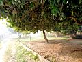
Lychee garden in Muzaffarpur

See also
 In Spanish: Distrito de Muzaffarpur para niños
