Mynydd Cambergi facts for kids
Quick facts for kids Mynydd Cambergi |
|
|---|---|

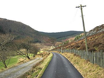
Looking west along Cwm Hengae, with the lower slopes of Mynydd Cambergi on the right
|
|
| Highest point | |
| Elevation | 449 m (1,473 ft) |
| Naming | |
| Language of name | Welsh |
| Geography | |
| Location | Gwynedd, UK |
| Parent range | Snowdonia |
| OS grid | SH 767111 |
Mynydd Cambergi is a cool mountain in Snowdonia, a beautiful national park in Wales. It's also sometimes called Mynydd Cam-bergi. This mountain is part of a long line of hills. It sits between two other peaks, Mynydd y Waun to the north and Foel Grochan to the east. Mynydd Cambergi makes up the north-east side of a valley called Cwm Hengae. It's only about 0.8 kilometers (half a mile) west of a small village named Aberangell.
What is Mynydd Cambergi?
Mynydd Cambergi is a mountain located in the southern part of Snowdonia. It stands 449 meters (about 1,473 feet) tall. This makes it a noticeable feature in the landscape. The mountain is found in Gwynedd, a county in the UK country of Wales.
It's part of the stunning Snowdonia mountain range. The name "Mynydd Cambergi" comes from the Welsh language. This area is known for its rugged beauty and rich history.
A Look at Cambergi Quarry
Near the top of Mynydd Cambergi, you can find an old open pit. This pit is what remains of the Cambergi quarry. A quarry is a place where stone or other materials are dug out of the ground.
This quarry was active for a short time. People worked there from the 1870s until the 1890s. They likely extracted slate or other valuable rock from the mountain. Today, it's a quiet reminder of the area's industrial past.
 | Audre Lorde |
 | John Berry Meachum |
 | Ferdinand Lee Barnett |

