Mystic Island, New Jersey facts for kids
Quick facts for kids
Mystic Island, New Jersey
|
|
|---|---|
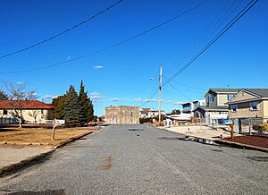
Abandoned Tuckerton Wireless Tower anchor along Ensign Drive
|
|
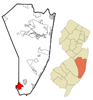
Location of Mystic Island in Ocean County highlighted in red (left). Inset map: Location of Ocean County in New Jersey highlighted in orange (right).
|
|
| Country | |
| State | |
| County | Ocean |
| Township | Little Egg Harbor |
| Area | |
| • Total | 7.71 sq mi (19.96 km2) |
| • Land | 6.92 sq mi (17.93 km2) |
| • Water | 0.78 sq mi (2.03 km2) 10.08% |
| Elevation | 3 ft (1 m) |
| Population
(2020)
|
|
| • Total | 8,301 |
| • Density | 1,199.4/sq mi (463.1/km2) |
| Time zone | UTC−05:00 (Eastern (EST)) |
| • Summer (DST) | UTC−04:00 (Eastern (EDT)) |
| FIPS code | 34-49560 |
| GNIS feature ID | 02389525 |
Mystic Island is a community in New Jersey, also known as Mystic Islands or just Mystic. It's a special kind of community called a census-designated place (CDP). This means it's an area grouped together for census information.
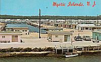
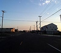
Mystic Island is located in Little Egg Harbor Township, which is part of Ocean County. In 2020, about 8,301 people lived there. It's a large area with many homes right on the water. It was first planned as a vacation spot in the early 1960s, with small bungalows. Today, many of these older bungalows are being replaced by bigger homes built on tall supports, like those found in nearby beach towns.
Contents
Mystic Island's Early History
The area we now call Mystic Island was once known as "Hickory Island." It was connected by the Tuckerton Railroad and a two-lane road. This road was first called "Shore Road." Later, its name changed to "Radio Road" because of a very tall tower built nearby.
The Tuckerton Wireless Tower
The Tuckerton Wireless Tower was built in 1912 by a German company. It was used to send radio messages across the Atlantic Ocean to a similar station in Germany. This communication started just before World War I began in 1914.
The tower was very important for sending messages. When America joined World War I in 1917, the U.S. Navy took over the station. They used it to back up their main radio station. After the war, the station was sold to RCA, a big radio company. RCA used it until 1948.
The tower itself was 680 feet tall and held up by three large concrete blocks. On December 27, 1955, the tower was taken down. You can still see the three huge anchor blocks today. They are in people's backyards and in the middle of some streets. Smaller anchor blocks are also visible in the lagoons.
How Mystic Island Was Developed
After the tower was removed, RCA sold the land to a company called Lagoon Parks, Inc. This company started developing the area in 1959. They named it "Mystic Islands" because they created seven small islands by filling in waterways.
The company dug out the lagoons until the early 1970s. This work stopped when the New Jersey Department of Environmental Protection created new rules to protect the environment. You can still see some unfinished lagoons today. The original "Mystic Islands" only included areas south of Calabreeze Way. However, locals often include nearby neighborhoods as part of the community.
The first parts of Mystic Island to be finished were near Radio Road. The Twin Lakes Boulevard section was built later, into the 1970s. The island now called "Osborn Island" was originally named "Oceanview." It could only be reached by a bridge on Radio Road.
For many years, homes had a confusing lot-and-block numbering system. This was later changed to easier house numbers. Old wooden street signs were replaced with modern ones. Some of the original tower bases were never removed. People even built roundabouts around two of them!
Home Designs in Mystic Island
The first homes built in Mystic Island were simple bungalows. They usually had two or three bedrooms, one bathroom, and a carport. These homes were designed for both vacations and year-round living. They even came with a furnace and good insulation.
Over time, many different home styles were added. Buyers could choose from a catalog of designs. The homes were built in a warehouse nearby and delivered about a week after being ordered. Model homes were located on Radio Road.
Mystic Island's Geography
Mystic Island covers about 7.7 square miles (19.9 square kilometers). Most of this area, about 6.9 square miles (17.9 square kilometers), is land. The rest, about 0.77 square miles (2.0 square kilometers), is water. About 10% of Mystic Island's total area is water.
Mystic Island's Population
| Historical population | |||
|---|---|---|---|
| Census | Pop. | %± | |
| 1980 | 4,929 | — | |
| 1990 | 7,400 | 50.1% | |
| 2000 | 8,694 | 17.5% | |
| 2010 | 8,493 | −2.3% | |
| 2020 | 8,301 | −2.3% | |
| Population sources: 1980 1990-2010 2000 2010 2020 |
|||
Population in 2010
In 2010, there were 8,493 people living in Mystic Island. There were 3,490 households, and 2,331 families. Most of the people, about 95%, were White. About 5% of the population was Hispanic or Latino.
About 23% of households had children under 18. More than half, about 52%, were married couples living together. The average household had 2.39 people. The average family had 2.89 people.
About 19% of the population was under 18 years old. About 22.5% were 65 years or older. The average age in Mystic Island was 47.2 years.
Recreation in Mystic Island
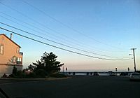
When Mystic Island was first growing, it had several places for fun. In the Oceanview area, there was a small golf course, a beach, and a small amusement park. The golf course is now a protected forest, and the amusement park is gone.
However, the beach was rebuilt and is now called "Graveling Point." You can still visit it today. There was also a round building called a "Boatel." This was a place where boaters could dock, eat, and even sleep. It later became a pizza place and then a bar. Today, it is a church.
Another building, "The Playhouse," was originally a welcome center. It had gift shops, a large swimming pool, and a marina. This building later became a restaurant called the "Mystic Island Casino." The original building burned down, but a new "Mystic Island Casino" opened in a different location and is still open today. The original site is now home to apartments.
The building that is now the Little Egg Harbor Community Center was once a shop. It was used for building the prefabricated homes. Later, it became a Roman Catholic church. In 2002, the township bought the building, and it is now used as the community center for everyone.
See also
 In Spanish: Mystic Island (Nueva Jersey) para niños


