
Naama Province facts for kids
Quick facts for kids
Naâma Province
ولاية النعامة
|
|
|---|---|

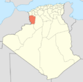
Map of Algeria highlighting Naâma
|
|
| Country | |
| Capital | Naâma |
| Area | |
| • Total | 29,950 km2 (11,560 sq mi) |
| Population
(2008)
|
|
| • Total | 209,470 |
| • Density | 6.9940/km2 (18.114/sq mi) |
| Time zone | UTC+01 (CET) |
| Area Code | +213 (0) 49 |
| ISO 3166 code | DZ-45 |
| Districts | 7 |
| Municipalities | 12 |
Naâma is a province in Algeria, a country in North Africa. A province is like a large region or state within a country. The main city and capital of Naâma Province is a town also called Naâma.
This province is located in the western part of Algeria. It covers a large area of about 29,950 square kilometers (11,564 square miles). That's bigger than some small countries! In 2008, about 209,470 people lived in Naâma Province.
Contents
Exploring Naâma Province
Naâma Province is divided into smaller areas to help manage it. These areas are called districts and municipalities.
Districts and Municipalities
The province has 7 main districts. Each district then contains several smaller areas called communes or municipalities. In total, there are 12 municipalities across the province.
Here are the 7 districts:
- Aïn Séfra
- Asla
- Mécheria
- Mekmen Ben Amar
- Moghrar
- Naâma
- Sfissifa
Transportation
One important place in the province is Mécheria. This town has an airport. Airports are important for travel and connecting people and goods to other parts of Algeria and the world.
Images for kids
-
Map of Algeria highlighting Naâma Province
See also
 In Spanish: Provincia de Naama para niños
