Naguanagua Municipality facts for kids
Quick facts for kids
Naguanagua Municipality
Municipio Naguanagua
|
|||
|---|---|---|---|
|
Municipality
|
|||
|
|||

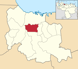
Location in Carabobo
|
|||
| Lua error in Module:Location_map at line 416: Malformed coordinates value. | |||
| Country | |||
| State | Carabobo | ||
| Founded | May 14, 1782 | ||
| Municipal seat | Naguanagua | ||
| Area | |||
| • Total | 168.2 km2 (64.9 sq mi) | ||
| Elevation | 497 m (1,631 ft) | ||
| Population
(2011)
|
|||
| • Total | 157,437 | ||
| • Density | 936.01/km2 (2,424.3/sq mi) | ||
| Time zone | UTC−4 (VET) | ||
| Area code(s) | 0241 | ||
Naguanagua is a municipality in the Carabobo state of Venezuela. It is one of the 14 municipalities in the state. In 2011, about 157,437 people lived here.
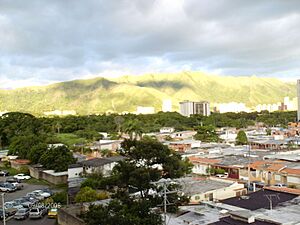
The town of Naguanagua is the main town of the Naguanagua Municipality. It is part of the larger Valencia Metropolitan Area. The municipality is located in the valley of the Cabriales River. It sits at the base of two mountains, Cerro El Café and El Trigal Mountain. Valencia and Naguanagua are connected and form one big urban area. A main highway from Valencia to Puerto Cabello goes through Naguanagua.
Contents
People and Population
In 2007, about 143,315 people lived in Naguanagua. This number was higher than in 2000, when it was 134,728. This means that about 6.4% of all the people in Carabobo state live in Naguanagua. The municipality has about 762 people living in each square kilometer.
History of Naguanagua
Before the Spanish arrived in 1547, the Arawak people lived in this area. The name Naguanagua comes from the name of a local chief, Nagoanagoa. He ruled the settlement and the land around it.
In 1553, a special land grant was given to Pedro Álvarez, who was the Mayor of Borburata. Naguanagua became its own parish on May 14, 1782. This was made official by the Bishop of Caracas, Don Mariano Martí.
Fun Places to Visit
In downtown Naguanagua, you can find the Parochial Church of Naguanagua. There is also the Parochial House and Bolívar Square. Near the Carabobo Hospital, you can find the Spaniards Road (Camino de Los Españoles). This is an old colonial path in the San Esteban National Park. You can follow it down to San Esteban town, which is close to Puerto Cabello.
You can also visit La Entrada, a village near Naguanagua. Here, you will find the Atanasio Girardot Monument.
Sports and Shopping
Naguanagua has many sports areas. These include the "Don Bosco Field" downtown. There is also the "Simón Bolívar Bicentennial Sport Complex" in La Granja. Other places are the "Patinodrome of Capremco" and the "University City Sport Complex."
The municipality also has the biggest shopping centers in Carabobo State. These include Sambil Centre in Ciudad Jardín Mañongo. You can also visit La Granja Shopping Centre and Cristal Naguanagua Centre. Vía Veneto Shopping Center is another popular spot.
Parks and Other Attractions
Other interesting places include the offices of El Carabobeño newspaper. You can find them on University Avenue. There is also Los Guayabitos Park and the Botanical Garden of Naguanagua.
Paseo La Granja Park and Liberty Park (also called Peace Park) are great for relaxing. For fun, you can visit the "Dunas" Park of Attractions. It is near the first World Trade Centre of Venezuela. Another fun spot is "Ditto Park" in Tazajal.
Universities and Learning
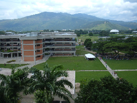
Naguanagua is home to the main campus of the University of Carabobo (Universidad de Carabobo (UC)). This campus is very large. It works like its own community with its own security and transportation.
Other universities in Naguanagua include:
- University College of Administration and Trade (CUAM)
- National "Open" University (UNA)
- National Polytechnic Research University of the Armed Forces (UNEFA)
- Bicentennial University of Aragua (UBA)
Getting Around Naguanagua
Roads for Travel
You can travel around the city using the Centre Regional Highway (Autopista Regional del Centro (ARC)). There are also major roads like University Avenue. Other important avenues include Salvador Feo La Cruz Avenue and Valencia Avenue.
Train Connections
The old train line, the Puerto Cabello and Valencia Railway, closed in the 1950s. Now, a new railway is being built from Puerto Cabello to La Encrucijada. One of the train stations will be in Naguanagua municipality. This station will connect the national train system with the Valencia Metro.
In 2016, work on the Puerto Cabello railway was slow. This was because of Venezuela's economic problems, especially due to lower oil prices.
Neighborhoods
Naguanagua has many neighborhoods, including:
- Agua Linda
- Barrio Unión
- Ciudad Jardín Mañongo
- El Naranjal
- La Granja
- Las Quintas
- Mañongo
- Palma Real
- Tazajal
See also
 In Spanish: Municipio Naguanagua para niños
 | Aaron Henry |
 | T. R. M. Howard |
 | Jesse Jackson |


