
Nakhon Nayok province facts for kids
Quick facts for kids
Nakhon Nayok
นครนายก
|
|||
|---|---|---|---|
     (clockwise from upper-left): Wat Udom Thani, Luang Pho Pak Daeng Buddha at Wat Phrammani, Bamboo Forest of Wat Chulaphonwanaram, Buddharupa Shrine of Srinakharinwirot University’s Ongkharak Campus, Khun Dan Prakan Chon Dam
|
|||
|
|||
| Motto(s):
Nakhon Nayok, city of dream just by the capital, beautiful mountains, gorgeous falls, rich in nature, pollution-free
|
|||

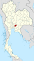
Map of Thailand highlighting Nakhon Nayok province
|
|||
| Country | Thailand | ||
| Capital | Nakhon Nayok City | ||
| Area | |||
| • Total | 2,122 km2 (819 sq mi) | ||
| Area rank | Ranked 67th | ||
| Population | |||
| • Total | 260,093 | ||
| • Rank | Ranked 73rd | ||
| • Density | 123/km2 (320/sq mi) | ||
| • Density rank | Ranked 39th | ||
| Human Achievement Index | |||
| • HAI (2017) | 0.5886 "average" Ranked 36th |
||
| Time zone | UTC+7 (ICT) | ||
| Postal code |
26xxx
|
||
| Calling code | 037 | ||
| ISO 3166 code | TH-26 | ||


Nakhon Nayok is a province in central Thailand. It was officially created on May 9, 1946.
This province is surrounded by other provinces. To the north, it borders Saraburi province. To the east, you'll find Nakhon Ratchasima province and Prachinburi province. To the south, it's next to Chachoengsao province, and to the west, it borders Pathum Thani province.
Nakhon Nayok is famous for its beautiful waterfalls and many different kinds of fruit. It's also quite close to Bangkok, making it an easy place to visit. You can explore Khao Yai National Park, which is Thailand's oldest national park and partly located here. Another popular spot is the Khun Dan Prakan Chon Dam.
Contents
What's in the Name?
The name Nakhon Nayok has an interesting meaning. The word nakhon comes from an old Sanskrit word, nagara, which means 'city'.
The word nayok is believed to come from nāyaka, meaning 'leader'. However, in this case, na means 'rice field tax' and yok means 'exempted'. So, the name of the province literally means 'tax-free city'.
A Look at History
The city of Nakhon Nayok has a long history, going back to the Dvaravati Kingdom around the 11th century. You can still see old ruins from this time at Mueang Boran Dong Lakhon, south of the modern city.
In 1350, the city was named "Nakhon Nayok". It became an important military town for the Ayutthaya kingdom, helping to protect its eastern borders. For a short time, from 1943 to 1946, Nakhon Nayok province was combined with other provinces. But on May 9, 1946, it became a separate province again.
Symbols of the Province
Every province in Thailand has special symbols.
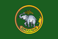
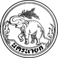
- Provincial Seal: The seal of Nakhon Nayok shows an elephant holding an ear of rice with its trunk. This symbol represents the province's fertile rice fields and its forests, which are home to many elephants. In the background, you can see piles of straw, trees, and clouds, showing the natural beauty of the area.
- Provincial Tree and Flower: The official tree and flower of Nakhon Nayok is the silk cotton tree (Cochlospermum religiosum).
Weather in Nakhon Nayok
Nakhon Nayok has a tropical savanna climate. This means it has dry, warm winters. Temperatures usually get hotter until May.
The monsoon season, which brings heavy rain, lasts from May to October. During this time, the days are a bit cooler, but the nights stay warm.
Nature and Geography

The northern part of Nakhon Nayok province is covered by the Sankamphaeng Range, which is a mountain range. The highest point here is Yod Khao Kiew, which is 1,292 meters tall. Most of this area is part of the Khao Yai National Park, a very large protected area.
The middle part of the province is a flat plain formed by the Nakhon Nayok River. The southern part of the province has soil that is not very fertile. About 30 percent of the province is covered by forests.
The main river in the province is the Nakhon Nayok River. It eventually joins another river to become the Bang Pa Kong River.
How the Province is Governed

Nakhon Nayok province is divided into four main areas called districts (amphoes). These districts are further split into smaller areas called subdistricts (tambons) and villages (mubans).
The four districts are:
- Mueang Nakhon Nayok
- Pak Phli
- Ban Na
- Ongkharak
The province has a local government that includes one Provincial Administration Organisation and six municipal areas. Nakhon Nayok City is a town municipality. There are also five subdistrict municipalities. Other areas are managed by Subdistrict Administrative Organisations.
Images for kids
-
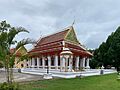
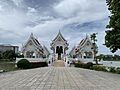
Wat Udom Thani
-
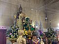
Luang Pho Pak Daeng Buddha at Wat Phrammani
-
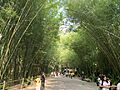
Bamboo Forest of Wat Chulaphonwanaram
-
Buddharupa Shrine of Srinakharinwirot University’s Ongkharak Campus
-

Khun Dan Prakan Chon Dam
-
Flag of Nakhon Nayok
-
Seal of Nakhon Nayok
-
Map of Thailand highlighting Nakhon Nayok province
See also
 In Spanish: Provincia de Nakhon Nayok para niños
