Nash Harbor, Alaska facts for kids
Quick facts for kids
Nash Harbor, Alaska
|
|
|---|---|

|
|
| Country | United States |
| State | Alaska |
| Census Area | Bethel |
| Elevation | 0 ft (0 m) |
| Time zone | UTC-9 (Alaska (AKST)) |
| • Summer (DST) | UTC-8 (AKDT) |
| Area code(s) | 907 |
| GNIS feature ID | 1406850 |
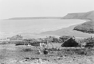
Nash Harbor is a small, unincorporated community located on Nunivak Island in Alaska, United States. An unincorporated community means it's a settlement without its own local government. It's found on the western side of a bay that shares its name, on the northern coast of the island.
Nash Harbor is about 35 miles (56 kilometers) west of Mekoryuk. Mekoryuk is the main town on Nunivak Island. Nash Harbor was originally a settlement of the Yupik people, who are native Alaskans. In 1950, the community had a population of 49 people. Today, the Ellikarrmiut Summer Science Field Camp is held here. This camp is a college-level biology program.
Population History
| Historical population | |||
|---|---|---|---|
| Census | Pop. | %± | |
| 1950 | 49 | — | |
| U.S. Decennial Census | |||
Nash Harbor appeared only once in the official U.S. Census records. This was in 1950, when it was counted as an unincorporated village. Since then, it has not been listed in the census. This often happens when a community becomes very small or is no longer officially recognized as a separate settlement.


