Nunivak Island facts for kids
|
Nunivak Island (Alaska)
|
|
| Geography | |
|---|---|
| Location | Bering Sea |
| Coordinates | 60°05′42″N 166°12′40″W / 60.09500°N 166.21111°W |
| Area | 1,631.97 sq mi (4,226.8 km2) |
| Length | 77 km (47.8 mi) |
| Width | 106 km (65.9 mi) |
| Highest elevation | 1,675 ft (510.5 m) |
| Highest point | Roberts Mountain |
| Administration | |
|
United States
|
|
| State | Alaska |
| Census Area | Bethel Census Area |
| Largest settlement | Mekoryuk (pop. 191) |
| Demographics | |
| Population | 191 (2010) |
| Pop. density | 0.05 /km2 (0.13 /sq mi) |
| Ethnic groups | Cup'it Eskimo |
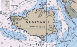
Nunivak Island is a cool, volcanic island in Alaska, USA. It's covered in permafrost, which means the ground is always frozen. The island is about 30 miles (48 km) off the coast from the Yukon and Kuskokwim rivers.
Nunivak Island is very large. It covers about 1,631.97 square miles (4,226.8 km2). This makes it the second-largest island in the Bering Sea. It's also the eighth-largest island in the entire United States. The island is 76.2 kilometers (47.3 mi) long and 106 kilometers (66 mi) wide. In 2010, about 191 people lived there. All of them live in the town of Mekoryuk on the north coast.
Contents
Life on Nunivak Island
Nunivak Island has only one town where people live all the time. This town is called Mekoryuk. It's located on the north side of the island. Today, about 200 people call Mekoryuk home.
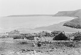
A long time ago, in 1880, there were about 702 people living in nine different villages on the island. However, a sickness in 1900 greatly reduced the number of people. Also, some people moved away, which kept the population small.
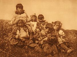
Many famous people have visited Nunivak. These include the journalist Jon Lee Anderson and the photographer Edward S. Curtis. The artist Muriel Hannah also explored the island. In 2015, conservationist Steven Rinella filmed an episode of his TV show Meat Eater there. He learned about muskox hunting and the island's culture.
The Cup'it People and Their Culture
Most people living on Nunivak Island are Cup'it Eskimo. Their traditional language is called Cup'ig. It's a special dialect of Central Alaskan Yup'ik. For many older islanders, Cup'ig is their first language. Younger people are also working hard to learn and use it again. Almost everyone on Nunivak Island, or Nuniwarmiut as they call themselves, also speaks English.
The people of Nunivak Island still get a lot of their food by subsistence hunting. This means they hunt animals like reindeer and musk ox for their families. They also work in commercial fishing or in industries on the mainland.
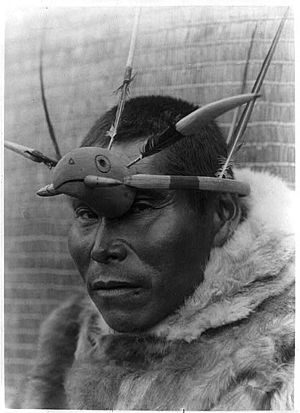
The art of Nunivak Island has a very old history. Some sculptures are thousands of years old. In the past, people made masks to trade for things they needed. Later, masks were used for celebrations, dances, and traditional healing.
One type of mask shows the animals important to Nunivak Island life. For example, the walrus and the loon are very important. People depended on these animals for food and other supplies. Walrus skin was used to make kayaks waterproof. It was also used for the soles of mukluks (Cup'ig boots). Walrus intestines were even used to make waterproof rain gear! Bones were used for tools, and ivory for spearheads and carvings. Loon pelts were made into warm, waterproof winter coats.
Nunivak's Landscape and Wildlife
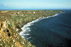
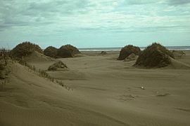
Nunivak Island was formed by volcanoes. Most of the island is a high, flat area called a volcanic plateau, which is about 500 feet (160 meters) above sea level. The island has about 60 small volcanic hills called cinder cones. It also has four maars, which are wide, flat volcanic craters.
Most of the island's surface is made of thin layers of lava from small shield volcanoes. These volcanoes erupted over millions of years. The last big eruptions happened about 300,000 years ago. Because of all this volcanic activity, Nunivak Island is part of the Bering Sea Volcanic Province.
The main type of landscape on Nunivak Island is tundra. The biggest trees you'll find are dwarf willow trees, which are usually less than 4 feet (1.2 meters) tall. More than 40 rivers flow across the tundra. Along the eastern and southern coasts, there are salty lagoons. The northwest coast has steep volcanic cliffs.
Animals of Nunivak Island
Nunivak Island is a temporary home for at least 89 types of migratory seabirds and waterfowl. Many of these birds are endangered or threatened. In the summer, large groups of birds nest on the island's shores and in its inland lakes.
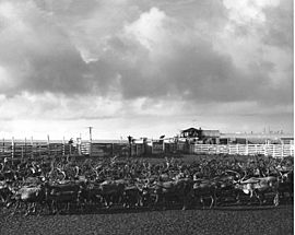
Long ago, Nunivak Island had a small herd of caribou. But these animals disappeared after people started using firearms. In the 1930s and 1940s, the United States Fish and Wildlife Service brought reindeer and musk ox back to the island. Today, large herds of these animals are cared for by the local Native Corporation of Mekoryuk.
Most of Nunivak Island is part of the Yukon Delta National Wildlife Refuge. This refuge helps protect the island's unique environment and wildlife.
Demographics
| Historical population | |||
|---|---|---|---|
| Census | Pop. | %± | |
| 1880 | 400 | — | |
| 1910 | 127 | — | |
| 1920 | 189 | 48.8% | |
| 1930 | 191 | 1.1% | |
| 1940 | 225 | 17.8% | |
| U.S. Decennial Census | |||
Nunivak Island was first counted in the 1880 U.S. Census. At that time, 400 Yupik people lived there. In 1890, the different villages on the island were counted separately. From 1910 to 1940, the whole island was counted together again. Since 1950, any towns on the island have been counted separately. As of 2000 and 2010, all residents live in Mekoryuk.
See also
 In Spanish: Isla Nunivak para niños
 | Selma Burke |
 | Pauline Powell Burns |
 | Frederick J. Brown |
 | Robert Blackburn |


