
Kuskokwim River facts for kids
Quick facts for kids Kuskokwim River |
|
|---|---|

Aerial photograph of the river
|
|

Watershed of the Kuskokwim River in Alaska
|
|
| Native name | Kusquqvak / Dichinanek' |
| Country | United States |
| State | Alaska |
| Districts | |
| Physical characteristics | |
| Main source | confluence of the river's east and north forks near Medfra, Yukon–Koyukuk Census Area 3,655 ft (1,114 m) 63°05′16″N 154°38′33″W / 63.08778°N 154.64250°W |
| River mouth | Kuskokwim Bay near Eek, Bethel Census Area 0 ft (0 m) 60°04′59″N 162°20′02″W / 60.08306°N 162.33389°W |
| Length | 702 mi (1,130 km) |
| Basin features | |
| Basin size | 48,000 sq mi (120,000 km2) |
The Kuskokwim River is a very long river in Alaska, United States. It's about 702 miles (1,130 km) long! It's one of the biggest rivers in the U.S. when you look at how much water flows out of it. The river's name, Kuskokwim, comes from the Yup'ik language and means "big slow moving thing."
This river is super important because it drains a huge area of Alaska's interior. It flows southwest into Kuskokwim Bay, which is part of the Bering Sea. The Kuskokwim River is mostly wide and flat, making it easy for boats to travel on it. In winter, when it freezes, people even use it as an ice road for vehicles! It's also the longest river in the United States that flows freely, meaning it doesn't have any dams blocking its path.
Contents
About the Name
The name Kuskokwim comes from the Yup'ik language. A Russian sailor first wrote down this name in 1826. The word kusquqviim means "big slow moving thing."
Different groups of Alaska Natives live along the river.
- The Yup'ik Eskimo people live along the lower part of the river.
- The Deg Hit'an Athabaskan people live along the middle part.
- The Upper Kuskokwim Athabaskan people live along the upper part.
- The Koyukon Athabaskan people live near the North Fork and Lake Minchumina.
River's Journey
The Kuskokwim River starts where two smaller rivers meet. These are the East Fork Kuskokwim River and the North Fork Kuskokwim River. This meeting point is about 5 miles (8 km) east of Medfra. From there, the main river flows southwest all the way to Kuskokwim Bay and the Bering Sea.
Where the Forks Begin
The North Fork of the Kuskokwim is about 250 miles (400 km) long. It starts in the Kuskokwim Mountains and flows southwest through a wide valley.
The South Fork is about 200 miles (320 km) long. It begins in the southwestern part of the Alaska Range. It flows north-northwest through the mountains, passing by Nikolai. Many other streams from the Alaska Range also join it.
Flowing to the Sea
After the forks join near Medfra, the main Kuskokwim River flows southwest. It passes by McGrath in a quiet valley. This valley is between the Kuskokwim Mountains to the north and the Alaska Range to the south.
As the river reaches southwest Alaska, it leaves the mountains. It enters a huge, flat area with many lakes and spruce forests. Here, it flows past several Yup'ik villages, including Aniak. The river gets very close to the Yukon River before turning southwest again.
Southwest of Bethel, which is the biggest town on the river, the Kuskokwim spreads out into a wide, marshy delta. This delta then flows into Kuskokwim Bay. The lower part of the river, below Aniak, is part of the Yukon Delta National Wildlife Refuge. This refuge is a protected area for wildlife.
Rivers Joining the Kuskokwim
Many other rivers flow into the Kuskokwim.
- The Big River joins from the south, about 20 miles (32 km) southwest of Medfra.
- The Swift, Stony, and Holitna rivers join from the south. This happens where the Kuskokwim Mountains end.
- The Aniak River joins from the south at Aniak.
- About 20 miles (32 km) upstream from Bethel, the Kisaralik and Kwethluk rivers join from the south.
- The Eek River joins from the east at Eek, close to where the Kuskokwim meets Kuskokwim Bay.
River History and Use
For a long time, people living along the Kuskokwim River have relied on it for their lives. They have historically been involved in fur trapping and fishing. Fishing for salmon and whitefish is a very important part of the Yup'ik people's diet.
In 1901, people found placer gold near Aniak. This means gold that was found in loose sand or gravel. The region has produced a lot of gold over the years. The famous Iditarod Trail, a long dog sled race route, follows the South Fork Kuskokwim River and crosses the main river near McGrath.
Images for kids
-
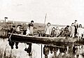
Yup'ik at Moravian Mission Station at Kuskokwim River in the year 1900

See also
 In Spanish: Río Kuskokwim para niños
