McGrath, Alaska facts for kids
Quick facts for kids
McGrath
Tochak’, Digenegh
|
|
|---|---|

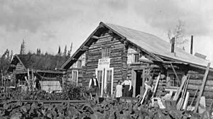
McGrath Post Office, September 1914
|
|
| Country | United States |
| State | Alaska |
| Census Area | Yukon-Koyukuk |
| Incorporated | June 3, 1975 |
| Area | |
| • Total | 47.94 sq mi (124.17 km2) |
| • Land | 42.33 sq mi (109.64 km2) |
| • Water | 5.61 sq mi (14.53 km2) |
| Elevation | 331 ft (101 m) |
| Population
(2020)
|
|
| • Total | 301 |
| • Density | 7.11/sq mi (2.75/km2) |
| Time zone | UTC−9 (Alaska (AKST)) |
| • Summer (DST) | UTC−8 (AKDT) |
| ZIP code |
99627
|
| Area code | 907 |
| FIPS code | 02-46010 |
| GNIS feature ID | 1406131, 2419425 |
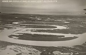
McGrath is a small city and village located in Alaska, United States. It sits right on the Kuskokwim River. In 2020, about 301 people lived there. Even though it's small, McGrath is a key place for travel and business in its region. Its local names are Tochak’ (in Upper Kuskokwim language) and Digenegh (in Deg Xinag language).
Contents
History of McGrath
The original site of McGrath, called Old Town McGrath, was across the river from where the city is today. It was a popular meeting and trading spot for people from nearby villages like Big River, Nikolai, Telida, and Lake Minchumina.
In 1904, a man named Abraham Appel set up a trading post in Old Town. Gold was discovered in the Innoko District in 1906 and at Ganes Creek in 1907. Because McGrath was the farthest point up the Kuskokwim River that large riverboats could reach, it became a main supply center for the area.
A town was officially started at Old McGrath in 1907. It was named after Peter McGrath, who was a local United States Marshal. The famous Iditarod Trail also helped McGrath become an important supply stop. From 1911 to 1920, many people traveled this trail, often with dog sleds, on their way to the gold mining areas near Ophir. However, gold mining slowed down a lot after 1925.
In 1933, a big flood hit the area. Some residents decided to move across the river to a new location. Over time, the river changed its path, leaving the old town on a quiet side channel. This made it no longer useful as a river stop. In 1940, an airstrip was built, and a communications center was added. A school also opened. During World War II, McGrath became an important place to refuel planes and equipment.
Geography and Location
McGrath is located in the middle of Alaska, far from the coast. It is about 221 miles northwest of Anchorage and 269 miles southwest of Fairbanks. The city is situated where the Takotna River meets the south bank of the Kuskokwim River.
The United States Census Bureau says that the city covers a total area of about 47.94 square miles (124.17 square kilometers). Most of this area, about 42.33 square miles (109.64 square kilometers), is land. The rest, about 5.61 square miles (14.53 square kilometers), is water.
Climate in McGrath
McGrath has a continental subarctic climate. This means it has very cold, long winters and short, cool summers.
| Climate data for McGrath Airport, Alaska (1991–2020 normals, extremes 1939–present) | |||||||||||||
|---|---|---|---|---|---|---|---|---|---|---|---|---|---|
| Month | Jan | Feb | Mar | Apr | May | Jun | Jul | Aug | Sep | Oct | Nov | Dec | Year |
| Record high °F (°C) | 54 (12) |
55 (13) |
55 (13) |
68 (20) |
86 (30) |
94 (34) |
90 (32) |
89 (32) |
76 (24) |
67 (19) |
50 (10) |
49 (9) |
94 (34) |
| Mean maximum °F (°C) | 33.2 (0.7) |
40.2 (4.6) |
43.4 (6.3) |
58.3 (14.6) |
75.4 (24.1) |
81.8 (27.7) |
82.6 (28.1) |
77.4 (25.2) |
66.0 (18.9) |
52.7 (11.5) |
35.3 (1.8) |
32.9 (0.5) |
85.3 (29.6) |
| Mean daily maximum °F (°C) | 2.6 (−16.3) |
14.7 (−9.6) |
24.5 (−4.2) |
42.9 (6.1) |
58.9 (14.9) |
68.8 (20.4) |
69.5 (20.8) |
64.0 (17.8) |
53.9 (12.2) |
34.5 (1.4) |
14.9 (−9.5) |
5.5 (−14.7) |
37.9 (3.3) |
| Daily mean °F (°C) | −5.8 (−21.0) |
4.5 (−15.3) |
11.9 (−11.2) |
32.2 (0.1) |
48.4 (9.1) |
58.7 (14.8) |
60.8 (16.0) |
55.9 (13.3) |
46.0 (7.8) |
28.4 (−2.0) |
8.0 (−13.3) |
−2.3 (−19.1) |
28.9 (−1.7) |
| Mean daily minimum °F (°C) | −14.1 (−25.6) |
−5.6 (−20.9) |
−0.7 (−18.2) |
21.5 (−5.8) |
38.0 (3.3) |
48.6 (9.2) |
52.1 (11.2) |
47.8 (8.8) |
38.0 (3.3) |
22.4 (−5.3) |
1.1 (−17.2) |
−10.0 (−23.3) |
19.9 (−6.7) |
| Mean minimum °F (°C) | −46.6 (−43.7) |
−38.7 (−39.3) |
−27.7 (−33.2) |
−4.7 (−20.4) |
23.7 (−4.6) |
36.8 (2.7) |
42.8 (6.0) |
34.1 (1.2) |
22.2 (−5.4) |
0.1 (−17.7) |
−26.4 (−32.4) |
−39.0 (−39.4) |
−49.0 (−45.0) |
| Record low °F (°C) | −75 (−59) |
−64 (−53) |
−51 (−46) |
−40 (−40) |
−2 (−19) |
27 (−3) |
31 (−1) |
25 (−4) |
2 (−17) |
−28 (−33) |
−53 (−47) |
−67 (−55) |
−75 (−59) |
| Average precipitation inches (mm) | 1.15 (29) |
0.87 (22) |
0.68 (17) |
0.74 (19) |
0.91 (23) |
1.66 (42) |
2.50 (64) |
2.91 (74) |
2.53 (64) |
1.46 (37) |
1.43 (36) |
1.21 (31) |
18.05 (458) |
| Average snowfall inches (cm) | 14.7 (37) |
12.7 (32) |
9.2 (23) |
4.4 (11) |
0.6 (1.5) |
0.0 (0.0) |
0.0 (0.0) |
0.0 (0.0) |
1.4 (3.6) |
7.4 (19) |
18.2 (46) |
17.9 (45) |
86.5 (218.1) |
| Average precipitation days (≥ 0.01 inch) | 10.4 | 9.2 | 7.8 | 6.7 | 9.3 | 13.1 | 15.1 | 16.3 | 14.0 | 11.9 | 11.3 | 12.0 | 137.1 |
| Average snowy days (≥ 0.1 inch) | 11.3 | 10.2 | 8.4 | 4.8 | 0.7 | 0.0 | 0.0 | 0.0 | 1.2 | 7.5 | 12.4 | 13.9 | 70.4 |
| Average relative humidity (%) | 72.2 | 68.7 | 64.3 | 62.1 | 59.5 | 63.2 | 69.7 | 75.2 | 74.0 | 77.9 | 76.7 | 74.0 | 69.8 |
| Average dew point °F (°C) | −13.7 (−25.4) |
−9.6 (−23.1) |
0.9 (−17.3) |
15.3 (−9.3) |
30.0 (−1.1) |
41.7 (5.4) |
47.7 (8.7) |
45.5 (7.5) |
35.2 (1.8) |
18.7 (−7.4) |
−0.6 (−18.1) |
−11.6 (−24.2) |
16.6 (−8.5) |
| Source: NOAA | |||||||||||||
Population and People
| Historical population | |||
|---|---|---|---|
| Census | Pop. | %± | |
| 1920 | 90 | — | |
| 1930 | 112 | 24.4% | |
| 1940 | 138 | 23.2% | |
| 1950 | 175 | 26.8% | |
| 1960 | 241 | 37.7% | |
| 1970 | 279 | 15.8% | |
| 1980 | 355 | 27.2% | |
| 1990 | 528 | 48.7% | |
| 2000 | 401 | −24.1% | |
| 2010 | 346 | −13.7% | |
| 2020 | 301 | −13.0% | |
| U.S. Decennial Census | |||
McGrath first appeared in the U.S. Census in 1920 as a small village. It officially became a city in 1975.
Based on the 2000 census, there were 401 people living in McGrath. These people lived in 145 households, with 99 of them being families. The population density was about 8.2 people per square mile.
About 42.64% of the people were White, and 43.89% were Native American. A small number were Asian or from other backgrounds. About 11.97% of the people identified as being from two or more races.
Many households, about 42.8%, had children under 18 living with them. About 45.5% were married couples. The average household had 2.77 people, and the average family had 3.34 people.
The population's age spread showed that 35.9% were under 18 years old. About 5.0% were 65 years or older. The average age in McGrath was 33 years. For every 100 females, there were about 104.6 males.
The average income for a household in McGrath was $43,056 per year. For families, the average income was $44,167. About 9.8% of the population lived below the poverty line. This included 10.8% of those under 18 and 17.4% of those 65 or older.
Education in McGrath
The Iditarod Area School District is in charge of running the McGrath School. This school serves the students in the area.
Media and Radio
KSKO is a radio station in McGrath that plays non-commercial programs. It is part of the NPR network and broadcasts at 89.5 FM. KSKO also sends its signal to other villages. These include Grayling (KGYA), Shageluk (KNKO), Holy Cross (KLOP), Nikolai (KNIB), Sleetmute (KSKP), Crooked Creek (KSKC), and Anvik (KMGS). KSKO celebrated its 40th birthday on July 1, 2021.
See also
 In Spanish: McGrath (Alaska) para niños
 | George Robert Carruthers |
 | Patricia Bath |
 | Jan Ernst Matzeliger |
 | Alexander Miles |


