
National Register of Historic Places listings in Adair County, Missouri facts for kids

This page is about the National Register of Historic Places listings in Adair County, Missouri. It's like a special list of important old buildings, places, and areas in Adair County, Missouri, United States. These places are chosen because they have a lot of history or are very special in some way.
When a place is on this list, it means it's recognized as important for its history, architecture, or what happened there. It helps protect these places so future generations can learn from them. You can even see where many of these places are on a map using their exact location coordinates!
Adair County has 20 different properties and historic districts that are on this special list.
Contents
- What is the National Register of Historic Places?
- Cool Historic Places in Adair County
- Adair County Courthouse
- Bear Creek Baptist Church
- Cabins Historic District
- Grim Building
- Capt. Thomas C. Harris House
- Kirksville Courthouse Square Historic District
- Masonic Temple
- St. Mary's Church
- Orie J. Smith Black and White Stock Farm Historic District
- Thousand Hills State Park Petroglyphs Archeological Site
- Images for kids
What is the National Register of Historic Places?
The National Register of Historic Places is the official list of the United States' historic places worth saving. It's managed by the National Park Service. When a building, site, or area is added to this list, it means it's important to the history of the local area, the state, or even the whole country.
Being on the list encourages people to protect these places. It also means they might get special help or funding to keep them in good condition. It's a way to celebrate and remember the past!
Cool Historic Places in Adair County
Adair County is home to many fascinating places on the National Register. Each one tells a unique story about the area's past.
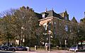
Adair County Courthouse
The Adair County Courthouse is a grand building in Kirksville. It was built a long time ago and is where important county decisions are made. It's a symbol of the community's history and government. It was added to the list in 1978.
Bear Creek Baptist Church
The Bear Creek Baptist Church is a historic church located north of Kirksville. Churches often play a big role in a community's history, and this one is a great example of early religious life in Adair County. It joined the list in 1984.
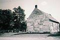
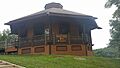
Cabins Historic District
The Cabins Historic District is a special area south of Novinger. A "historic district" means a group of buildings or places that are important together. This district likely shows how people lived or worked in the past, perhaps with old cabins or homes that tell a story. It was listed in 1979.
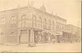
Grim Building
The Grim Building is located on East Washington Street in Kirksville. Many old buildings in town centers were important for businesses or community life. This building, listed in 1979, is a reminder of Kirksville's early commercial days.
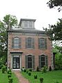
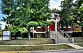
Capt. Thomas C. Harris House
The Capt. Thomas C. Harris House is a historic home in Kirksville. Old houses often show us how people lived, what styles were popular, and who important figures were in the community. This house was added to the list in 1973.
Kirksville Courthouse Square Historic District
Another important district in Kirksville is the Kirksville Courthouse Square Historic District. This area around the courthouse is often the heart of a town. It includes several blocks with historic buildings that show the growth and development of Kirksville over time. It became a historic district in 2009.
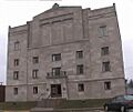
Masonic Temple
The Masonic Temple in Kirksville is known for its unique Egyptian Revival architecture. This style uses elements from ancient Egyptian buildings. It's a cool example of how different architectural styles made their way to Missouri. It was listed in 2010.
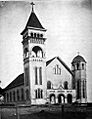
St. Mary's Church
St. Mary's Church is located in the town of Adair. It features Romanesque Revival architecture, which is a style inspired by old Roman buildings. This church, listed in 1974, is a beautiful example of historic religious architecture in the county.
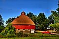
Orie J. Smith Black and White Stock Farm Historic District
The Orie J. Smith Black and White Stock Farm Historic District is a unique historic farm area near Kirksville. Farms are very important to Missouri's history. This district, listed in 2001, helps us understand how farming was done in the past. It even includes a special round barn!
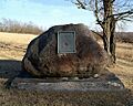
Thousand Hills State Park Petroglyphs Archeological Site
One of the most interesting listings is the Thousand Hills State Park Petroglyphs Archeological Site. Petroglyphs are ancient rock carvings made by early people. This site, located within Thousand Hills State Park, gives us a glimpse into the very distant past of the area. It was listed in 1970.
Images for kids
-
Adair County Courthouse
-
Bear Creek Baptist Church
-
Cabins Historic District
-

Grim Building
-
Capt. Thomas C. Harris House
-
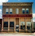
Journal Printing Company Building
-
Kirksville Courthouse Square Historic District
-
Masonic Temple
-
St. Mary's Church
-

Dr. E. Sanborn Smith House
-
Orie J. Smith Black and White Stock Farm Historic District
-
Thousand Hills State Park Petroglyphs Archeological Site
-
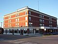
Travelers Hotel
-
Trinity Episcopal Church


