
National Register of Historic Places listings in Arapahoe County, Colorado facts for kids

Arapahoe County in Colorado is home to many special places that are important to history. These places are listed on the National Register of Historic Places. This is like a special list kept by the United States government. It helps protect buildings, sites, and objects that have a big story to tell about our past.
In Arapahoe County, there are 25 different places on this list. They include old homes, schools, farms, and even parts of towns. Each one helps us understand what life was like long ago in Colorado.
What is the National Register of Historic Places?
The National Register of Historic Places is the official list of the nation's historic places worth saving. It is part of a program to coordinate and support public and private efforts to identify, evaluate, and protect America's historic and archaeological resources. When a place is added to this list, it means it is important to the history of the local area, the state, or even the whole country.
Historic Homes and Neighborhoods
Many of the places on the list in Arapahoe County are old homes or entire neighborhoods. These show us how people lived and what their houses looked like in different times.
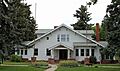
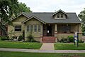
Arapahoe Acres

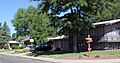
Arapahoe Acres is a special neighborhood in Englewood. It was added to the National Register in 1998. This area is famous for its unique style of houses built in the 1950s. They are known as "Mid-Century Modern" homes. These houses often have flat roofs, large windows, and open spaces inside. They were designed to be modern and comfortable for families after World War II.
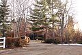
Arapaho Hills

Another interesting neighborhood is Arapaho Hills in Littleton. It joined the list in 2012. Like Arapahoe Acres, it features homes built between 1940 and 1965. These neighborhoods show how cities grew and how people wanted new types of homes during that time.
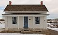
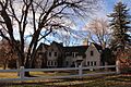
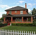
David W. Brown House
The David W. Brown House, located in Englewood, was listed in 1980. This house is an example of older architecture. It helps us see how homes were built before the mid-century modern style became popular.
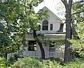
Geneva Home
The Geneva Home in Littleton was added to the list in 1999. It is another example of a historic house that tells a story about the people who lived there and the architectural styles of its time.
Knight-Wood House
The Knight-Wood House, also in Littleton, became a historic place in 2004. Each of these homes has its own unique design and history, making them important parts of the county's heritage.
Important Public Buildings and Sites
Arapahoe County also has historic public buildings and other important sites. These places often served the community in big ways.
Comanche Crossing of the Kansas Pacific Railroad

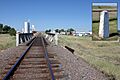
This site near Strasburg was added to the National Register in 1970. It marks a very important spot in railroad history. It's where the Kansas Pacific Railroad completed its tracks across the United States in 1870. This event was a big step in connecting the East and West coasts by train.
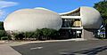
Commandant of Cadets Building, US Air Force Academy

Located in Aurora, this building became historic in 2007. It is part of the United States Air Force Academy. This building has played a role in training future leaders for the Air Force.
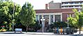
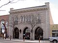
Englewood Post Office

The Englewood Post Office, listed in 2011, is a historic building that once served as a central place for mail and community life. Post offices were often important gathering spots in towns.
Key Savings and Loan Association Building

This building in Englewood was added to the list in 2016. It shows the architectural styles used for banks and financial institutions in the past.
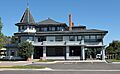
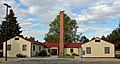
Littleton Town Hall

The Littleton Town Hall, listed in 1980, is a significant building in the heart of Littleton. It served as the center of local government for many years. Today, it is known as the Town Hall Arts Center and hosts plays and other cultural events.
Historic Schools and Farms
Old schools and farms also tell us about how people lived and worked in Arapahoe County.
Curtis School

The Curtis School in Greenwood Village was added to the list in 1992. It is an example of a "rural school building." These schools were often small and served children in farming communities. They were very important for education in less populated areas.
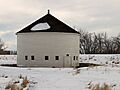
DeLaney Barn and Gully Homestead


The DeLaney Barn (1989) and the Gully Homestead (1986) are both located in Aurora. These sites show us what early farms in Arapahoe County looked like. They remind us of the county's agricultural past, when farming was a major way of life.
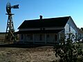
Hopkins Farm

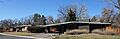
Hopkins Farm in Cherry Hills Village became a historic district in 2007. This farm is another example of the county's farming heritage. It helps us understand how farms were set up and operated long ago.
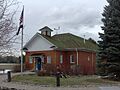
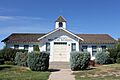
Melvin School

The Melvin School in Aurora was listed in 1984. Like Curtis School, it is part of the "Rural School Buildings in Colorado" group. These schools are important because they show how education developed in rural areas.
Seventeen Mile House

The Seventeen Mile House in Centennial was added to the National Register in 1983. This historic site was once a stop along a stagecoach route. Travelers would stop here to rest, eat, and change horses. It gives us a glimpse into travel and transportation in the old West.
Other Notable Historic Places
Arapahoe County has several other interesting historic properties, many of which are private estates that show the grand homes of the past.
Foster-Buell Estate
The Foster-Buell Estate in Cherry Hills Village was listed in 1998. It represents a large, important property from an earlier time.
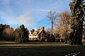
Little Estate

The Little Estate, also in Cherry Hills Village, joined the list in 1998. These estates often have unique architecture and beautiful grounds.
Maitland Estate

The Maitland Estate in Cherry Hills Village was recognized in 1998.
Owen Estate

The Owen Estate, another Cherry Hills Village property, was listed in 1999. These estates provide a look into the lives of prominent families and the styles of their homes.
William Smith House

The William Smith House in Aurora was added to the National Register in 1985. It is another example of a historic home that contributes to the county's rich architectural history.
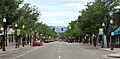
Littleton Main Street Historic District

The Littleton Main Street district was listed in 1998. This area includes many historic buildings along Main Street in Littleton. It shows how the town's business and social center developed over time. Walking down this street is like taking a step back in time to see the shops and buildings from long ago.
Images for kids
-
A home in Arapahoe Acres
-
A house in Arapaho Hills
-
The David W. Brown House
-
The historic Comanche Crossing
-
The Commandant of Cadets Building
-
The historic Curtis School
-
The DeLaney Barn
-
The Englewood Post Office
-
The Geneva Home
-
The Gully Homestead
-
Hopkins Farm
-
The Key Savings and Loan Association Building
-
The Knight-Wood House
-
The Little Estate
-
Littleton Main Street
-
The Littleton Town Hall Arts Center
-
The Maitland Estate
-
The Melvin School
-
The Owen Estate
-
The historic Seventeen Mile House
-
The William Smith House


