
National Register of Historic Places listings in Attala County, Mississippi facts for kids

This article is about the special places in Attala County, Mississippi that are listed on the National Register of Historic Places. These are important buildings, areas, or objects that tell us about the history of the United States. They are officially recognized for their historical, architectural, archaeological, engineering, or cultural importance.
When a place is added to the National Register, it means it's worth saving and protecting for future generations. It helps people understand the past and appreciate the unique stories of different communities. In Attala County, there are 19 such places that have been given this special recognition. You can even see where many of them are on a map using their exact location coordinates.
Contents
What is the National Register of Historic Places?
The National Register of Historic Places is like a special list kept by the United States government. It includes buildings, sites, and objects that are important to American history. Think of it as a hall of fame for historic places!
Why are Places Added to the List?
Places get on this list for many reasons. Maybe a famous person lived there, or an important event happened there. Sometimes, a building is added because it has a unique design or shows how people lived a long time ago. It could also be an archaeological site, showing us about ancient cultures.
Protecting Our Past: Why it Matters
Listing a place on the National Register helps protect it. It encourages people to take care of these historic sites. It also makes it easier for owners to get help or grants to restore and maintain these special properties. This way, we can all learn from and enjoy these pieces of history for many years to come.
Historic Places in Attala County
Attala County has many interesting places that are part of the National Register. These sites include old houses, a courthouse, and even a historic road. Each one has a story to tell about the county's past.
Homes with History
Many of the listed places are old homes. These houses show us how people lived in Attala County long ago. They often have unique architectural styles from different time periods.
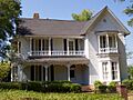
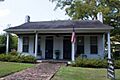
- Col. Chap Anderson House: Located at 402 N. Jackson St. in Kosciusko, this house was listed in 1987.
- George Washington Brett House: Found near West, this home was added to the list in 2010.
- David L. Brown House: This house at 200 E. Washington St. in Kosciusko became historic in 1977.
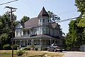
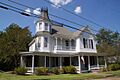
- Col. J.K. Coffey House: East of Sallis, this house was recognized in 1979.
- Jackson-Browne House: At 107 N. Wells St. in Kosciusko, this home was listed in 1987.
- Jackson-Niles House: Just down the street at 121 N. Wells St. in Kosciusko, it joined the list in 1984.
- Johnson-Sullivant House: This Kosciusko home at 709 S. Wells St. was added in 1986.
- John Kimbrough Hall House: About five miles north-northwest of Ethel, this house was listed in 1998.
- John Copeland Lucas House: At 500 N. Huntington St. in Kosciusko, it was recognized in 1993.
- Niles House: This house at 401 N. Huntington St. in Kosciusko was listed in 1998.
- Judge Henry C. Niles House: Another Kosciusko home at 305 N. Huntington St., added in 1993.
- Shrock House: Located on Shrock Rd. near Goodman, this house was listed in 1985.
- Storer House: At 300 N. Huntington St. in Kosciusko, this home was added in 2003.
Important Public Buildings and Sites
Beyond homes, other types of places are also recognized for their historical value. These include buildings that served the community and important historical pathways.
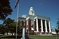
- Attala County Courthouse and Confederate Monument: This important building at 230 W. Washington St. in Kosciusko was listed in 1997. Courthouses are often central to a county's history.
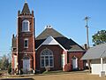
- Old First Presbyterian Church: Located at the junction of Huntington and Washington Sts. in Kosciusko, this church was recognized in 1992. Old churches often show us about early community life and architecture.
- Thompson School: East of Ethel on Ethel-McCool Rd., this school was listed in 1994. Schools are important for understanding the history of education in a community.
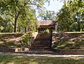
- Old Natchez Trace: A section northeast of Kosciusko was listed in 1976. The Natchez Trace is a very old historic path that was used by Native Americans, explorers, and traders for centuries.
Kosciusko Historic District
The Kosciusko Historic District is a larger area in Kosciusko that includes many historic buildings. It's roughly bounded by streets like Illinois, N. Wells, S. Natchez, and others. This district was added to the National Register in 2009. Listing a whole district helps preserve the overall historic feel and look of a town's older parts.
Images for kids
-
The Col. Chap Anderson House in Kosciusko.
-
The Attala County Courthouse.
-

The Col. J.K. Coffey House.
-
The Jackson-Browne House.
-
The Jackson-Niles House.
-
The Niles House.
-
The Judge Henry C. Niles House.
-
The Old First Presbyterian Church in Kosciusko.
.jpg)


.jpg)
.jpg)
.jpg)
.jpg)
.JPG)
