Attala County, Mississippi facts for kids
Quick facts for kids
Attala County
|
|
|---|---|

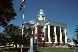
Attala County courthouse in Kosciusko
|
|

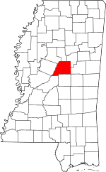
Location within the U.S. state of Mississippi
|
|
 Mississippi's location within the U.S. |
|
| Country | |
| State | |
| Founded | 1833 |
| Seat | Kosciusko |
| Largest city | Kosciusko |
| Area | |
| • Total | 737 sq mi (1,910 km2) |
| • Land | 735 sq mi (1,900 km2) |
| • Water | 1.7 sq mi (4 km2) 0.2% |
| Population
(2020)
|
|
| • Total | 17,889 |
| • Density | 24.273/sq mi (9.372/km2) |
| Time zone | UTC−6 (Central) |
| • Summer (DST) | UTC−5 (CDT) |
| Congressional district | 2nd |
Attala County is a county located in the state of Mississippi. In 2020, about 17,889 people lived here. Its main town, or county seat, is Kosciusko. Attala County got its name from Atala. She is a made-up Native American hero from a book written in the early 1800s by François-René de Chateaubriand.
Contents
Exploring Attala County's Location
Attala County covers about 737 square miles. Most of this area is land, with a small part being water. The Big Black River, which flows into the Mississippi River, forms the western border of the county.
Main Roads in Attala County
These are some of the important roads that go through Attala County:
 Mississippi Highway 12
 Mississippi Highway 14
 Mississippi Highway 19
 Mississippi Highway 35
 Mississippi Highway 43
- Natchez Trace Parkway
Neighboring Counties
Attala County shares its borders with these other counties:
- Montgomery County (to the north)
- Choctaw County (to the northeast)
- Winston County (to the east)
- Leake County (to the south)
- Madison County (to the southwest)
- Holmes County (to the west)
- Carroll County (to the northwest)
Protected Natural Areas
Part of the Natchez Trace Parkway is located within Attala County. This parkway is a special area that protects history and nature.
People of Attala County
In 2020, there were 17,889 people living in Attala County. This number has changed over the years. For example, in 1940, the population was higher. The county is home to a mix of different people and families.
Towns and Communities
Attala County has several towns and smaller communities.
Cities
- Kosciusko (This is the main town, also called the county seat.)
Towns
Unincorporated Communities
These are smaller places that are not officially organized as cities or towns:
- Hesterville
- McAdams
- Possumneck
- Williamsville
- Zama
Old or "Ghost" Towns
Some communities that used to exist are now gone:
Famous People from Attala County
- Myrtis Methvin was born in Attala County in 1895. She became the second woman mayor in Louisiana, serving in Castor from 1933 to 1945.
- John D. Winters, a historian who studied the American Civil War, was born here in 1917.
- Kiliahote, a Chief of the Choctaw Nation, was born in Attala County in 1826.
See Also
 In Spanish: Condado de Attala (Misisipi) para niños
 | Claudette Colvin |
 | Myrlie Evers-Williams |
 | Alberta Odell Jones |

