
National Register of Historic Places listings in Audubon County, Iowa facts for kids

Have you ever wondered about the oldest and most important buildings in your area? In Audubon County, Iowa, there are 14 special places that are listed on the National Register of Historic Places. This is a list kept by the United States government to recognize buildings, sites, and objects that are important to history. These places help us understand the past of Audubon County and the people who lived there.
Many of these historic spots are connected to the Danish immigrants who settled in this part of Iowa. They built homes, churches, and businesses that still stand today. Let's explore some of these amazing places!
Contents
Historic Buildings in Audubon County
Audubon County Courthouses
The Current Courthouse
The Audubon County Court House is a beautiful building in Audubon, Iowa. It was built in 1939 and designed in a style called PWA Moderne. This style was popular during the New Deal era, a time when the government helped create jobs and build new things across the country. This courthouse is special because it's one of ten courthouses in Iowa built with help from the federal Public Works Administration. It's located at 318 Leroy Street.
The First Courthouse
Before the current courthouse, there was an older one in Exira, Iowa. This building, located at Washington and Kilworth Streets, served as the Audubon County Courthouse from 1874 to 1879. It was the very first building made specifically for the county government! Later, in 1887, a group called the Knights of Pythias Lodge used the building. They rented out the bottom floor for traveling music shows, theater groups, and even early silent movies. It was also a popular spot for community plays and dances.
Danish Heritage Buildings
Many of the historic places in Audubon County show the strong influence of Danish immigrants who settled here.
Churches with Danish Roots
- Bethany Danish Evangelical Lutheran Church: This church, built in 1898, is located about 1.5 miles north of Iowa Highway 44 and 1 mile east of Iowa Highway 68 near Kimballton, Iowa. It's important because it shows the history of the Danish Lutheran Church in the area, especially after a big split happened in 1894.
- Immanuel Danish Evangelical Lutheran Church: You can find this church on the eastern side of West 2nd Street in Kimballton, Iowa. Built by Danish immigrants, it features Gothic and Queen Anne styles. This church is significant because of its connection to another part of the Danish Lutheran Church, the Grundtvigian synod, after the 1894 split.
Homes Built by Danish Settlers
- John D. Bush House: This house, located at 219 North Kilworth Street in Exira, Iowa, was built in 1873. It's a type of house called a Gabled-ell house. What makes it special is that it was built by Jens Uriah Hansen, a Danish immigrant carpenter who was the first Dane to settle in Audubon County.
- Andrew P. Hansen Farmstead: This farm, built in 1894, is located between Iowa Highway 44 and County Road P58 on Little Elkhorn Creek, near Brayton, Iowa. It includes a hipped foursquare house, all built by Danish immigrants.
- Hans M. Koch House: Found on the western side of Iowa Highway 173, about half a mile south of Kimballton, Iowa, this 1908 home is a "gabled double-pile" style. It was built as the manager's house for the Crystal Springs brickworks.
- Jens T. Larsen House: At 103 Main Street in Kimballton, Iowa, stands this 1894 gabled ell house. It's a great example of the amazing skills of Danish immigrant craftsmen, Anders and Thorvald Jensen.
Other Important Danish Buildings
- Bennedsen, Boldt, and Hansen Building: This commercial building on Main Street in Kimballton, Iowa, was built in 1913 by Danish immigrant settlers. It shows how they helped build the town's businesses.
- Hans J. Jorgensen Barn: Located at the junction of Iowa Highway 44 and Main Street in Kimballton, Iowa, this barn has a unique square shape with a pyramid-like roof. It was built by Hans J. Jorgensen, a Danish immigrant who was very important in helping Kimballton grow.
Historic Districts
Sometimes, not just one building, but a whole area is considered historic. These are called "historic districts."
- Audubon County Home Historic District: This district is located at 1891 215th Street, near Audubon, Iowa.
- Kimballton Commercial District: This area, around the junction of Alfred and Main Streets in Kimballton, Iowa, includes commercial buildings built between 1889 and 1940. They are important because they show the influence of Danish immigrant and Danish American craftsmanship in the town's businesses.
- Kimballton West 2nd – West 3rd Street Residential District: This neighborhood in Kimballton, Iowa, includes homes from the late 1800s and early 1900s. You can see different architectural styles like Queen Anne, Colonial Revival, Prairie School, and Craftsman homes here. It's roughly along West 2nd Street from Iowa Highway 44 to south of Odense Street, and West 3rd Street from Iowa Highway 44 to Esbeck Street.
- Poplar Rural District: This district is a Danish farming community located roughly from Poplar south and west to Wolf Creek, near Jacksonville, Iowa. It was part of the largest rural Danish immigrant settlement in Iowa and the United States. Even today, the area looks much like it did in the early 1900s.
These historic places help us remember the past and appreciate the hard work and culture of the people who built Audubon County.
Images for kids
-
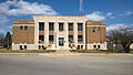
The Audubon County Court House, built in 1939.

