
National Register of Historic Places listings in Bibb County, Georgia facts for kids
Bibb County, Georgia, is home to many amazing places that are part of the National Register of Historic Places (NRHP). This special list includes buildings, areas, and sites that are important to American history, architecture, archaeology, engineering, or culture. When a place is added to the NRHP, it means it's recognized for its historical value and often helps protect it for future generations. In Bibb County, you can find everything from old houses and churches to parks and even entire neighborhoods that tell stories about the past.
Historic Homes and Buildings
Many of Bibb County's historic places are beautiful old homes and important buildings. These structures often show us how people lived and what kind of architecture was popular many years ago.
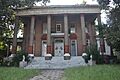
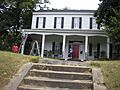
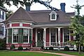
Cannonball House
The Cannonball House at 856 Mulberry Street in Macon is a famous landmark. It got its name because it was hit by a cannonball during the American Civil War. This house helps us remember a challenging time in American history. It was added to the NRHP on May 27, 1971.

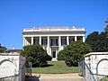
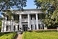
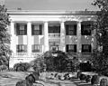
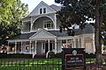
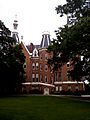
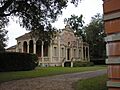
Johnston-Hay House
The Johnston-Hay House, located at 934 Georgia Avenue, is a truly grand mansion. It's so important that it's also a National Historic Landmark, which is an even higher level of historical recognition! This house was listed on the NRHP on May 27, 1971.
.jpg)
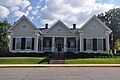
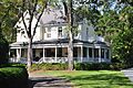
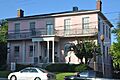
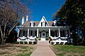
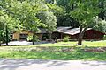
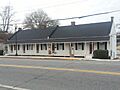
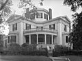
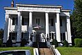
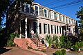
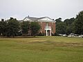
Lassiter House
The Lassiter House at 315 College Street was built in 1855. It's also known as the Bell House and now hosts the Robert McDuffee Center for Strings, a music school. This shows how old buildings can find new life and purpose. It was added to the NRHP on April 11, 1972.
.jpg)
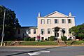
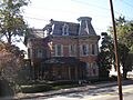
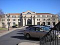
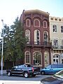
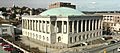
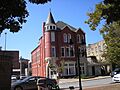
Old U.S. Post Office and Federal Building
The Old U.S. Post Office and Federal Building at 475 Mulberry Street is another significant structure. This building served an important role in the community's communication and government services for many years. It was listed on the NRHP on January 20, 1972.

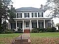
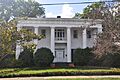
Other Notable Houses
- Capt. R. J. Anderson House (1730 West End Ave., listed 1971)
- Judge Clifford Anderson House (642 Orange St., listed 1971)
- Ambrose Baber House (577-587 Walnut St., listed 1973)
- Thomas C. Burke House (1085 Georgia Ave., listed 1971)
- Cowles House (988 Bond St., listed 1971)
- Jerry Cowles Cottage (4569 Rivoli Dr., listed 1971)
- Dasher-Stevens House (904 Orange Ter., listed 1972)
- Davis-Guttenberger-Rankin House (134 Buford Pl., listed 1973)
- Domingos House (1261 Jefferson Ter., listed 1971)
- Green-Poe House (841-845 Poplar St., listed 1971)
- Hatcher-Groover-Schwartz House (1144-1146 Georgia Ave., listed 1971)
- Walter R. Holt House (3776 Vineville Ave., listed 2005)
- Holt–Peeler–Snow House (1129 Georgia Ave., listed 1971)
- Ellamae Ellis League House (1790 Waverland Dr., listed 2005)
- Joseph and Mary Jane League House (1849 Waverland Dr., listed 2009)
- W. G. Lee Alumni House (1270 Ash (Coleman) St., listed 1971)
- William and Jane Levitt House (3720 Overlook Dr., listed 2016)
- DeWitt McCrary House (320 Hydrolia St., listed 1974)
- Munroe-Dunlap-Snow House (920 High St., listed 1971)
- Munroe-Goolsby House (159 Rogers Ave., listed 1972)
- Raines-Carmichael House (1183 Georgia Ave., listed 1971)
- Randolph-Whittle House (1231 Jefferson Ter., listed 1972)
- Rock Rogers House (331 College St., listed 1972)
- Slate House (931-945 Walnut St., listed 1974)
- Small House (156 Rogers Ave., listed 1971)
- Solomon-Smith-Martin House (2619 Vineville Ave., listed 1971)
- Villa Albicini (150 Tucker Rd., listed 1974)
- Willingham-Hill-O'Neal Cottage (535 College St., listed 1971)
Important Public Places
Bibb County also has many public spaces and buildings that are historically significant.
Ocmulgee National Monument
The Ocmulgee National Monument is a very important archaeological site east of Macon. It protects ancient Native American mounds and tells the story of people who lived in this area thousands of years ago. It's so special that it's a National Monument and was listed on the NRHP on October 15, 1966. It is managed by the National Park Service.

Grand Opera House
The Grand Opera House at 651 Mulberry Street is a beautiful historic theater in Macon. It has hosted countless performances and events over the years, bringing entertainment and culture to the community. It was listed on the NRHP on June 22, 1970.

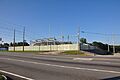
Luther Williams Field
Luther Williams Field is a historic baseball stadium located at 225 Willie Smokey Glover Blvd. in Central City Park. It's one of the oldest baseball parks in the United States and has seen many games and players over the decades. It was added to the NRHP on June 24, 2004.

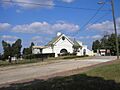
Other Public and Commercial Buildings
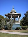
- Central City Park Bandstand (Central City Park, listed 1972)
- Emerson-Holmes Building (566 Mulberry St., listed 1971)
- First Presbyterian Church (690 Mulberry St., listed 1972)
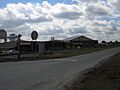
- Fort Hawkins Archeological Site (Address Restricted, listed 1977)
- Macon Railway and Light Company Substation (1015 Riverside Dr., listed 2006)
- Mechanics Engine House No. 4 (950 Third St., listed 1990)
- Mercer University Administration Building (Coleman Ave., listed 1971)
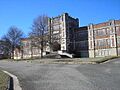
- A.L. Miller High School and A.L. Miller Junior High School (2241 Montpelier Ave., listed 2014)
- Militia Headquarters Building (552-564 Mulberry St., listed 1972)
- Monroe Street Apartments (641-661 Monroe St., listed 1972)
- Municipal Auditorium (415-435 1st St., listed 1971)
- Old Macon Library (652-662 Mulberry St., listed 1973)
- Railroad Overpass at Ocmulgee (Off GA 49, listed 1979)
- Riverside Cemetery (1301 Riverside Dr., listed 1983)
- Rose Hill Cemetery (Riverside Dr., listed 1973)
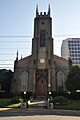
- St. Joseph's Catholic Church (812 Poplar St., listed 1971)
- Wesleyan College Historic District (4760 Forsyth Rd., listed 2004)
Historic Districts
A historic district is a group of buildings, structures, or sites that are historically or architecturally important together. These districts help preserve the unique character and history of entire neighborhoods.
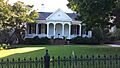
Macon Historic District
The Macon Historic District is a large area roughly bounded by Riverside Drive, Broadway, Elm, and I-75. This district includes many of the individual historic buildings already mentioned and helps protect the overall historic feel of downtown Macon. It was listed on the NRHP on December 31, 1974.
.jpg)
Ingleside Historic District
The Ingleside Historic District is a neighborhood roughly bounded by Vineville Avenue, Candler Drive, Bonita Place, High Point Road, and Forest Hill Road. This area is known for its beautiful homes and historic streetscapes. It was added to the NRHP on May 10, 2016.

Shirley Hills Historic District
The Shirley Hills Historic District is another significant neighborhood, roughly bounded by Senate Place, Parkview Drive, Curry Drive, Briarcliff Road, Nottingham Drive, and the Ocmulgee River. This district also had a boundary increase in 2014, showing its growing importance. It was listed on the NRHP on August 17, 1989.

Other Historic Districts
- Cherokee Brick and Tile Company (3250 Waterville Rd., listed 2002)
- Cherokee Heights District (Pio Nono, Napier, Inverness, and Suwanee Aves., listed 1982)
- East Macon Historic District (Roughly bounded by Emery Hwy., Coliseum Dr., and Clinton, Fletcher and Fairview Sts., listed 1993)
- Fort Hill Historic District (Roughly bounded by Emery Hwy., Second St. Ext., Mitchell and Morrow Sts. and Schaeffer Pl., listed 1993)
- Macon Railroad Industrial District (Roughly bounded by Fifth, Sixth, and Seventh Sts., Central of Georgia, Southern, and Seaboard RR tracks, listed 1987)
- North Highlands Historic District (Roughly bounded by Nottingham Dr., Boulevard and Clinton Rd., listed 1993)
- Pleasant Hill Historic District (Roughly bounded by Sheridan Ave. and Schofield St., Madison, Jefferson and Ferguson, and Galliard Sts., listed 1986)
- Tindall Heights Historic District (Roughly bounded by Broadway, Eisenhower Pkwy., Felton and Nussbaum Aves., Central of Georgia RR tracks and Oglethorpe St, listed 1993)
- Vineville Historic District (GA 247 and U.S. 41, listed 1980)
Images for kids
-
Capt. R. J. Anderson House
-
Judge Clifford Anderson House
-
Ambrose Baber House
-
Thomas C. Burke House
-
Central City Park Bandstand
-
Cherokee Brick and Tile Company
-
Christ Episcopal Church
-
Collins-Odom-Strickland House
-
Cowles House
-
Jerry Cowles Cottage
-
Dasher-Stevens House
-
Davis-Guttenberger-Rankin House
-
Domingos House
-
Emerson-Holmes Building
-
First Presbyterian Church
-
Fort Hawkins Archeological Site
-
Green-Poe House
-
Hatcher-Groover-Schwartz House
-
Walter R. Holt House
-
Holt–Peeler–Snow House
-
Sidney Lanier Cottage
-
Ellamae Ellis League House
-
Joseph and Mary Jane League House
-
W. G. Lee Alumni House
-
William and Jane Levitt House
-
Macon Railroad Industrial District
-
Macon Railway and Light Company Substation
-
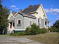
DeWitt McCrary House
-
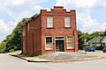
Mechanics Engine House No. 4
-
Mercer University Administration Building
-
A.L. Miller High School and A.L. Miller Junior High School
-
Militia Headquarters Building
-
Monroe Street Apartments
-
Municipal Auditorium
-
Munroe-Dunlap-Snow House
-
Munroe-Goolsby House
-
Old Macon Library
-
Pleasant Hill Historic District
-
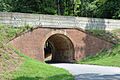
Railroad Overpass at Ocmulgee
-
Raines-Carmichael House
-
Randolph-Whittle House
-
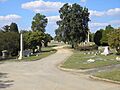
Riverside Cemetery
-
Rock Rogers House
-
Rose Hill Cemetery
-
Slate House
-
Small House
-
Solomon-Smith-Martin House
-

St. Joseph's Catholic Church
-
Villa Albicini
-
Wesleyan College Historic District
-
Willingham-Hill-O'Neal Cottage


.JPG)


.jpg)


.JPG)


.jpg)


